


HELENA — Montana’s Districting and Apportionment Commission was expected to bring out a single draft map for the state’s two new congressional districts Thursday. However, enough disagreements remained that they instead moved forward two proposals for the public to weigh in on.
At the beginning of Thursday’s work session, commission chair Maylinn Smith urged the commission’s two Democratic members and two Republican members to move toward consensus.
“Our goal here is to do what’s best for Montana,” she said.
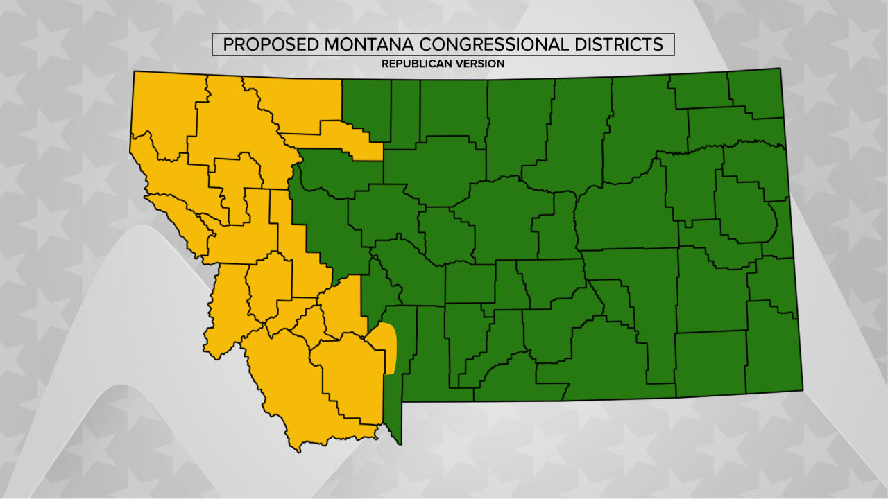
Both sides did offer updated maps intended to address some of the concerns about their initial proposals. Both maps break the state into western and eastern districts, and each one splits only a single county.
Republicans’ proposal would break up Gallatin County, with the city of Bozeman, Belgrade, Manhattan and Three Forks in the west and other parts of the county in the east. Lewis and Clark County, including Helena, would be in the eastern district, while Glacier and Pondera Counties, including the Blackfeet Nation, would be in the western district.
Democrats’ proposed map would keep all of Gallatin County in the western district, along with Park County and Lewis and Clark County. It would instead split Flathead County, with the Whitefish and Olney areas in the west and the rest of the county – including Kalispell, Columbia Falls and Bigfork – in the east.
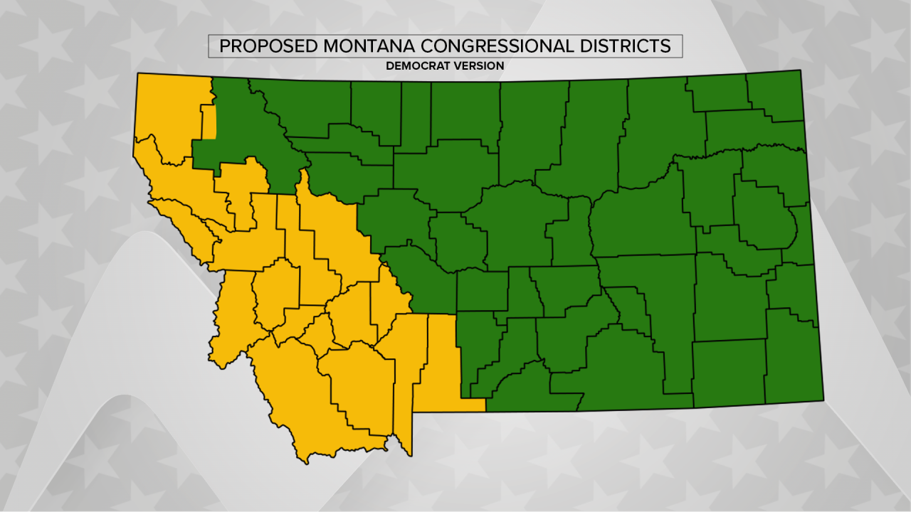
Smith had said during the meeting that she wanted the final map to split as few counties as possible, maintain communities of interest together and not “unduly” favor one party or the other. She suggested it might make sense to split either Flathead or Gallatin County, as they are the fastest growing large counties in the state.
For weeks, the biggest point of disagreement has been over what criteria should be most important in drawing the districts. Republicans have favored districts that they say are compact and geographically logical, while Democrats have called for making one of the districts competitive – meaning both Republican and Democratic candidates would have a chance to win. Throughout Thursday’s session, the commissioners debated the best way to determine competitiveness from previous election data.
These two maps were far more similar than the original group of nine proposals the commissioners had suggested, but each side remained sharply critical of the other’s latest plan.
Democrats were unhappy with the idea of putting Lewis and Clark County in the eastern district, saying it had links to other southwestern Montana cities. They said Republicans had still delivered a map that would heavily favor their candidates in both districts.
“Your options are invariably, well, you have to go into an area that is very competitive over there and do what is called ‘cracking,’ which is dilute it and throw it into the east,” said Commissioner Joe Lamson. “That’s what this map does. It doesn’t even approach competitiveness.”
Republicans argued that breaking up Flathead County and combining Kalispell with a district mostly east of the Continental Divide didn’t make sense either. They said it would be possible to have competitive elections in their western district, and they claimed the Democratic map itself was disadvantaging one party.
“It was just mentioned earlier that somehow Republicans were packing and cracking,” said Commissioner Dan Stusek. “This is packing and cracking Republicans.”
Smith acknowledged the challenges lying ahead.
“Every line you draw has political implications, and to think otherwise is just being either naïve or unrealistic,” she said.
She said she wants to hear public comment on each of these proposals. While she still expressed hope for consensus, she said she may select one of these two maps as the final draft plan.
The commission will take public comment during a hearing Oct. 30, a Saturday. Smith said the time for comment will be limited, and she encouraged people to send in written responses before the hearing.
You can find interactive maps of the new proposals, dubbed “CP 10” and “CP 11,” at the Districting and Apportionment Commission website. You can also find information there on how to submit public comment.
Commissioners will hold a work session in the afternoon of Oct. 30, where they are expected to choose a single map. They will hold another public hearing on that map proposal the following week, before the potential final adoption.
