


A WINTER WEATHER ADVISORY is in effect for portions of southwestern Montana until 5am Wednesday. 1 to 3 inches of snow accumulation is possible in the lower elevations and 4 to 10 inches of snow accumulation is possible in the mountains. Winds are also going to be gusting as high as 40 mph.

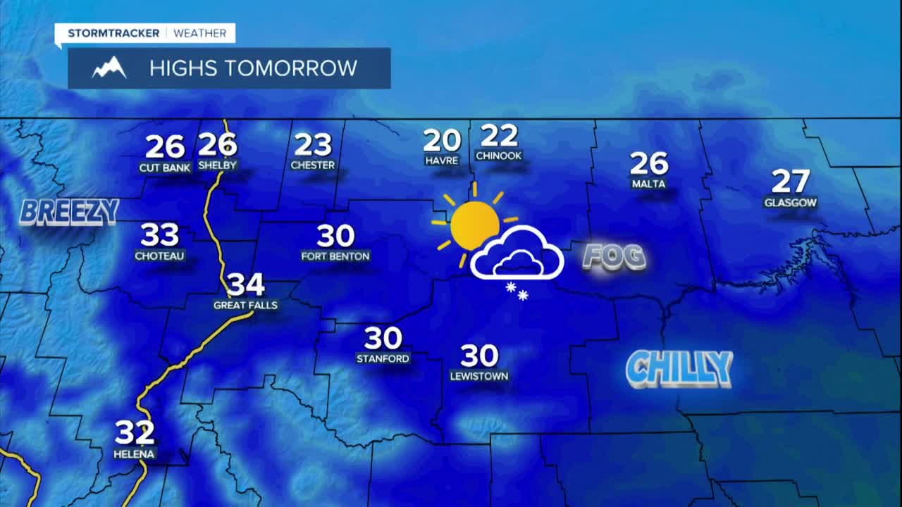
There are going to be a few widely scattered snow showers around this evening and tonight, generally in the mountains as well as in locations east of I-15. There are then going to be a few scattered snow showers around tomorrow in central Montana, generally in the mountains, and there are going to be a few isolated snow showers around tomorrow in north-central Montana. Through tomorrow night, up to 3 inches of snow accumulation is possible in the mountains, while less than an inch of snow accumulation is expected in the lower elevations, with most lower elevation locations receiving little to no snow accumulation. We are also going to have partly cloudy skies tonight and tomorrow with patchy areas of fog around later on tonight and tomorrow morning.
It is also going to be cold tonight, although it is not going to be as cold as it was last night, as lows are going to be in the -0s, 0s, and 10s in most locations. It is then going to be warmer tomorrow than it was today as highs are going to be in the 20s and low to mid 30s in most locations. There is also going to be a breeze around tonight and tomorrow along the Rocky Mountain Front as sustained wind speeds are going to be between 10 and 25 mph. Elsewhere, there is just going to be a little breeze around tonight and tomorrow as sustained wind speeds are generally going to be between 5 and 15 mph.
On Wednesday, we are going to have partly cloudy to mostly sunny skies with a couple isolated snow showers around during the morning along the eastern half of the Hi-Line. It is also going to be chilly and a little breezy on Wednesday as highs are going to be in the 20s and low to mid 30s, and sustained wind speeds are going to be between 5 and 20 mph, with stronger wind along the Rocky Mountain Front.
Lots of sunshine and dry conditions are then expected on Thursday and Friday, and partly cloudy skies and dry conditions are expected on Saturday as high pressure is going to be in control of our weather. The temperatures are also going to warm up a lot over these three days as highs are going to be in the upper 20s, 30s, and low 40s on Thursday; the mid to upper 30s and low to mid 40s on Friday; and the mid to upper 40s and low to mid 50s on Saturday. The wind is also going to pick up over these three days as it is going to be a little breezy on Thursday (sustained wind speeds between 5 and 20 mph); it is going to be breezy in some areas on Friday (sustained wind speeds between 10 and 20 mph); and widespread breezy conditions are expected on Saturday (sustained wind speeds between 10 and 25 mph).
Partly cloudy skies and mostly dry conditions are then expected on Sunday and Monday as this area of high pressure begins to move away from our area allowing a few disturbances to begin to work their way into western Montana. It is also going to be mild on these two days as highs are going to be in the mid to upper 40s and low to mid 50s. Breezy conditions are also expected on these two days as sustained wind speeds are going to be between 10 and 25 mph.


