

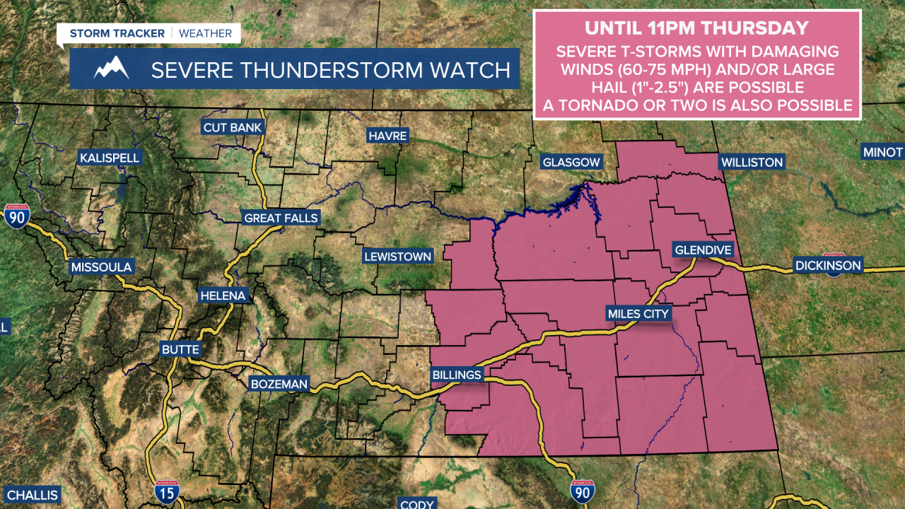
Scattered showers and thunderstorms are expected this evening and tonight as an upper-level trough is impacting our area. The threat for severe weather this evening and tonight will primarily be in eastern Montana where a SEVERE THUNDERSTORM WATCH is in effect until 11pm tonight, but a couple strong to severe thunderstorms are possible in north-central Montana. Severe or not, gusty winds, small to medium-sized hail, frequent lightning, and brief heavy rainfall will be possible with the thunderstorms that we do see, so please be weather aware if you are going to be outdoors at all.
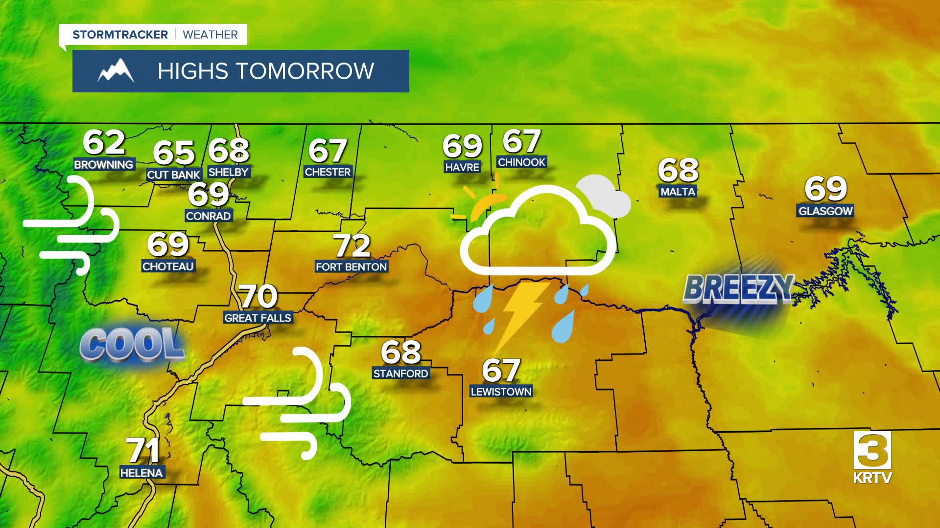
More scattered showers and thunderstorms are expected tomorrow in north-central Montana. During the morning, most of the shower and thunderstorm activity will be east of I-15, but during the afternoon and evening, the scattered showers and thunderstorms will be all throughout north-central Montana. Around Helena, there are going to be a few scattered showers and thunderstorms around tomorrow, especially in the mountains. We are also going to have partly to mostly cloudy skies tomorrow, with more sunshine in central Montana and more cloud cover in north-central Montana.
It is going to be cool tonight and tomorrow as lows tonight are going to be in the mid to upper 40s and low to mid 50s and highs tomorrow are going to be in the 60s and low 70s. It is also going to be breezy tonight along the Rocky Mountain Front as sustained wind speeds are going to be between 10 and 25 mph, and it is going to be a bit breezy tonight across the plains as sustained wind speeds are going to be between 5 and 20 mph. A gusty westerly breeze is then expected tomorrow as sustained wind speeds are going to be between 10 and 25 mph, and wind gusts up to 40 mph are possible.
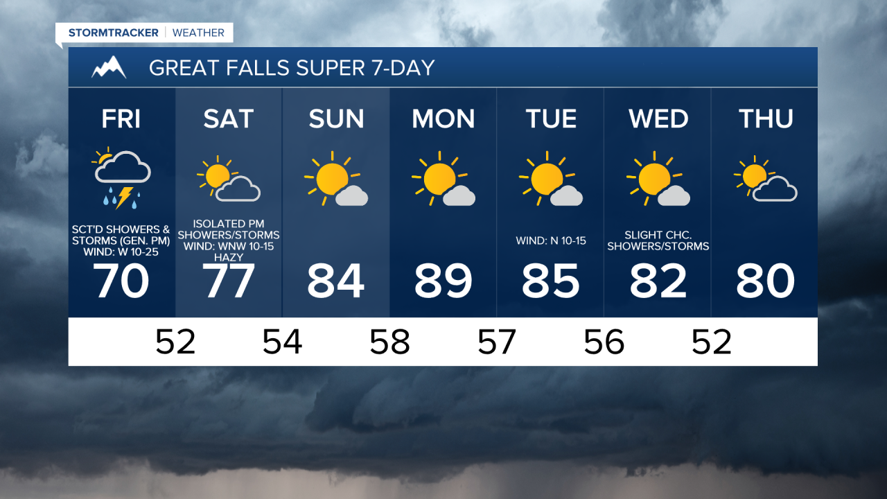
On Saturday, we are going to have a mixture of sun and clouds with some scattered showers and thunderstorms around, generally in locations east of I-15 in north-central Montana, as the upper-level trough begins to pull away from our area. Around and west of I-15, it will be a bit breezy on Saturday as sustained wind speeds are going to be between 10 and 20 mph. East of I-15, it will be gusty/windy, with the wind getting stronger the further east you go, as sustained wind speeds are going to be between 10 and 30 mph, and wind gusts up to 50 mph are possible. Warmer temperatures are also expected on Saturday as highs are going to be in the 70s.
Canadian wildfire smoke will also return to central and eastern Montana on Saturday, and this smoke may cause the air quality to be unhealthy for sensitive groups or unhealthy for everyone at times.

For Sunday and Monday, we are going to have mostly sunny skies and dry conditions as an upper-level ridge is going to be in control of our weather. The temperatures are also going to warm up some over these two days as highs are going to be in the upper 70s and low to mid 80s on Sunday and the 80s and low 90s on Monday. It is also going to be a little breezy on Sunday as sustained wind speeds are going to be between 5 and 20 mph.
A few disturbances will attempt to impact Montana during the middle of next week, so a few isolated showers and thunderstorms are possible Tuesday, Wednesday, and Thursday. Many locations will remain dry though with mostly sunny skies. The temperatures are also going to cool down a little bit over these three days as highs are going to be in the upper 70s and low to mid 80s on Tuesday; the mid to upper 70s and low to mid 80s on Wednesday; and the 70s and low 80s on Thursday. It is also going to be a little breezy on these three days as sustained wind speeds are going to be between 5 and 20 mph.