


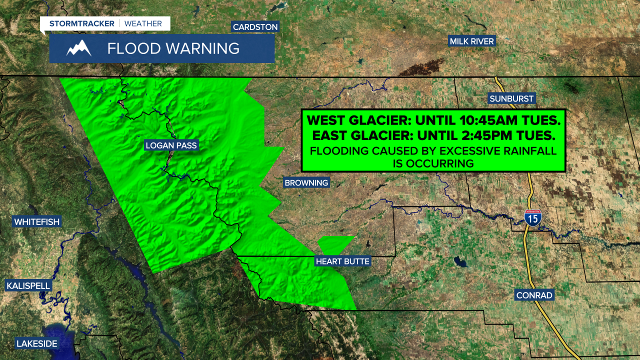
Good Morning and Happy Tuesday! It has been wet and cool in Montana for the past few days as a storm system has been impacting the state. Since Friday morning, most of central and north-central Montana has received .75” to 3” of rain. In Glacier National Park, excessive rainfall has fallen over the past couple of days, with a lot of the park receiving 2-6+” of precipitation. This excessive rainfall led to flooding in parts of the park, especially the Many Glacier part of the park, which was evacuated on Monday and is currently closed due to flooding.


A FLOOD WARNING remains in effect for Glacier National Park through later this morning/early this afternoon. The heaviest rainfall is now done with, but it will take some time for the flood waters to recede and for the water levels to lower. If you will be recreating in Glacier National Park this week, be aware of all of the trail closures and be careful around all waterways as they will be running fast.
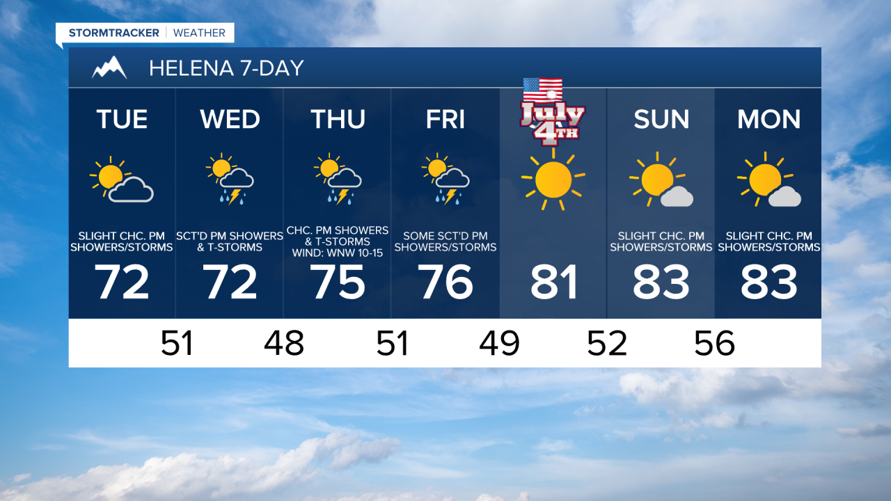
Sunnier, warmer, and drier weather is in the forecast for today as the storm system begins to pull away from our area. Today, it is going to be partly cloudy and there are going to be some scattered showers and thunderstorms around, especially during the afternoon and evening. Highs today are going to be in the upper 60s and low to mid 70s, so it is going to feel really nice outside. In eastern portions of north-central Montana, it is going to be breezy today as sustained wind speeds are going to be between 10 and 25 mph, and gusts up to 40 mph are possible. Elsewhere, there is going to be a bit of a breeze around today as sustained wind speeds are going to be between 10 and 20 mph.
There will also be some haze around today east of the Divide as northwesterly flow aloft brings Canadian wildfire smoke into our area. At times today, the air quality may become unhealthy for sensitive groups. The haze will diminish tonight.
Tomorrow, it is going to be partly cloudy, with the cloud cover increasing as the day goes on. Around the Helena area, there are going to be scattered showers and thunderstorms around tomorrow afternoon/evening. In north-central Montana, there are going to be a few showers and thunderstorms around tomorrow afternoon/evening, generally in locations east of I-15 and in the mountains. It is also going to be mild again tomorrow as highs are going to be in the upper 60s and low to mid 70s and there is just going to be a little breeze (5-20 mph) around.
On Thursday and Friday, it is going to be partly to mostly sunny and there will be some scattered showers and thunderstorms around, generally during the PM hours and generally in central Montana and in locations east of I-15 in north-central Montana, as we remain in an unsettled weather pattern. It is also going to feel nice outside on these two days as highs are going to be in the 70s in most locations. There is also only going to be a little breeze around as sustained wind speeds are going to be between 5 and 20 mph.
Beautiful weather is in the forecast for the upcoming holiday weekend as an upper-level ridge is going to be in control of our weather. Independence Day will have almost perfect weather with lots of sunshine, dry conditions, and warm temperatures as highs are going to be in the upper 70s and low to mid 80s. There is also going to be a little breeze around on Saturday as sustained wind speeds are going to be between 5 and 20 mph.
Sunday will feature very nice weather as well as it is going to be mostly sunny and mostly dry, just a few isolated showers and thunderstorms around later in the day. It is also going to be warm again on Sunday as highs are going to be in the upper 70s and low to mid 80s.


Have a tremendous Tuesday!
Chief Meteorologist Ryan Dennis
