


It was a beautiful start to the work week with partly to mostly sunny skies, mild temperatures, and little to no wind! The cloud cover will increase as we go through this evening, with mostly cloudy skies expected overnight. It is also going to be cool tonight as lows are going to be in the 30s and low 40s. The wind will increase later tonight along the Rocky Mountain Front. Elsewhere, there will be little to no wind tonight.
Here is the detailed forecast:
Tomorrow will be mostly cloudy with rain/snow along the Divide/Rocky Mountain Front, especially during the afternoon and evening, and some scattered rain showers east of I-15, generally during the late afternoon and evening. There will then be some more scattered rain and mountain snow showers around tomorrow night, generally before midnight and mainly in the higher terrain and in locations east of I-15, as a disturbance continues to impact our area.
It will be gusty tomorrow along the Rocky Mountain Front as gusts up to 50 mph are possible. East of the Rocky Mountain Front, it will be breezy in some areas tomorrow as sustained wind speeds are going to be between 10 and 20 mph, and wind gusts up to 35 mph are possible. It is also going to be warmer tomorrow than it was today as highs are going to be in the 50s and low to mid 60s, with the coolest temperatures along the Hi-Line.
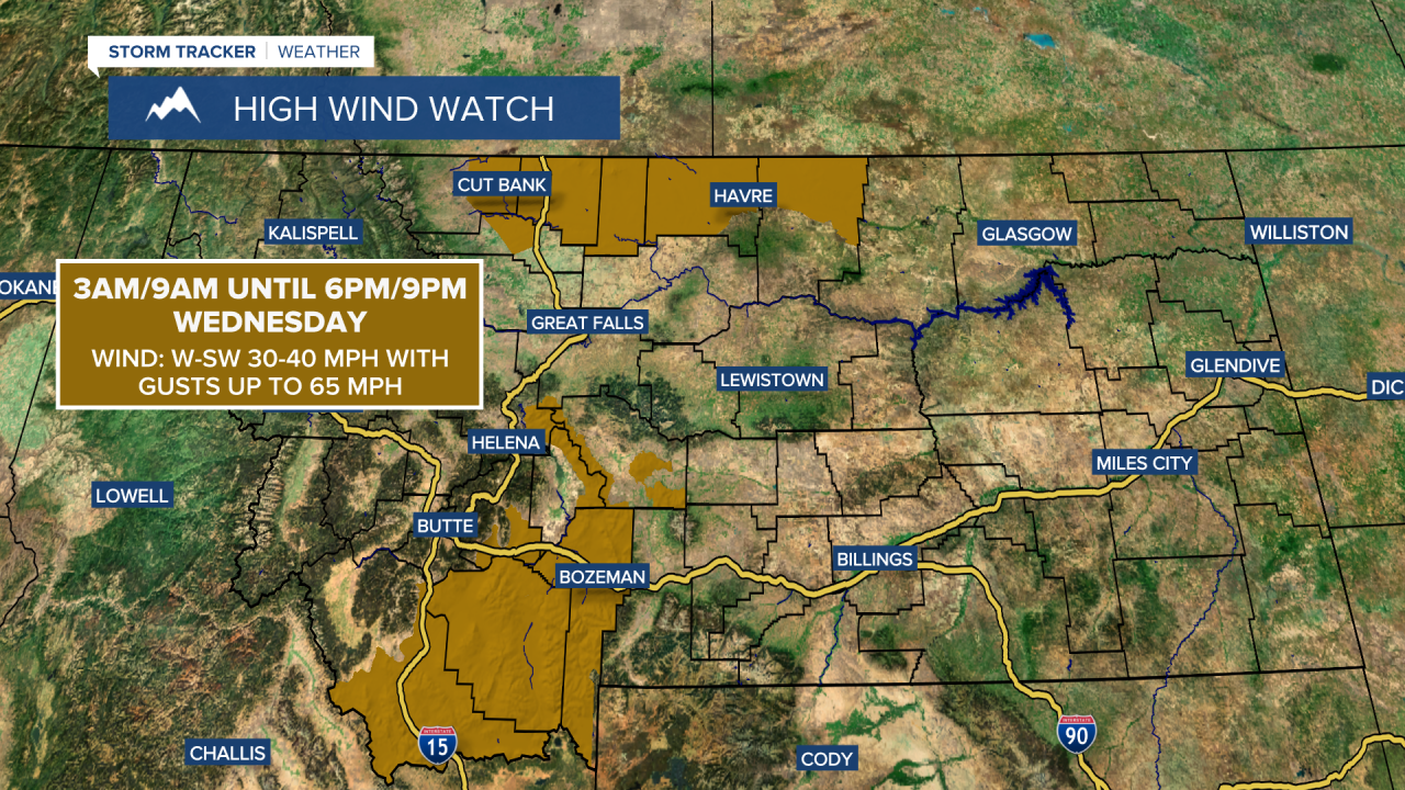
Widespread gusty to strong winds will return to our area on Wednesday. Sustained wind speeds are going to be between 15 and 35 mph, and wind gusts will be between 40 and 65 mph. A HIGH WIND WATCH is in effect for portions of the Hi-Line from Cut Bank to the Blaine/Phillips County line and for portions of southwestern Montana for most of the day as gusts up to 65 mph are possible in these locations.
This wind will also elevate the fire danger, so please do your part to not start any new fires. A FIRE WEATHER WATCH is in effect for most of southwestern and south-central Montana, including the Helena area, from 12pm-9pm on Wednesday.

It is also going to be partly to mostly cloudy on Wednesday and there will be a few scattered rain and mountain snow showers around, mainly in the higher terrain and in locations east of I-15. Highs on Wednesday will be in the mid to upper 50s and low to mid 60s in most spots.
Colder temperatures briefly return on Thursday as highs are going to be in the mid to upper 30s and low to mid 40s, with the coldest temperatures along the Hi-Line. There are also going to be a few scattered snow and rain showers around on Thursday, generally in the mountains and along the Hi-Line east of I-15 and especially during the morning. It is also going to be partly to mostly sunny and breezy on Thursday as sustained wind speeds are going to be between 10 and 25 mph, and wind gusts up to 40 mph are possible.
Pleasant weather is expected Friday through Sunday as an upper-level ridge is going to be in control of our weather. On these three days, it is going to be dry and there is only going to be a little breeze around as sustained wind speeds are going to be between 5 and 20 mph. Friday will be mainly sunny, while Saturday and Sunday will be partly to mostly cloudy. The temperatures are also going to warm back up over these three days as highs on Friday are going to be in the 50s; highs on Saturday are going to be in the mid to upper 50s and low to mid 60s; and highs on Sunday are going to be in the 60s and low 70s.


