


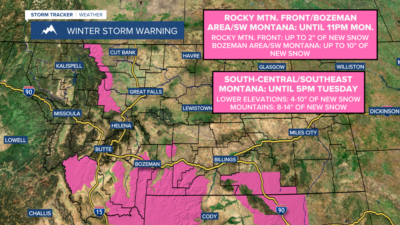
A WINTER STORM WARNING is in effect for the Rocky Mountain Front, portions of southwestern Montana, and the Bozeman area until 11pm Monday.
A WINTER STORM WARNING is also in effect for portions of south-central and southeastern Montana until 5pm Tuesday.
A WINTER WEATHER ADVISORY is in effect for the Great Falls and Helena areas until 7pm/11pm Monday, and for portions of western, south-central, and southeastern Montana until 8am/11am/12pm Tuesday.

A WIND CHILL ADVISORY is in effect for the Hi-Line east of the Divide until 10am/11am Tuesday.

There are going to be some scattered snow showers around tonight, especially before midnight and generally along the Rocky Mountain Front and in central Montana, including around Great Falls and Helena, as a storm system slowly works its way out of our area. In the lower elevations, up to an inch of new snow accumulation is possible tonight, and in the mountains, up to 5 inches of new snow accumulation is possible tonight. We are also going to have partly to mostly cloudy skies tonight with diminishing wind from west to east. It is also going to be frigid tonight as lows are going to be in the -0s and 0s, and wind chills as low as -20° to -35° are possible, especially along the Hi-Line.
For tomorrow, we are going to have partly to mostly cloudy skies with scattered snow showers around, generally in central Montana and along the Rocky Mountain Front, and light snow accumulations of up to an inch or two are possible in locations that see some of this snow. It is also going to be cold tomorrow as highs are going to be in the mid to upper teens and low to mid 20s in most locations. Gusty winds are also expected tomorrow along the Continental Divide and around the Helena area as sustained wind speeds are going to be between 10 and 25 mph.
We are then going to have increasing wind Tuesday night, with widespread gusty to strong winds around on Wednesday and Thursday. Along the Rocky Mountain Front, sustained wind speeds are going to be between 30 and 50 mph, and wind gusts over 70 mph are possible. East of the Rocky Mountain Front, sustained wind speeds are going to be between 15 and 35 mph, and wind gusts over 50 mph are possible. The temperatures are also going to warm up a lot over these two days as highs are going to be in the 40s in most locations on Wednesday and the 50s in most locations on Thursday.
We are also going to have partly to mostly cloudy skies on Wednesday with some isolated snow and rain showers around. On Thursday, we are going to have increasing clouds with developing precipitation during the afternoon and evening for locations around and west of I-15. Widespread precipitation is then expected Thursday night as a storm system passes through our area. This precipitation will start out as rain in the lower elevations, but will switch-over to snow from west to east.
Snow is then likely on Friday around Helena (especially during the morning), and there is going to be some scattered snow/rain around in north-central Montana on Friday as one disturbance leaves our area and as another disturbance begins to approach our area. We are also going to have mostly cloudy skies and colder temperatures on Friday as highs are going to be in the 30s and low 40s. It is also going to be breezy in some areas on Friday as sustained wind speeds are going to be between 10 and 20 mph.
Widespread snow is then likely on Saturday as a storm system passes through our area. There are then going to be scattered areas of snow around on Sunday, especially in the mountains and around the Helena area. We are also going to have mostly cloudy skies this weekend. The temperatures are also going to continue to cool down this weekend as highs are going to be in the 20s and low 30s on Saturday and the mid to upper teens and low to mid 20s on Sunday. There is also going to be a bit of a breeze around in some areas this weekend as sustained wind speeds are going to be between 10 and 20 mph.
There are then going to be some scattered snow showers around on Monday, especially during the morning. It is also going to be chilly on Monday as highs are going to be in the mid to upper 20s and low 30s in most locations. There is also going to be a bit of a breeze around on Monday as sustained wind speeds are going to be between 10 and 20 mph.


