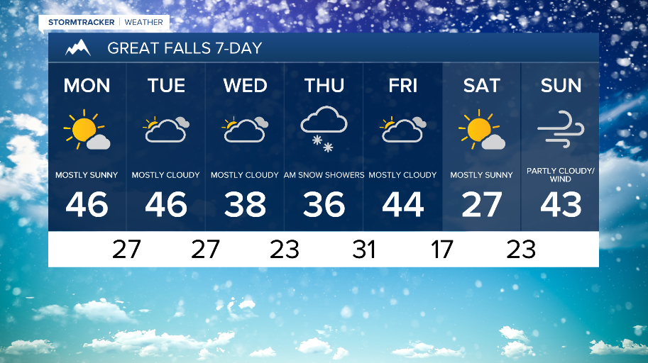
WEATHER DISCUSSION: Cloud cover increased Saturday night to make way for some cloudy/mostly cloudy skies today. Expect chances of lower elevation rain/upper-elevation snow tonight with cloudy/mostly cloudy skies, low temperatures in the teens, 20s, and 30s, and 5 to 10 mph winds with gusts up to 20 mph.
An upper-level shortwave and cold front moving through the region will continue to bring mountain snow and lower elevation rain/snow today and Monday. Snow levels continue to increase as an arctic air mass intruding into the Hi- line tonight will keep colder air at the surface. This combined with warm air will pose a threat for light freezing rain tonight, mainly along the Hi-line along with chances for light freezing/freezing drizzle in Southwest MT tonight.
This is prompting Winter Weather Advisories (purple) for portions along the Hi-line, Central Montana, and the Rocky Mountain front.

Monday, expect sunnier skies in northern portions with partly cloudy/mostly cloudy skies for central and southern locations. The precipitation tapers off through Monday afternoon, making way for some drier conditions. High temperatures are expected in the 30s and 40s. Breezy and gusty winds will be around before decreasing Monday evening, with gusts topping out around 40/50 mph.

A broader trough building along the Pacific Coast this week will keep periods of mountain snow and lower elevation rain/snow. Another chance for freezing rain along the Hi-line is likely on Tuesday through Wednesday morning, as another warm front lifts north and collides with the arctic airmass intruding into the Hi-line.