


Good Morning! Today is Friday, October 9, 2026.
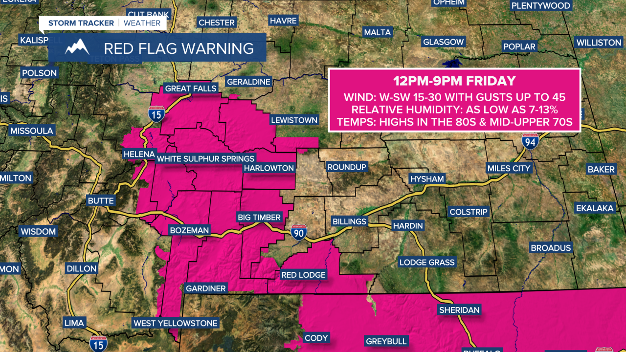
Widespread gusty to strong winds are expected today ahead of an approaching trough. Along the Rocky Mountain Front, sustained winds of 15 to 35 mph are expected, with gusts up to 60 mph possible. Elsewhere, breezy to gusty conditions are likely, with sustained winds of 10 to 30 mph and gusts exceeding 40 mph in some locations. This wind combined with low relative humidity and warm temperatures will elevate the fire danger and a RED FLAG WARNING is in effect for portions of central and south-central Montana, including Great Falls, Helena, and Bozeman, from 12pm until 9pm.
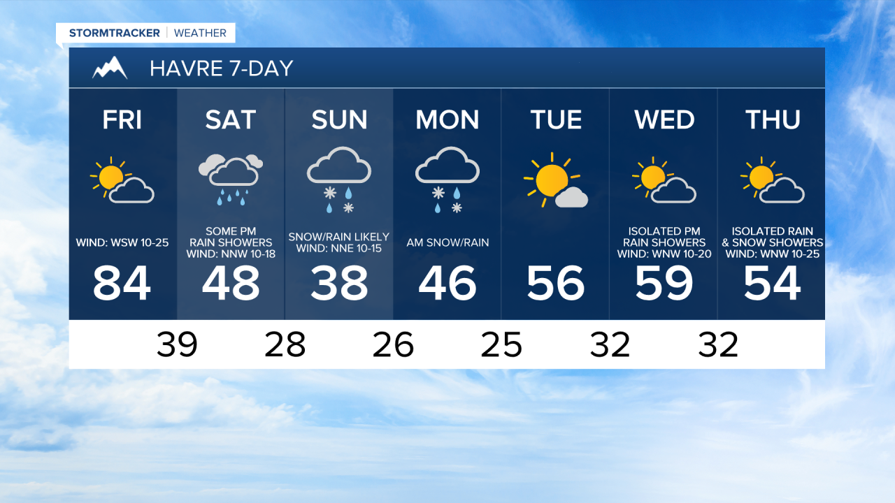
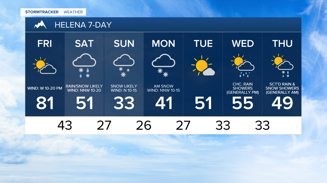
It is also going to be warm today, with highs in the mid to upper 70s and low to mid 80s, and today will likely be the warmest day until next spring. Skies will be partly cloudy tomorrow, and conditions will remain dry, although a few showers are possible along the Rocky Mountain Front during the evening.
A significant cooldown is expected this weekend, with Sunday being the coldest day since last spring. Highs on Saturday will be in the 40s and low to mid 50s, but those highs will occur during the morning, with falling temperatures throughout the day. Sunday will then be a cold day as highs will only be in the 30s and low 40s. There will also be a breeze around this weekend, with sustained winds of 10 to 20 mph, which will make it feel even colder.
Precipitation will develop and become more widespread tomorrow, especially during the afternoon and evening. Widespread precipitation is then expected Saturday night through Monday morning, with precipitation tapering off as Monday progresses as the storm system departs the state.
In the lower elevations, precipitation will initially fall as rain. However, snow levels will fall behind a cold front, allowing rain to mix with and change over to snow tomorrow afternoon through tomorrow night in a lot of locations. A lot of the precipitation that falls Sunday through Monday morning will be in the form of snow, but there will be some embedded areas of rain, especially east of I-15. In northeastern Montana, a chilly rain is expected, but snow may mix in with the rain at times.
In the mountains, 6-12+” of snow is expected through Monday evening. Travel will be difficult at times this weekend and on Monday at and above mountain pass level. In the lower elevations, snow amounts will range from nothing at all to as much as 8”. Right now, the highest snow amounts in the lower elevations look to be around Helena and across southern portions of north-central Montana (Cascade, Fergus, and Judith Basin Counties) as well as along the Rocky Mountain Front. This is where 3-8” of snow is expected. Elsewhere in the lower elevations, generally less than 3” of snow is expected.

Roads may be slick or slushy at times in the lower elevations, especially during the nighttime and morning hours, so please use caution when driving.
Due to the impending snow, a WINTER STORM WATCH is in effect for portions of central and southern Montana, including Great Falls, Helena, and Stanford, from Saturday afternoon/evening through Sunday evening/Monday morning.

There is still a high amount of uncertainty in regards to snow amounts due to multiple factors, including how long it takes the snow to begin accumulating due to the warm ground, how low the snow levels get, when the transition from rain to snow occurs, and where the heaviest precipitation falls.
Tuesday will be a nice day with mostly sunny skies, dry conditions, little to no wind, and warmer temperatures as highs will be back in the mid to upper 40s and low to mid 50s.
The next storm system will impact the state later Wednesday into Thursday. On Wednesday, it will be partly cloudy and there will be some scattered rain and mountain snow showers around during the afternoon and evening. Scattered rain and snow showers are then expected Wednesday night and Thursday, with the precipitation tapering off throughout the day. The temperatures will remain below average on these two days with highs in the 50s on Wednesday and the mid to upper 40s and low 50s on Thursday.
There will also be a breeze around Wednesday and Thursday with sustained winds of 10 to 25 mph, and gusts up to 40 mph are possible.


Have a great Friday and weekend!
Chief Meteorologist Ryan Dennis
