


Good Morning and Happy Monday! I hope you all had a fantastic weekend! It was a really smoky weekend, especially in the western half of the state, and the hazy/smoky conditions will be sticking around for at least a few more days. Today and tomorrow, widespread haze is expected and there will be areas of near-surface smoke around as well, especially in western and central Montana.
Here is today's forecast:
The worst air quality through tomorrow will continue to be in western and central Montana, with better air quality in the eastern half of the state. The air quality at times will be unhealthy for sensitive groups or unhealthy for everyone, so you may want to limit your time outdoors. This smoke will also reduce the visibility. The smoke is coming from fires burning all throughout the Pacific Northwest, including in British Columbia, Washington, Oregon, Idaho, and Montana. A pattern change may bring some cleaner air into the state for the end of the week.

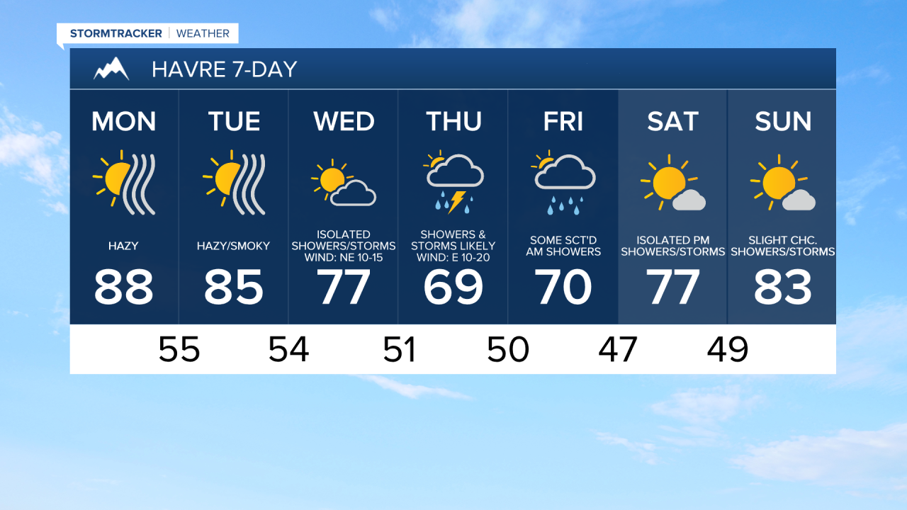
Outside of the wildfire smoke, you can expect mainly sunny skies and dry conditions today and tomorrow as an upper-level ridge remains in control of our weather. It is also going to be very warm today and tomorrow as highs are going to be in the 80s and low 90s. Along the Divide/Rocky Mountain Front, it will be breezy today and tomorrow as sustained wind speeds are going to be between 10 and 20 mph. Elsewhere, there will be a little breeze around today and tomorrow as sustained wind speeds are going to be between 5 and 20 mph.
As we head into the middle and end of the work week, cooler and wetter weather is expected as an upper-level trough is going to be in control of our weather. On Wednesday, highs are going to be in the 70s in most locations. Highs are then going to be in the 60s and low 70s on Thursday and Friday, and these high temperatures are well below average for this time of year. There is also going to be a bit of a breeze around Wednesday afternoon/evening as sustained wind speeds are going to be between 10 and 20 mph.
It is going to be partly to mostly cloudy on Wednesday and there are going to be some isolated showers and thunderstorms around, especially in the mountains and along the Hi-Line. There are then going to be scattered showers and thunderstorms around on Thursday, and as of right now, Thursday will feature the most widespread precipitation over the next week. On Friday, there are going to be some more scattered showers and thunderstorms around, especially during the morning and generally in the mountains and in locations east of I-15. It is also going to be mostly cloudy on these two days.
The temperatures will warm back up this weekend as another ridge begins to build back into our area. Highs on Saturday will be in the 70s and low 80s and highs on Sunday will be in the mid to upper 70s and low to mid 80s. The precipitation chances will continue this weekend as a few showers and thunderstorms are possible on both Saturday and Sunday, mainly during the PM hours and especially in the mountains. It is also going to be partly to mostly sunny this weekend.



Have a marvelous Monday!
Chief Meteorologist Ryan Dennis
