WeatherToday's Forecast

Actions

Hot and hazy with shower and storm chances ahead

Posted

WEATHER DISCUSSION: The day began on a drier note for most of the region until the evening when our first rounds of showers and thunderstorms began to roll in to central portions. Otherwise, high temperatures were seen in the low-70s to mid-90s today with partly sunny skies. Tonight, expect low temperatures in the 50s/60s with mostly cloudy skies and winds dying down to 5 to 10 mph. With several wildfires in and just to our West, lower air quality and reduced visibility will affect portions of the regions at times.

081625 Lows Tomorrow

A few disturbances moving through are the reason for the shower and thunderstorm chances that will be expected through Monday. Scattered afternoon/evening showers/thunderstorms will be possible, starting this evening. At this time, the strength of the daily thunderstorm activity varies from some isolated strong storms, to just a few light showers.

WATCH THE FORECAST VIDEO:

Hot, hazy, and storm chances ahead

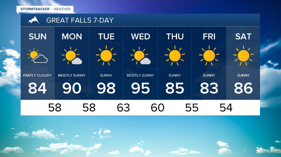
Along with the showers and thunderstorms, afternoon temperatures are expected to be above average most days through Wednesday, with Tue/Wed looking to be the warmest days in the low to upper-90s for some areas. This is thanks to an upper-level ridge and high pressure system that will be dominating the region. However, high temperatures tomorrow on Sunday aren't expected to be as hot as today, but you can still expect temperatures in the upper-70s to low-90s with partly sunny to mostly sunny skies. Hazy conditions are expected to continue tomorrow at times as well.

081625 Highs Tomorrow

On Wednesday, an upper-level trough will approach the region by late in the day, resulting in increased winds over North Central MT. A few showers/thunderstorms will accompany the trough, but the main impact will be for some cooler afternoon temperatures mainly in the 80s starting on Thursday and continuing into next weekend.

081625 GF 7 day
081625 Helena 7 day
081625 Havre 7 day