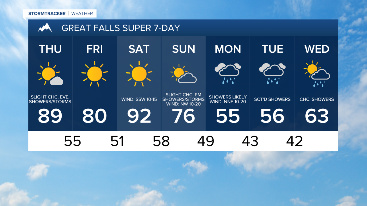
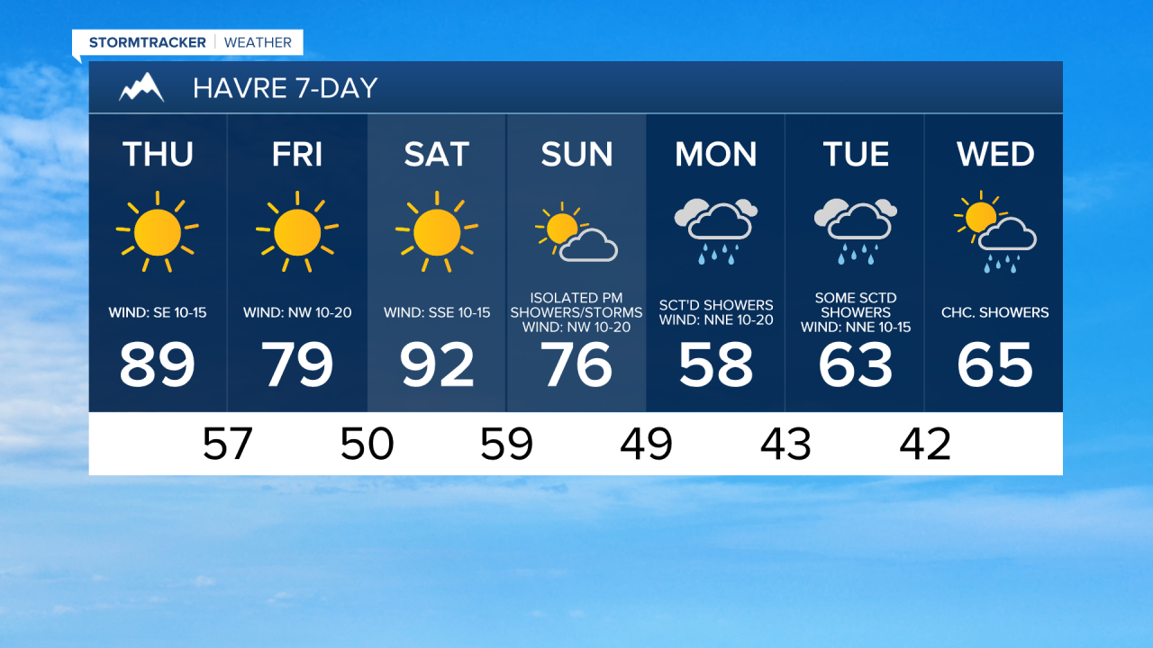
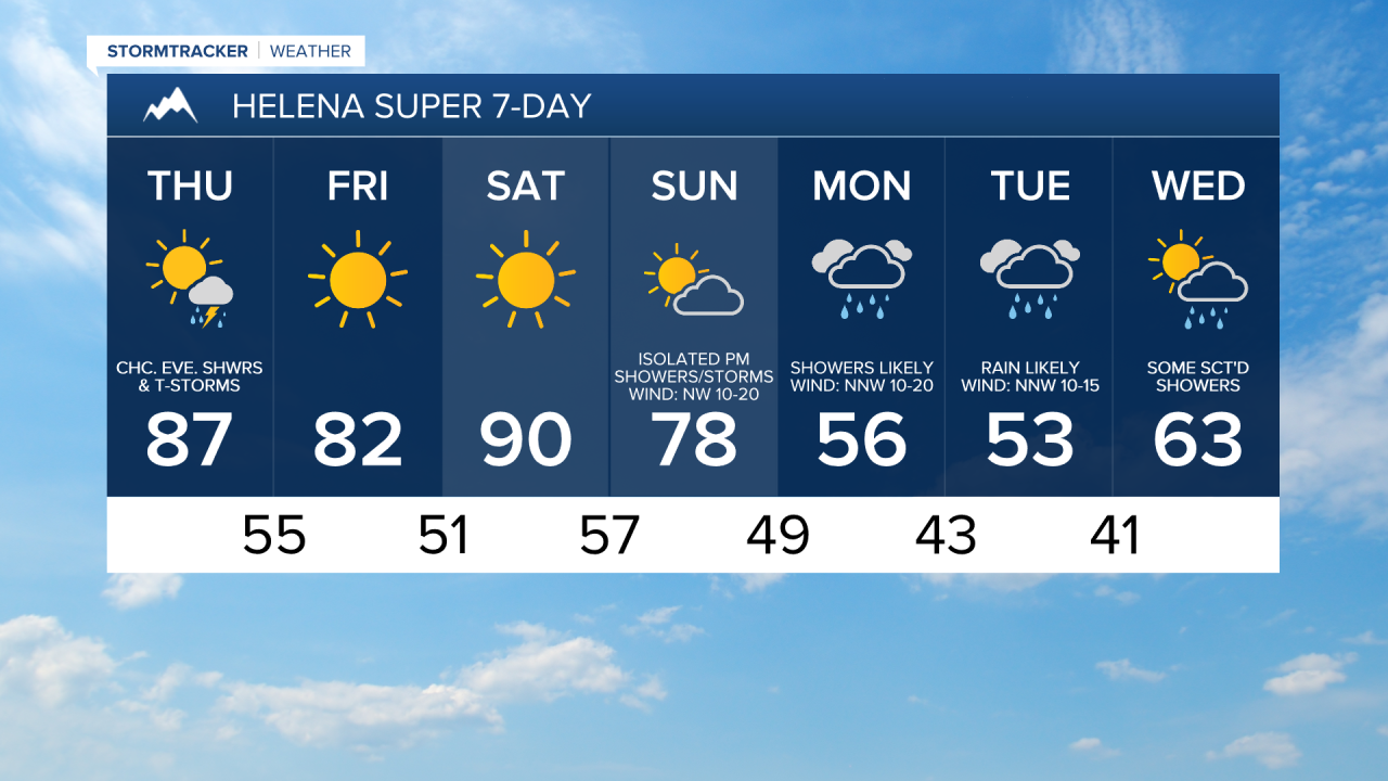
We are going to have clear skies and mild temperatures tonight as lows are going to be in the mid to upper 40s and low to mid 50s in most locations.
For tomorrow, it is going to be even warmer than it was today as highs are going to be in the 80s and low 90s. It is also going to be a bit breezy tomorrow along the Rocky Mountain Front/the Divide, along the Hi-Line, and in eastern portions of north-central Montana as sustained wind speeds are going to be between 10 and 20 mph. We are also going to have lots of sunshine again tomorrow, but the cloud cover will increase around Helena and in western portions of north-central Montana during the afternoon and evening as a weak cold front begins to impact our area.
There are going to be a few showers/storms around Helena tomorrow evening and early tomorrow night, and there are going to be some isolated showers/storms around in north-central Montana tomorrow night (after 8pm) as this cold front passes through our area. Gusty winds (possibly over 50 mph), lightning, small hail, and brief downpours will be the main hazards with these storms.
On Friday, we are going to have mainly sunny skies with a couple showers around in northeastern Montana during the morning. It is also going to be cooler on Friday than it is going to be tomorrow as highs are going to be in the mid to upper 70s and low to mid 80s. There is also going to be a good breeze around on Friday in locations east of I-15 as sustained wind speeds are going to be between 10 and 25 mph, and wind gusts up to 40 mph are possible. This wind coupled with the warm temperatures will elevate the fire danger, so please do your part to not start any new fires.
For many of us, Saturday will be the hottest day of 2025 so far (even hotter than tomorrow) as highs are going to be in the mid to upper 80s and low to mid 90s. These hot temperatures will be accompanied by abundant sunshine and dry conditions. It is also going to be a bit breezy on Saturday as sustained wind speeds are going to be between 10 and 20 mph.
On Sunday, we are going to have increasing clouds with a few PM showers/storms around as a storm system begins to approach our area. We are also going to have a wide range of temperatures on Sunday as highs are going to range from the mid 60s to the mid 80s, with the warmest temperatures in northeastern Montana. Breezy conditions are also expected on Sunday as sustained wind speeds are going to be between 10 and 20 mph.
There are then going to be scattered rain showers and isolated thunderstorms around on Monday and Tuesday in north-central Montana, and rain showers and a couple thunderstorms are likely around Helena on Monday and Tuesday as this storm system slowly passes through our area. There is also going to be some snow in the mountains on these two days. It is also going to be significantly cooler early next week as highs are only going to be in the upper 40s, 50s, and low to mid 60s. There is also going to be a cool breeze around on Monday as sustained wind speeds are going to be between 10 and 20 mph.
Some more scattered showers are possible on Wednesday as this storm system pulls away from our area. We are also going to have partly cloudy skies and warmer temperatures on Wednesday as highs are going to be back in the 60s and upper 50s.