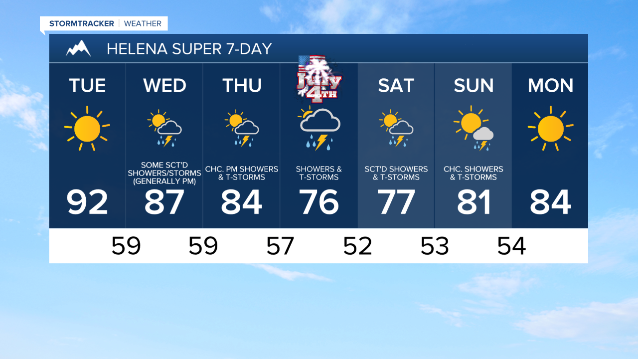
We are going to have clear skies tonight and mainly sunny skies tomorrow as an upper-level ridge is going to continue to be in control of our weather. Dry conditions are also expected tonight and tomorrow, although a couple stray showers/thunderstorms are possible south of Helena tomorrow evening. It will be mild tonight as lows are going to be in the 50s, and it will be hot tomorrow as highs are going to be in the mid to upper 80s and low to mid 90s.
The upper-level ridge will begin to shift eastward as we head into Wednesday and Thursday, giving us southwesterly flow aloft, which will allow some monsoonal moisture to begin to work its way into the state. On Wednesday, we are going to have increasing clouds with some scattered showers and thunderstorms around, mainly during the PM hours. On Thursday, we are going to have increasing clouds with some scattered PM showers/storms around the Helena area and some isolated PM showers/storms around in north-central Montana. A couple severe thunderstorms will also be possible on these two days, with damaging winds being the main hazard, so please keep an eye to the sky if you are going to be outdoors at all!

It will continue to be hot on Wednesday as highs are going to be in the 90s and mid to upper 80s. Thursday will be slightly cooler, but still very warm as highs are going to be in the 80s and low to mid 90s. On both days, the hottest temperatures will be along the eastern half of the Hi-Line. There is also going to be a bit of a breeze around on Wednesday along the Rocky Mountain Front and there is going to be a bit of a breeze around in portions of the plains on Thursday as sustained wind speeds are going to be between 10 and 20 mph.
There are then going to be scattered showers and thunderstorms around on the 4th of July (Friday), especially during the afternoon/evening, and on Saturday as a stronger disturbance passes through our area. Neither day will be a wash-out, but this precipitation may occur during some of the 4th of July events, including the parades and fireworks shows, so keep the rain gear handy. We are also going to have partly to mostly cloudy skies on Friday and a mixture of sun and clouds on Saturday.
Cooler and more seasonable temperatures are also expected on these two days as highs are going to be back in the mid to upper 70s and low to mid 80s. There is also going to be a bit of a breeze around in some areas on Friday as sustained wind speeds are going to be between 10 and 20 mph.
We are then going to have partly to mostly sunny skies on Sunday with some scattered showers and thunderstorms around, especially during the afternoon and evening. We are also going to have near average temperatures again on Sunday as highs are going to be in the mid to upper 70s and low 80s.