There are going to be some scattered rain showers around tonight, generally before midnight and mainly in locations east of I-15, as a disturbance continues to work its way through our area. We are also going to have partly to mostly cloudy skies and chilly temperatures tonight as lows are going to be in the 30s in many locations.
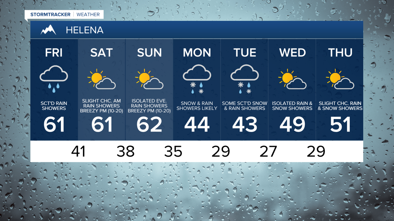
For tomorrow, we are going to have mostly cloudy skies with some scattered rain showers and isolated thunderstorms around, generally during the afternoon and evening, as another disturbance begins to pass through our area. There are then going to some more scattered rain showers around tomorrow night, generally in locations east of I-15, as this disturbance continues to work its way through our area. We are then going to have decreasing clouds with some isolated AM valley rain and mountain rain/snow showers around on Saturday as this disturbance leaves our area.
The temperatures tomorrow and Saturday are also going to continue to be near average for this time of year as highs are going to be in the 60s in most locations. It is also going to be breezy on Saturday, especially during the afternoon and evening, as sustained wind speeds are going to be between 10 and 20 mph.
On Sunday, we are going to have partly cloudy skies with some rain and snow showers around along the Continental Divide as the next storm system begins to approach our area. It is also going to be cool and windy on Sunday as highs are going to be in the low to mid 60s and sustained wind speeds are going to be between 15 and 30 mph.
There are then going to be some scattered rain and snow showers around on Monday as this storm system begins to pass through our area. We are then going to have a chance to see some more snow and rain showers on Tuesday, generally in locations east of I-15, as this storm system begins to leave our area. Now it is still too far out to talk about snow accumulations, but accumulating snow is expected in the higher elevations on these two days, and accumulating snow is *possible* in the lower elevations on these two days, especially in the lower elevation locations that are south and west of Great Falls.
It is also going to be chilly on Monday and Tuesday as highs are only going to be in the 40s in most locations. There is also going to be a bit of a breeze around on both of these days, especially during the PM hours, as sustained wind speeds are going to be between 10 and 20 mph.
We are then going to have partly cloudy skies with some isolated rain and snow showers around on Wednesday, and mostly sunny skies with a slight chance of rain and snow showers on Thursday as we continue to remain in an unsettled weather pattern. It is also going to be a little bit warmer on these two days than it is going to be on Monday and Tuesday as highs are going to be in the upper 40s and low to mid 50s in most locations. Breezy conditions are also expected on Wednesday, especially during the afternoon and evening, as sustained wind speeds are going to be between 10 and 20 mph.