


Happy Wednesday everyone! There were scattered showers and thunderstorms around yesterday and overnight as a wave of monsoonal moisture worked its way through the state. Several of the thunderstorms that developed yesterday evening were severe with damaging winds, large hail, and/or heavy rainfall, which led to localized flash flooding.
Here is today's forecast:
Southern Fergus County was one of the places that was hit the hardest as golf ball to tennis ball sized hail fell around the Hobson area, an 86 mph wind gust was record at N Bar Ranch southwest of Grass Range, and there were downed trees and downed power lines in Lewistown as well as some flooding.


Today will be a much quieter day for central and north-central Montana. There will still be a few showers and thunderstorms around, but a lot of locations will remain dry and no severe weather is expected in our part of the state. It is also going to be partly to mostly cloudy today.
In south-central Montana, it will be another active day of weather as there are going to be some scattered showers and thunderstorms around this afternoon through early tonight, and a few of the thunderstorms that develop may be severe with damaging winds (58+ mph) and/or large hail (1+” in diameter). Heavy rainfall is also possible, which could lead to localized flash flooding, and a FLOOD WATCH is in effect from 12pm today through 3am tonight for a lot of south-central Montana.


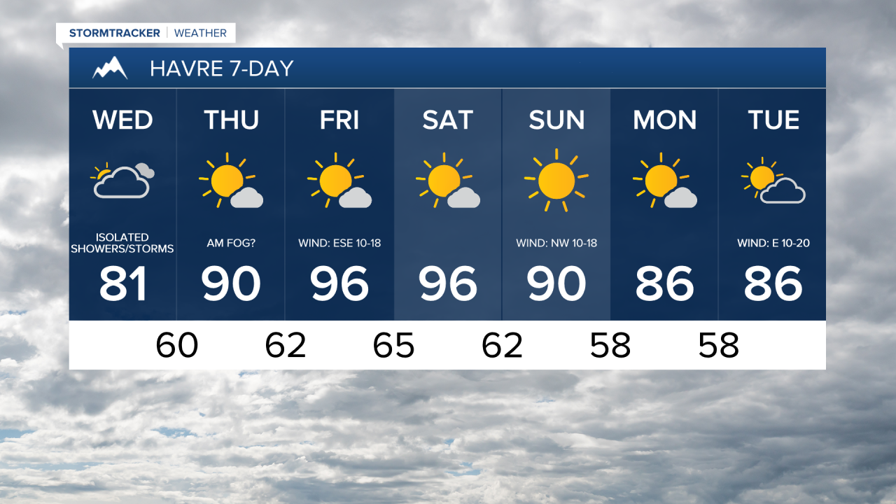
It is going to be warm today, but for a lot of locations, today will be the coolest day since last week as highs are only going to be in the mid to upper 70s and low to mid 80s. There is also going to be little to no wind around today.
The temperatures will warm back up for the end of the work week as highs tomorrow are going to be in the 80s and low 90s and highs on Friday are going to be in the mid to upper 80s and low to mid 90s.
In north-central Montana, there will be a few areas of fog around tomorrow and Friday morning, especially in the Golden Triangle. Outside of the fog, you can expect mostly sunny skies, with the cloud cover increasing during the PM hours. A lot of locations will remain dry the next two days, but there will be a few showers and thunderstorms around each afternoon and evening, especially in western and southern portions of north-central Montana.
Around Helena, it is going to be partly to mostly sunny tomorrow and Friday, with the cloud cover increasing as the day goes on. There are also going to be some scattered showers and thunderstorms around tomorrow afternoon/evening and Friday afternoon/evening as some more monsoonal moisture works its way into the state.
Some of the thunderstorms that develop later tomorrow in central and western Montana may be severe with damaging winds (58+ mph) and/or large hail (1+" in diameter). Heavy rainfall is also possible, which could lead to localized flash flooding.

Scattered showers and thunderstorms are expected Friday night as another wave of monsoonal moisture passes through the state. Most of this precipitation should be out of here by sunrise on Saturday.
This weekend will be another hot one, but not quite as hot as last weekend was, as highs are going to be in the 90s and upper 80s on Saturday and the upper 80s and low to mid 90s on Sunday. On Saturday, it is going to be mostly sunny with a few showers and thunderstorms around during the afternoon and evening. Lots of sunshine and dry conditions are then expected on Sunday. There is also going to be a little breeze around this weekend as sustained wind speeds are going to be between 5 and 20 mph.
The temperatures will cool back down into the 80s for the beginning of next week. Monday will be mostly sunny and mainly dry. A few showers and thunderstorms are then possible on Tuesday as a disturbance passes through our area. It is also going to be partly to mostly cloudy on Tuesday. There is also going to be a little breeze around early next week as sustained wind speeds are going to be between 5 and 20 mph.


Have a wonderful Wednesday!
Chief Meteorologist Ryan Dennis
