



Good Morning! Today is Monday, October 12, 2026. Here is today’s forecast:
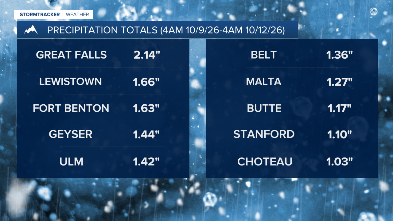
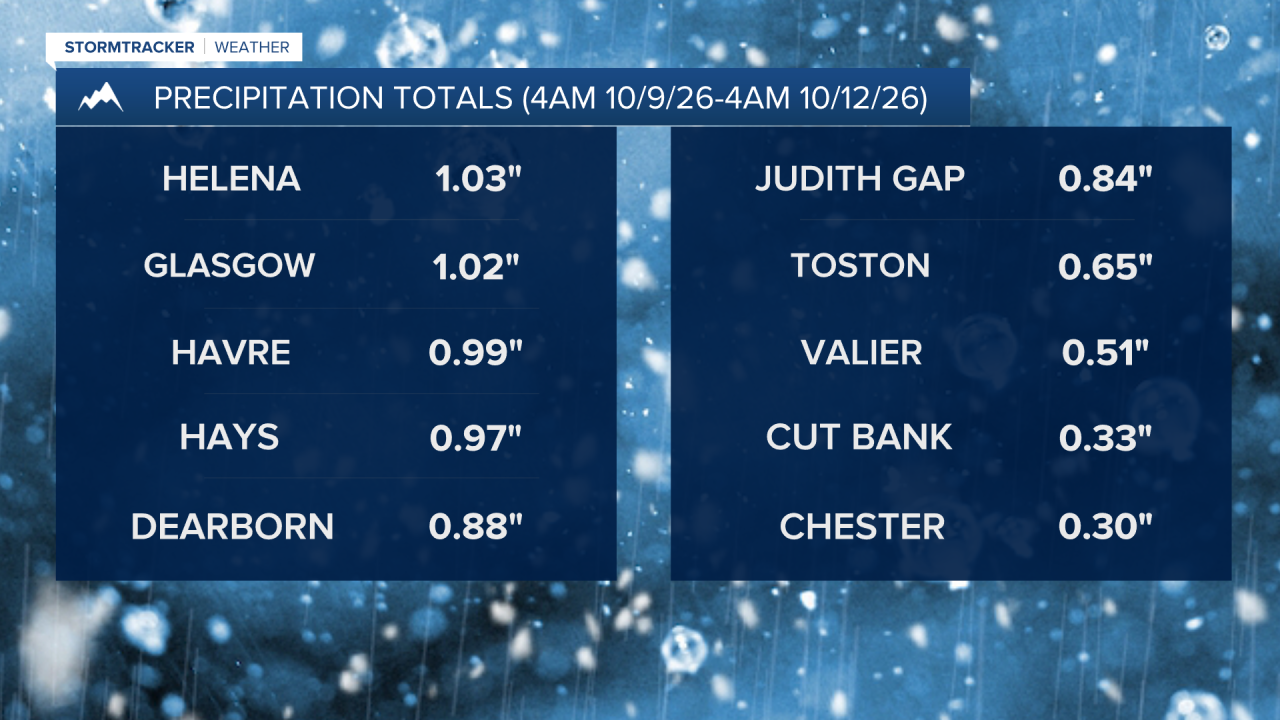
A strong storm system brought widespread precipitation and significantly colder temperatures to the state over the weekend. Highs went from the 70s and 80s on Friday to the 30s and 40s on Sunday. There were several areas that received around or over 1” of moisture this weekend, including Great Falls and Helena. The below graphics show the precipitation totals (rain and the liquid equivalent of the snow) as of 4am Monday.
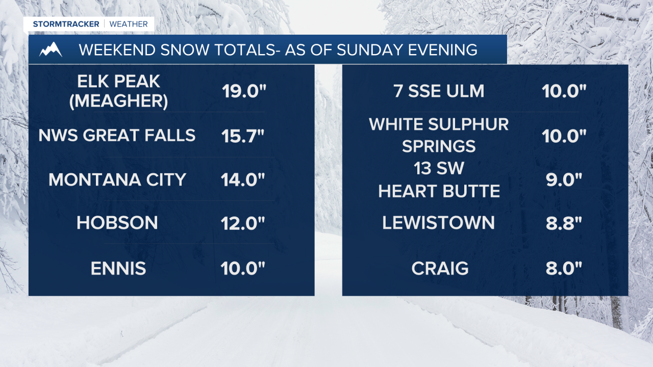
The precipitation this weekend was in the form of rain and snow. The snow that fell was heavy and wet, which did lead to some damage, with multiple downed trees and branches reported. There were also multiple power outages due to the snowstorm. Snow totals ranged from a skiff to over a foot of snow, with the highest snow amounts in the central part of the state, including in Cascade, Fergus, and Judith Basin Counties, as well as around the Helena area. The below graphic shows some of the reported snow totals as of Sunday evening.
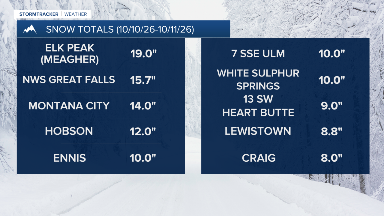
Great Falls broke multiple records this weekend thanks to this storm. Saturday was the wettest October 10th on record, with 1.29” of precipitation being recorded. Saturday was also the snowiest October 10th on record, with 6.4” of snow. Sunday was the snowiest October 11th on record and the snowiest October day on record, with 9.3” of snow. The weekend snow total for Great Falls was 15.7”, which is about 37% of the snow that was received all of last winter!


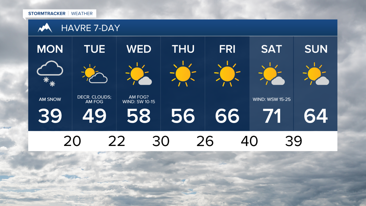
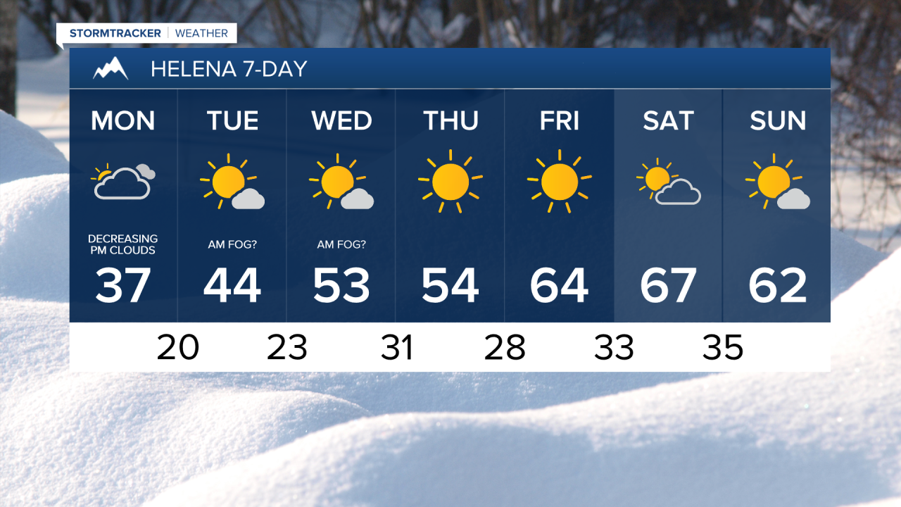
Roads are slick in a lot of areas this morning, so please use caution when driving and give yourself some extra time to get to where you need to go. There are also some areas of fog around. Today will be mostly cloudy to overcast, with the cloud cover diminishing some during the afternoon and evening. There will be some snow around this morning along the eastern half of the Hi-Line, but that snow will taper off as the morning goes on. Elsewhere, it will be mostly dry today, just a few isolated snow showers and scattered flurries around. It will also be cold again today with highs in the 30s and low 40s.
The warming trend begins tomorrow as highs climb back into the 40s and low 50s. There will be areas of fog and low-level stratus clouds around tomorrow morning, but the fog will burn off and the clouds will clear out as the day goes on, with plenty of sunshine expected during the afternoon and evening.
Wednesday will be a mostly sunny day, with some areas of fog around during the morning. It will also feel nice outside on Wednesday as highs will be back in the upper 40s and low to mid 50s.
Nice weather is expected Thursday through Sunday as an upper-level ridge will be in control of our weather. Lots of sunshine and dry conditions are expected Thursday and Friday, while the weekend will feature partly to mostly sunny skies and dry conditions. Thursday will be another cool day with highs in the low to mid 50s. Much warmer temperatures will return for Friday and the weekend as highs will be in the 60s and low 70s.
There will be little to no wind Thursday and Sunday. Friday will be breezy in some areas with sustained winds of 10 to 25 mph. Saturday will be a gusty day with sustained winds of 10 to 30 mph, and gusts up to 40 mph are possible.


Have a great week!
Chief Meteorologist Ryan Dennis
