


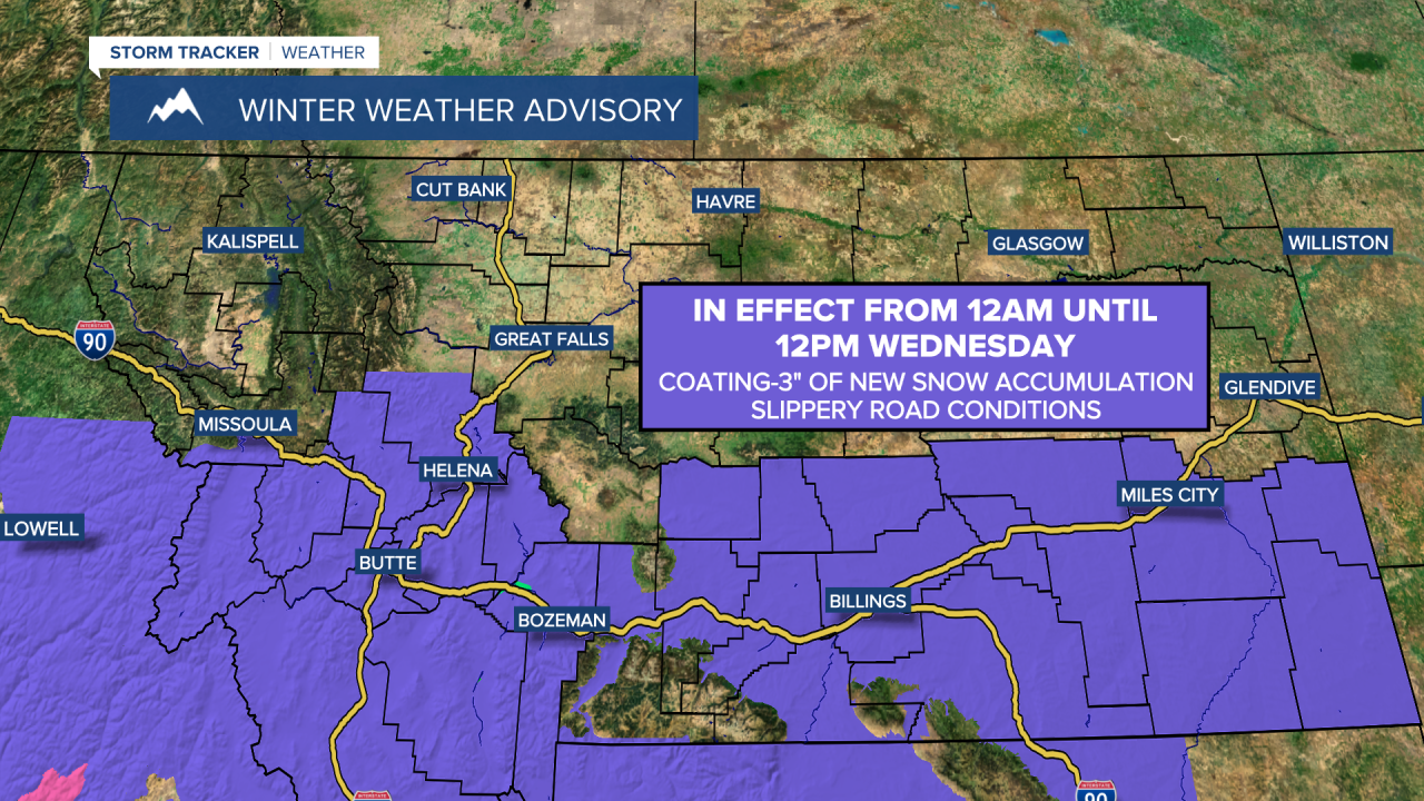
A Winter Weather Advisory is in effect for south-central and southwestern Montana from 12am until 12pm on Wednesday. New snow accumulation of a coating to 3 inches is expected in locations that are under this advisory.
A Winter Weather Advisory is in effect for portions of central Montana from 6am until 10pm on Thursday. New snow accumulation of 3 to 7+ inches is expected in locations that are under this advisory.
A Winter Storm Watch is in effect for the Rocky Mountain Front from 6am Thursday until 12am Saturday. 3 to 12+ inches of new snow accumulation is expected in locations that are under this watch. Blowing and drifting snow is also going to create hazardous driving conditions, especially late Thursday night and during the day on Friday.

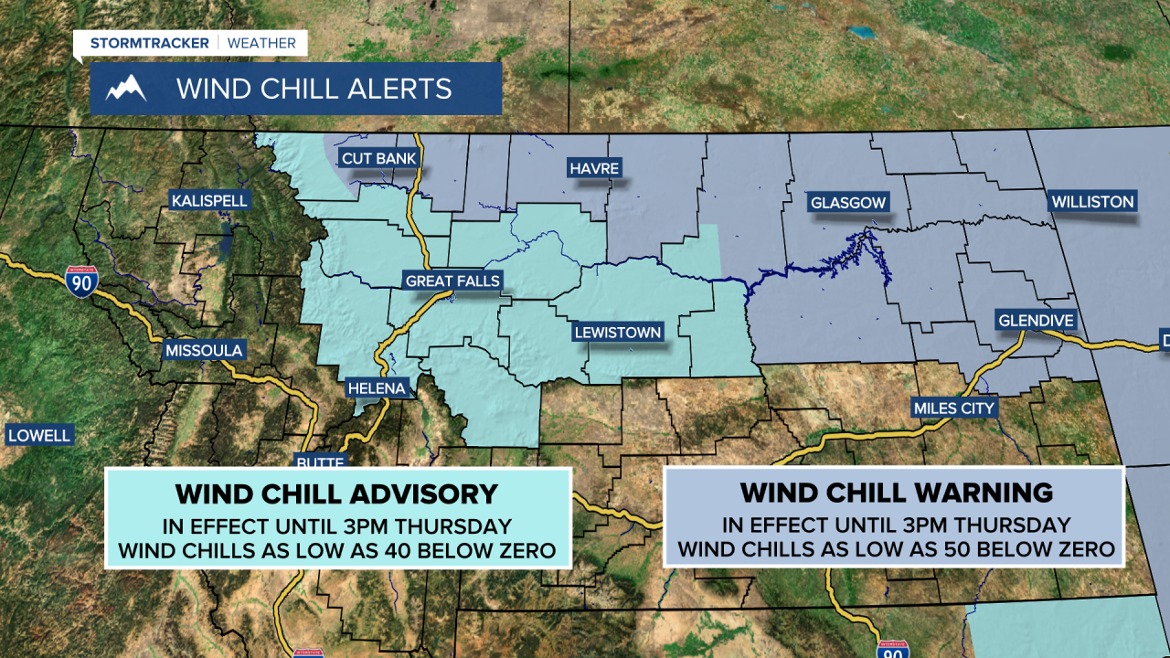
A Wind Chill Warning is in effect for the Hi-Line until 3pm Thursday, and a Wind Chill Advisory is in effect for the rest of central Montana until 3pm Thursday. Wind chills as low as 50 below zero are possible along the Hi-Line, while wind chills as low as 40 below zero are possible in the rest of central Montana. With wind chills this low, frostbite can occur on exposed skin in as little as 5 to 15 minutes.
There are going to be some scattered snow showers around tonight as a weak disturbance begins to pass through our area. Up to 2 inches of new snow accumulation is possible in locations that see this snow. It is also going to be frigid tonight as lows are going to be in the -20s and -10s in a lot of locations, and wind chills may get as low as 40 to 50 below zero in spots. We are also going to have partly to mostly cloudy skies tonight.
For tomorrow, we are going to have partly to mostly cloudy skies with a slight chance of snow showers in north-central Montana. Around Helena, there are going to be scattered areas of snow around tomorrow as a disturbance leaves our area. New snow accumulation of a coating to 3 inches is expected in and around Helena. It is also going to be very cold tomorrow as highs are only going to be in the -10s and -0s, and wind chills as low as 40 to 50 below zero are going to be possible at times.
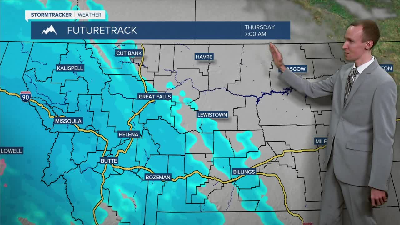
Tomorrow night is going to start off dry, but snow is going to start to work its way into central Montana after midnight. Widespread snow is then expected on Thursday, and this snow may be heavy at times. In some locations, this is going to be the biggest snowfall that we have had so far this winter as 3 to 7 inches of snow accumulation is expected in portions of central Montana, including Helena and Great Falls. The further north and east of Great Falls you go, the lower the snow amounts are going to be with a general 1 to 4 inches of snow accumulation expected by 7am Friday. On the other hand, the further south and west of Helena you go, the higher the snow amounts are going to be with some spots picking up over 12 inches of snow, and the highest snow amounts are expected in the Rockies. This snow is going to create slippery road conditions in the lower elevations and hazardous to dangerous driving conditions in the higher elevations, especially in the Rockies, so please be careful when driving and give yourself plenty of extra time to get to where you need to go.


We are also going to have a wide range of temperatures on Thursday as a warm front begins to pass through our area. Along the Hi-Line, highs on Thursday are going to be around or below zero, while around Helena highs are going to be in the low to mid 30s. Around Great Falls, highs are going to top out in the teens.
On Friday, we are going to have cloudy skies with some scattered snow and rain showers around as this warm front leaves our area and as a cold front begins to approach and pass through our area. It is also going to be warmer on Friday than it is going to be over the next couple of days as highs in a lot of locations are going to be in the 20s and 30s, and a few locations are going to top out in the 40s. Breezy conditions are also expected on Friday as sustained wind speeds are going to be between 10 and 20 mph. This wind is going to cause there to be areas of blowing and drifting snow, which may create dangerous travel conditions, especially along the Rocky Mountain Front where even stronger winds are expected.
Colder temperatures are then expected on Saturday as highs are going to be back in the single digits and teens in north-central Montana, while highs in Helena are going to be around freezing. We are also going to have partly cloudy skies on Saturday with some isolated snow showers around, generally during the morning.
Mostly sunny skies and dry conditions are then expected on Sunday and Monday as high pressure is going to be in control of our weather. We are also going to have seasonable temperatures on these two days as highs are going to be in the 20s and low 30s on Sunday and the 30s on Monday. It is also going to be breezy in north-central Montana on these two days as sustained wind speeds are going to be between 10 and 20 mph.


