


There have been scattered rain and snow showers around throughout the day today and there will continue to be scattered rain and snow showers around this evening and tonight, especially before midnight and generally in central Montana and western portions of north-central Montana, as a storm system continues to impact the state.
Here is the detailed forecast:
The mountains may receive another 1-5” of snow through tomorrow morning. In the lower elevations, up to an inch of snow is possible, but most locations will receive little (a coating) to no snow accumulation through tomorrow morning. In the lower elevations, roads may be slick in some areas tonight and tomorrow morning due to moisture on the roadways freezing overnight, so use caution when driving.

It is going to be chilly tonight as lows are going to be in the 20s and low 30s. It is also going to be a little breezy in some areas tonight as sustained wind speeds are going to be between 5 and 20 mph. Mostly cloudy skies are also expected tonight, with the skies clearing out some as we approach sunrise.
Tomorrow will be partly to mostly sunny and mostly dry, just a few isolated snow and rain showers around, generally in the mountains. Along the Rocky Mountain Front, it is going to be gusty tomorrow as sustained wind speeds are going to be between 15 and 30 mph, and gusts over 50 mph are possible. East of the Rocky Mountain Front, it is going to be breezy tomorrow as sustained wind speeds are going to be between 10 and 25 mph, and gusts up to 40 mph are possible. It is also going to be cool tomorrow as highs are going to be in the 40s and low 50s in most locations.
This weekend will be a windy one as gusts of 65-85+ mph are possible along the Rocky Mountain Front and gusts of 50-60+ mph are possible east of the Rocky Mountain Front. Along the Rocky Mountain Front, sustained wind speeds this weekend are going to be between 25 and 50 mph. East of the Rocky Mountain Front, sustained wind speeds this weekend are going to be between 15 and 40 mph. The strongest wind will be on Sunday.
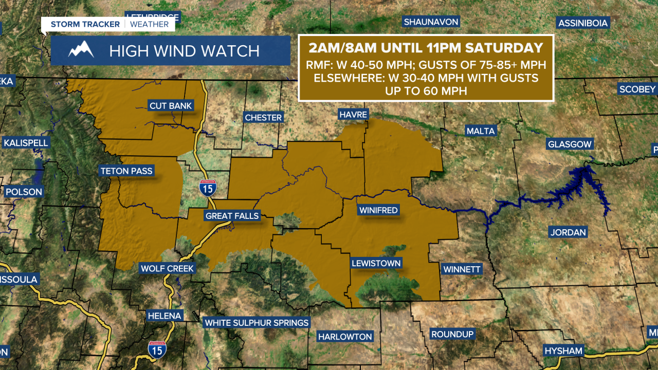
A HIGH WIND WATCH is in effect for the Rocky Mountain Front and portions of the plains from 2am/8am until 11pm Saturday. A HIGH WIND WATCH will also likely be issued for Sunday later tonight or tomorrow morning. In the Helena valley, it will be breezy on Saturday as sustained wind speeds are going to be between 10 and 20 mph, and it will be windy on Sunday as sustained wind speeds are going to be between 15 and 30 mph.
It is also going to be mild this weekend as highs are going to be in the 50s and low to mid 60s in most locations. Saturday will be partly to mostly cloudy and mostly dry, just a few isolated rain and snow showers around, generally in the mountains. On Sunday, it is going to be mostly cloudy with a chance of PM rain and snow showers along the Hi-Line and in the mountains as a cold front begins to approach our area.
A wetter and cooler weather pattern is expected next week. On Monday, there are going to be some scattered rain and snow showers around as a cold front passes through our area. It is also going to be colder on Monday as highs are going to be in the mid to upper 30s and low to mid 40s. Windy conditions are also expected on Monday as sustained wind speeds are going to be between 15 and 35 mph, and wind gusts over 50 mph are possible.
There are then going to be some scattered snow showers around on Tuesday and a few scattered snow and rain showers around on Wednesday as a couple more disturbances pass through the state. It is also going to be partly to mostly cloudy and chilly on these two days as highs are going to be in the 30s and low to mid 40s. Gusty winds are also expected on these two days as sustained wind speeds are going to be between 10 and 30 mph.
A stronger disturbance will then bring more scattered rain and snow showers to the state on Thursday. It is also going to be gusty and warmer on Thursday as sustained wind speeds are going to be between 10 and 30 mph and highs are going to be in the 40s and low 50s.


