


Good Morning and Happy Tuesday! It is going to be an active day of weather as a cold front approaches our area and as a jet streak passes overhead. The wind will increase as we go through this morning, and it will be windy later this morning through this evening in western and central portions of north-central Montana as well as around the Helena area. Sustained wind speeds are going to be between 15 and 35 mph, and wind gusts of 40-60+ mph are expected.
Here is today's forecast:
A HIGH WIND WARNING is in effect for the Rocky Mountain Front, the Hi-Line between the Divide and I-15, part of Judith Basin County, and some of the higher terrain in central Montana from 12pm today until 12am tonight as gusts up to 65 mph are possible in these locations.

A LAKE WIND ADVISORY is also in effect for Fort Peck Lake from 1pm today until 8pm Wednesday as gusts up to 45 mph are possible.

The wind won’t be as strong in eastern portions of north-central Montana today, but it will still be gusty later on as sustained wind speeds will be between 10 and 25 mph, and wind gusts up to 40 mph are possible. The wind will diminish some overnight. Tomorrow, the strongest wind will be in eastern portions of north-central Montana as sustained wind speeds are going to be between 15 and 30 mph, and wind gusts over 50 mph are possible. Elsewhere, the wind will be weaker tomorrow than it will be today, but it will still be breezy with 10-25 mph sustained winds and gusts up to 40 mph.
The wind today will be coming out of the west and it will make travel difficult for high-profile vehicles and vehicles pulling trailers, especially on north-south oriented highways. The wind tomorrow will be coming out of the northwest, so it will be a cooler wind.
It is going to be warm today as highs are going to be in the upper 70s and low to mid 80s in most locations. This warmth combined with the gusty to strong winds will elevate the fire danger, so please do your part to not start any new fires. A cold front will pass through Montana later today and tonight, which will cool our temperatures back down into the mid to upper 60s and low 70s tomorrow.
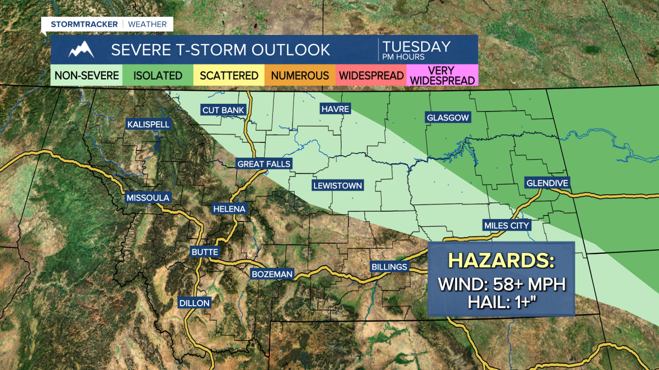
It is going to be mostly sunny and dry today around Helena. In north-central Montana, it is going to be partly to mostly sunny today with a few showers in northeastern Montana early this morning and a few showers and thunderstorms around late this afternoon and this evening, generally along the Hi-Line east of I-15, as a cold front begins to pass through our area. A couple of the thunderstorms that develop later on today in northeastern Montana may be severe with damaging winds (58+ mph) and/or large hail (1+” in diameter).
There will be some scattered showers and thunderstorms around tonight, generally in locations east of I-15, as a cold front continues to pass through our area. Tomorrow will be partly to mostly sunny with some scattered showers and thunderstorms around in north-central Montana, generally during the afternoon and evening, and some isolated showers and thunderstorms around the Helena area, generally during the afternoon and evening.
On Thursday, it is going to be mostly sunny and dry around Helena. In north-central Montana, it is going to be partly to mostly sunny and there will be a few showers and thunderstorms around, generally during the afternoon and evening. It is also going to feel nice outside on Thursday as highs are going to be in the mid to upper 60s and low to mid 70s and there is only going to be a little breeze (5-20 mph).
Friday will be a beautiful day as high pressure will briefly be in control of our weather. On Friday, it is going to be partly to mostly sunny, dry, and mild as highs are going to be in the 70s and low 80s. There is also only going to be a little breeze around on Friday as sustained wind speeds are going to be between 5 and 20 mph.
It will be partly to mostly cloudy on Saturday and there will be some scattered showers and thunderstorms around, generally during the PM hours and especially in central Montana and in the mountains, as a disturbance passes through our area. There will then be a few more scattered showers and thunderstorms around on Sunday, generally in the mountains and in locations east of I-15, as another disturbance impacts the state. It is also going to be partly cloudy on Sunday.
It will remain mild this weekend, but the temperatures will cool down a little bit, as highs are going to be in the 70s on Saturday and the upper 60s and low to mid 70s on Sunday. There is also going to be a breeze around this weekend as sustained wind speeds are going to be between 10 and 20 mph, and wind gusts over 30 mph are possible.


Have a terrific Tuesday!
Chief Meteorologist Ryan Dennis
