


We had beautiful spring-like weather again today with mostly sunny skies and mild temperatures as highs were in the 50s in a lot of locations. Winter returns tomorrow though as a cold front is going to bring rain/snow, gusty to strong winds, snow squalls, and falling temperatures to our area.
Here is the detailed forecast:
A WINTER WEATHER ADVISORY is in effect for the Rocky Mountain Front and the Hi-Line from the Rocky Mountain Front to the Liberty/Hill County line from 2am tomorrow until 5pm/8pm tomorrow and for most of Hill County and northern Blaine County from 11am until 11pm tomorrow. A WINTER STORM WATCH is in effect for most of northeastern Montana from 5pm tomorrow until 11am Wednesday.


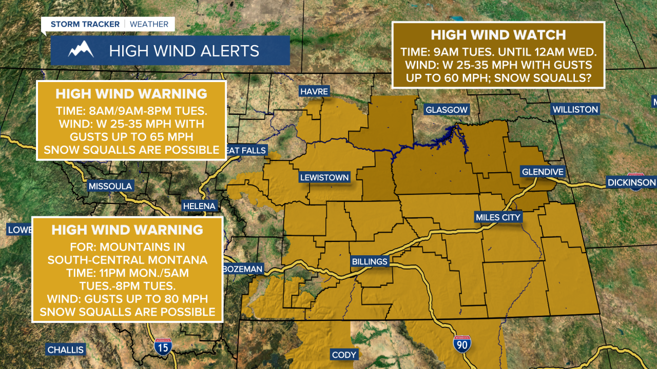
There is also a HIGH WIND WARNING in effect for portions of north-central Montana east of I-15 from 8am/9am until 9pm tomorrow and there is a HIGH WIND WATCH in effect for portions of northeastern Montana from 9am tomorrow until 12am Wednesday.
The cloud cover will increase tonight with some scattered rain and snow showers developing after midnight around Helena and in western portions of north-central Montana. Precipitation is then likely tomorrow with this precipitation moving east/northeastward as the day goes on. The precipitation may initially start out as rain in some areas, but this rain will mix in with and switchover to snow, especially after the cold front passes through. Precipitation will gradually taper off from west/southwest to east/northeast as the day goes on, and skies will start to clear out some later in the day around Helena.
Snow squalls are possible tomorrow, so use extreme caution when driving. The morning commute tomorrow may also be difficult in some areas around/west of I-15 and the evening commute tomorrow may be difficult in eastern portions of north-central Montana due to low visibility and slick/snow-covered roads.
Snow will gradually end as we go through tomorrow night in northeastern Montana. Through Wednesday morning, up to 6” of snow is possible in the lower elevations and up to 12” of snow is possible in the mountains. The highest snow amounts in the lower elevations will be along the Hi-Line and along the Rocky Mountain Front and out to I-15. How much of the initial precipitation falls as rain versus snow will impact snow amounts, so if the transition from rain to snow takes longer than expected, snow amounts will be lower than forecasted, whereas if the transition occurs quicker than forecasted, then snow amounts may be higher than forecasted. Regardless, roads will be slippery in some areas tomorrow and tomorrow night, so please be careful when driving.

It is going to be breezy in some areas tonight as sustained wind speeds are going to be between 10 and 20 mph. It is also going to be cool tonight as lows are going to be in the mid to upper 20s and low to mid 30s. Highs tomorrow will be in the 30s and upper 20s, but the highs will occur during the morning, with falling temperatures throughout the afternoon and evening. Widespread gusty to strong winds are also expected tomorrow as sustained wind speeds are going to be between 10 and 30 mph, and gusts between 40 and 60 mph are possible. The wind direction will also shift from the west/southwest to the west/northwest as the day goes on.
Wednesday will be a bitterly cold day as highs are only going to be in the single digits and low to mid teens, a good 40-50° colder than today. It is also going to continue to be breezy on Wednesday as sustained wind speeds are going to be between 10 and 25 mph, and wind gusts up to 40 mph are possible. The strongest wind will be in northeastern Montana. It will also be mostly cloudy on Wednesday with scattered snow showers around Helena, generally during the afternoon and evening, and a few scattered snow showers in north-central Montana, generally during the afternoon and evening.
Thursday will be cold, but warmer as highs are going to be in the teens and low to mid 20s. It is also going to be partly cloudy on Thursday with a few snow showers around, mainly in the mountains and in locations east of I-15. The wind will also be weaker on Thursday, although it will still be a little breezy as sustained wind speeds are going to be between 5 and 20 mph.
The warm-up continues on Friday as highs are going to be back in the 20s and low 30s. It is also going to be partly to mostly cloudy on Friday with a few snow showers around as another disturbance impacts the state.
Nice weather is expected this weekend as high pressure is going to be in control of our weather. It is going to be mainly dry this weekend with partly to mostly sunny skies on Saturday and partly to mostly cloudy skies on Sunday. It is also going to be chilly this weekend as highs are going to be in the 20s and low to mid 30s. There is also going to be a little breeze around this weekend as sustained wind speeds are going to be between 5 and 20 mph.


