


Good Morning! Today is Wednesday, September 9, 2026. Here is today’s forecast:
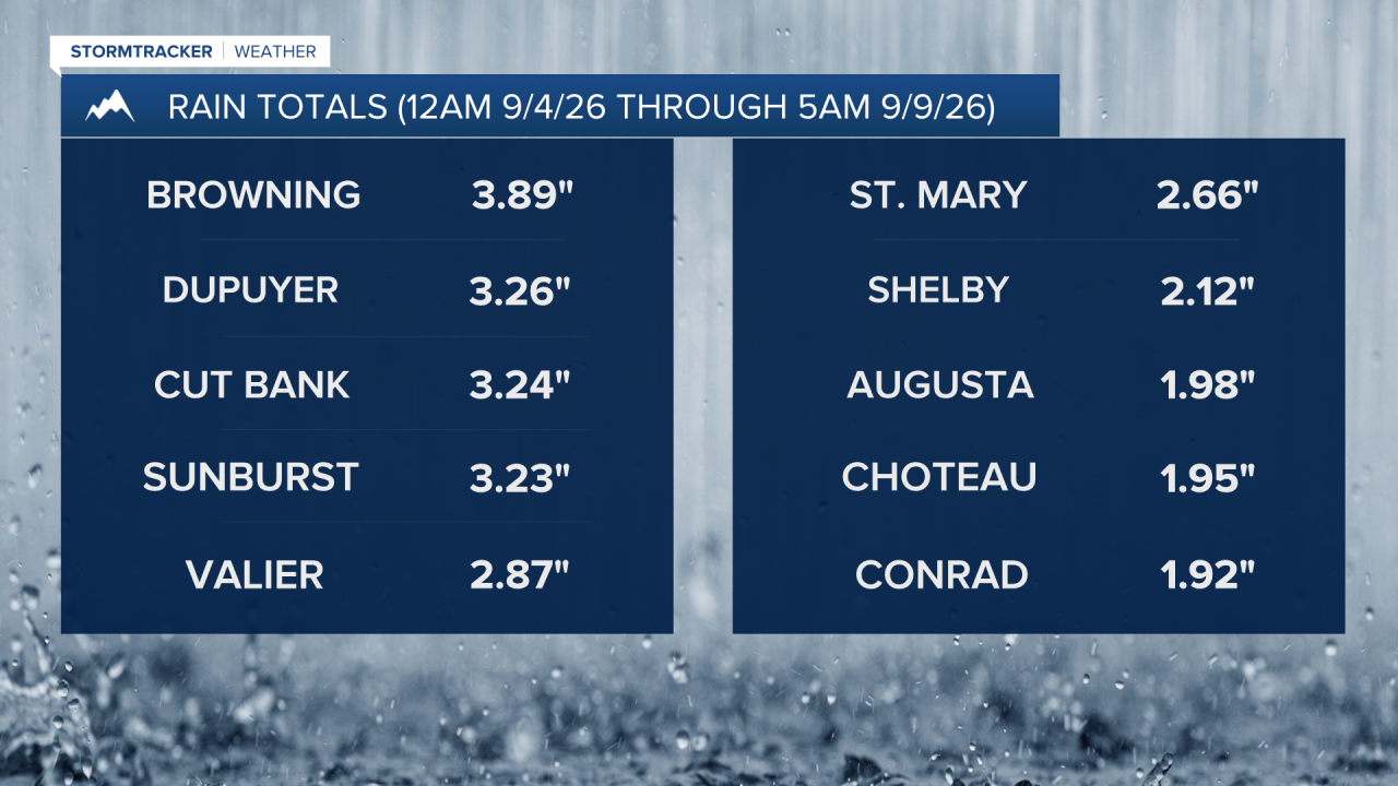
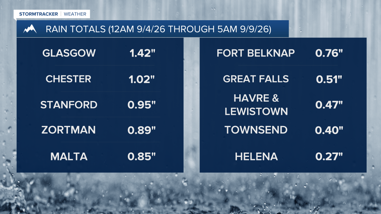
There has been plenty of moisture across portions of Montana over the past several days as a slow-moving storm system gradually worked its way through the state. The Rocky Mountain Front and the Golden Triangle were the biggest beneficiaries, with most locations receiving at least 1 inch of rain and some areas, including Cut Bank and Browning, picking up more than 3 inches. Elsewhere, rainfall totals generally ranged from a quarter inch to an inch.
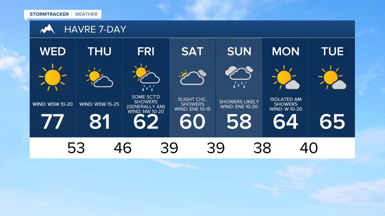
Today will be a beautiful day and the nicest day of the week, so take advantage of it and spend some time outdoors. Expect mostly sunny to sunny skies, dry conditions, and mild temperatures, with highs in the 70s. It will be gusty along the Rocky Mountain Front, where wind gusts could exceed 40 mph at times. Elsewhere, it will be breezy today with sustained winds of 10 to 20 mph.
Tomorrow will be partly to mostly sunny, mostly dry, and warm, with highs climbing into the mid to upper 70s and low to mid 80s. Widespread gusty to strong winds are also expected tomorrow. Along the Rocky Mountain Front, sustained winds will range from 20 to 40 mph and gusts of 50 to 60 mph are possible. East of the Rocky Mountain Front, sustained winds will range from 10 to 30 mph and gusts of 40 to 50 mph are possible.
A cold front will move through late Thursday night into Friday morning, bringing scattered showers and a return to cooler temperatures. Highs on Friday will only reach the mid to upper 50s and low to mid 60s. Skies will be partly to mostly cloudy, and it will be a little breezy, with sustained winds between 5 and 20 mph.
Another storm system is expected to impact Montana this weekend. Saturday will be mostly cloudy to overcast, with some scattered showers developing during the afternoon and evening, primarily across central Montana and western portions of north-central Montana. Precipitation will become more widespread Saturday night, and Sunday looks wet with showers likely throughout the day. A few isolated thunderstorms are also possible.
In the mountains, temperatures will be cold enough for accumulating snow Saturday night and Sunday, with snow levels potentially dropping to pass level, around 5000 to 6000 feet. Some of the higher peaks in the Rockies could receive up to a foot of snow. Temporary closures of Going-to-the-Sun Road and the Beartooth Highway are possible.
It will be cool this weekend, with highs mainly in the 50s and low 60s. Breezy conditions are also expected, especially from Saturday afternoon through Sunday morning, with sustained winds of 10 to 25 mph.
On Monday, skies will gradually clear as the weekend storm system exits the region. A few lingering morning showers are possible east of I-15, but most locations will remain dry. Temperatures will begin to rebound, with highs in the upper 50s and low to mid 60s. It will also be breezy, with sustained winds of 10 to 20 mph.
Tuesday looks pleasant, featuring mostly sunny skies, dry conditions, and cool but comfortable temperatures. Highs will be in the upper 50s and low to mid 60s.



Have a wonderful Wednesday!
Chief Meteorologist Ryan Dennis
