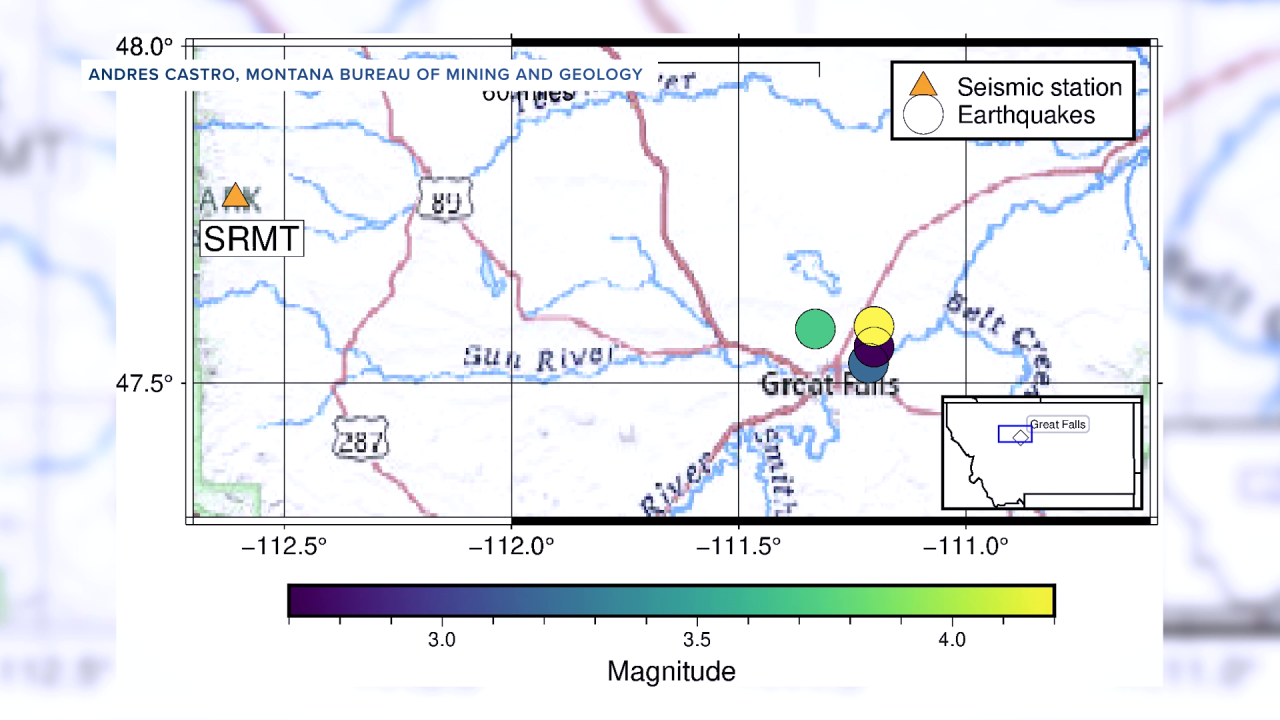


GREAT FALLS — Four earthquakes in recent days have rattled some nerves in and around the region. A 4.2 quake shook the region on Thursday, January 29, 2026. It was followed by a smaller quake of 2.7 later that evening, a 3.2 on January 31, and a 3.7 on February 12. The three smaller quakes were aftershocks of the larger initial quake. There have been no injuries, no serious damage, and no impacts on infrastructure reported in any of the incidents.
But the shaking has some people wondering: are they connected, and should we expect more? Madison Collier reports - watch the video here:
According to Andres Castro, a research seismologist with the Montana Bureau of Mines & Geology, the recent activity near Great Falls appears to be within the normal range of seismic behavior for the state.
“The three earthquakes that occurred about a week, a week and a half ago, are clearly part of an aftershock sequence,” Castro said.
However, he explained that the most recent event, which occurred slightly farther away, could be part of the same sequence or related to a separate nearby fault, and that determination takes time and detailed analysis.
He noted that while earthquakes happen on faults, identifying exactly which fault, or how many are involved, isn't as simple as it seems. In many cases, earthquakes occur along faults that are not visible at the surface.
“That’s actually very common,” he said. “Sometimes we don’t see the faults mapped at the ground surface.”
A waveform graphic from a monitoring station illustrates the vertical ground motion recorded during the earthquake that occurred on January 29th, with the shaking lasting just seconds before tapering off.

While some residents in the area have questioned the recent activity, Castro said it is not unprecedented.
“The level of activity is within the normal range of seismic behavior in Montana,” he explained.
Although he says most earthquakes in Montana occur along the Intermountain Seismic Belt in the western part of the state, central Montana is not exempt.
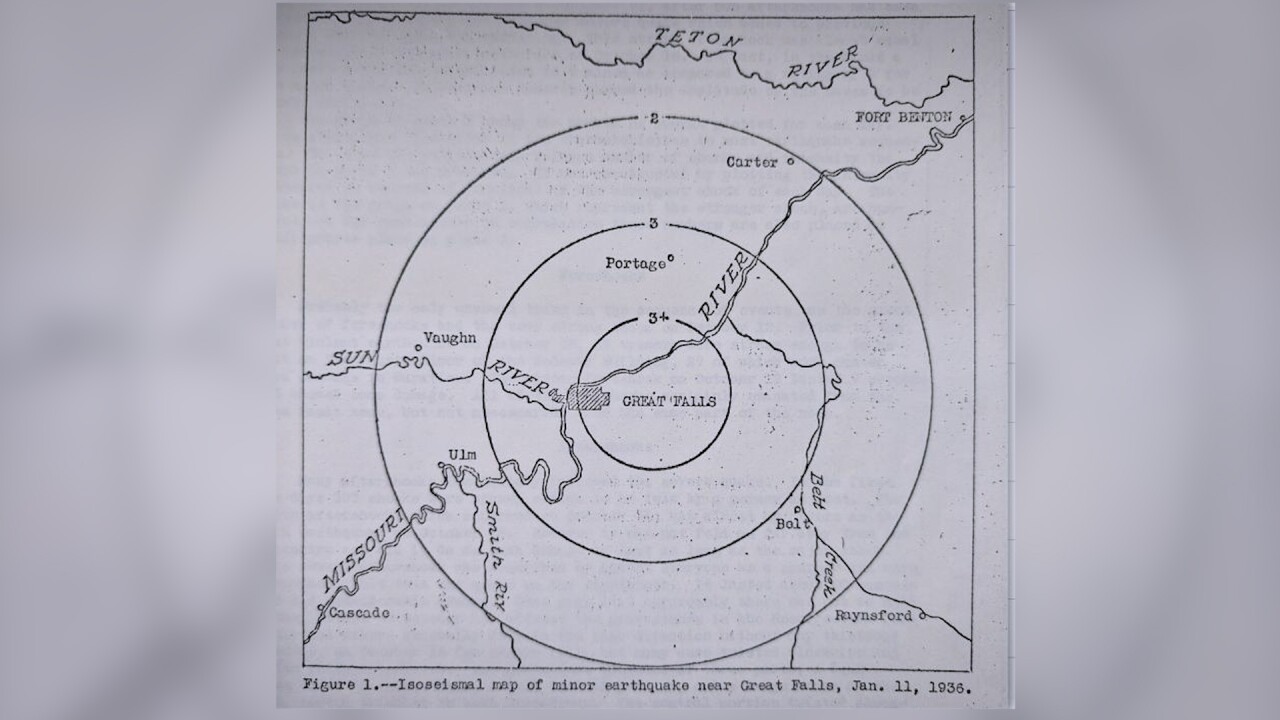
Historical records indicate an earthquake near Great Falls on January 11, 1936, that generated noticeable shaking.
The recent earthquakes occurred at depths ranging from approximately 6 to 13 miles below the surface. That depth range tells seismologists that the rocks in this part of Montana are still behaving in interesting ways at those depths, meaning they fracture and slip along faults rather than slowly deform.
The bureau website notes: "Although it has been over four decades since the last destructive earthquake in Montana, small earthquakes are common in the region, occurring at an average rate of 7-10 earthquakes per day."
The website features several interactive maps, including one example from 2018 that shows the 2,395 earthquakes recorded in Montana that year and additional earthquakes in the surrounding region. All but 23 of those quakes registered as less than 3.0, which demonstrates how small and imperceptible the vast majority are.
At this time, Castro says there is no indication that the recent cluster suggests something larger is coming.
“We cannot predict earthquakes in space, or time, or magnitude,” he said. “Additional aftershocks are possible, that’s normal for any earthquake sequence, but we don’t have any evidence of escalating activity.”
Online speculation has linked the earthquakes to drought conditions, Yellowstone, or even industrial human activity. However, Castro said the data does not support those claims.
“The data does not indicate any connection to Yellowstone,” he said. “Everything we are seeing is consistent with natural tectonic forces that affect much of the state of Montana.”
The Montana Bureau of Mines & Geology operates more than 50 seismic stations across the state, most concentrated in western Montana.
The nearest station to the recent activity was about 80 miles away, but a new instrument is soon being deployed within Great Falls. The new technology is expected to begin recording live data soon, improving the ability to detect smaller earthquakes and refine their locations.
While earthquakes cannot be predicted, they can be monitored closely.
Castro also said the bureau is looking to install additional instruments in the area. Residents in Great Falls with a basement, access to power, and stable internet who are interested in hosting a small seismometer are encouraged to reach out for more information.
EARTHQUAKES IN MONTANA
The Treasure State is in one of the most seismically active regions in the United States. The intermountain seismic belt, which runs through the western third of the state, is where most of the earthquake activity occurs in Montana. The vast majority of the many quakes across the region are very small, rarely felt by people, and cause no damage. There is a team of experts at the Yellowstone Volcano Observatory who keep track of them all; click here to visit the website.
There have been some notable earthquakes in Montana’s history, including the 7.3 magnitude Hebgen Lake earthquake on August 17, 1959. The earthquake triggered more than 160 new geysers throughout Yellowstone National Park. There were also around 28 fatalities from a rockslide in Madison Canyon.
And on July 6, 2017, one of the strongest earthquakes to hit Montana in decades shook the community of Lincoln northwest of Helena. It was centered 5.5 miles southeast of Lincoln at a depth of about 2.6 miles. People reported feeling the 5.8 magnitude quake across Montana and the northwest, with some reports coming from as far away as Vancouver and Lethbridge, Canada. It caused some minor damage, but no serious injuries.
In January 2026, a 4.2 quake shook several miles northeast of Great Falls; no injuries and no serious damage were reported - click here for details.
The quake happened at 12:41 p.m., and was centered about 4.9 miles northeast of Great Falls at a depth of about 13.6 miles.
MTN News was interviewing Cascade County Sheriff Jesse Slaughter (for an unrelated story) when the earthquake hit - watch the video:
The plains of central and eastern Montana are much less prone to quakes, but there have been a handful of significant ones reported.
According to the USGS, a 5.3 magnitude earthquake struck northeastern Montana on May 15th, 1909.
Several smaller quakes have been recorded in Roosevelt County, including an estimated 4.5 magnitude quake in the town of Froid that resulted in some damage to a grain bin back in 1943.
Although it has been some time since the state has seen a destructive earthquake, small quakes occur several times every day. Click here to learn more about earthquake preparedness.
