


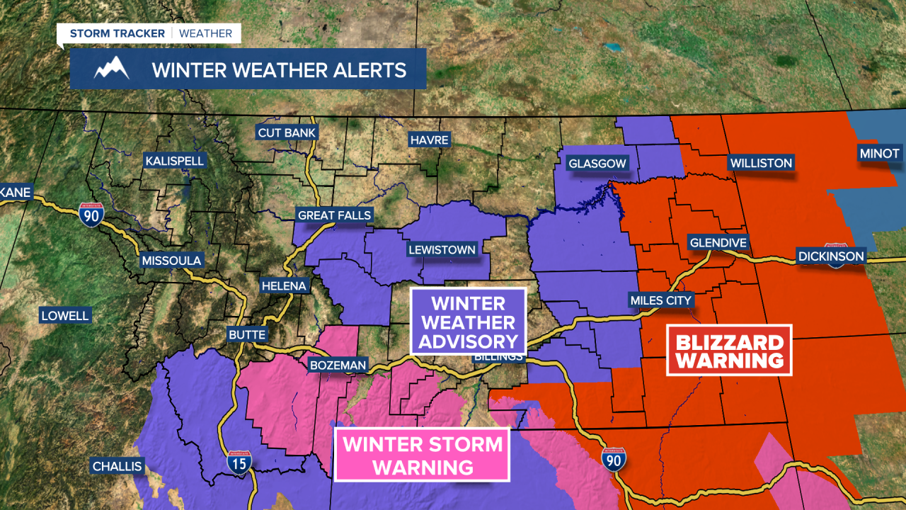
Discussion: A dynamic, spring storm begins to lift northeast into the Dakotas later this evening spreading rain throughout eastern Montana, even the chance for some stronger thunderstorms in far southeastern Montana. Rain quickly changes to heavy snow and near blizzard conditions at times for far eastern Montana. Mountain areas will also pick up moderate to heavy snow accumulations in central and southern Montana. Little to no impact is expected in lower elevations throughout central and southwestern Montana.
The state begins to clear out of precipitation and stronger winds as a upper-level ridge begins to build in by Sunday. This provides calmer and warmer weather for most locations. Temperatures will be flirting with 70 degrees in some locations, finally feeling like spring. A return to cooler and wetter weather is likely with another potential spring storm by the end of next week.

Friday: Overcast with showers in the afternoon and evening. Accumulating snow in the higher elevations. High temperatures in the upper 40s. Mostly cloudy overnight with temperatures falling into the low to mid 30s.
Saturday: Mostly cloudy. Scattered rain and snow showers possible. High temperatures in the upper 40s and low 50s. Overnight low temperatures in the upper 20s.

Sunday: Clearing out, with mostly sunny skies for the afternoon and evening. High temperatures in the upper 50s. Remaining mostly clear overnight as temperatures fall into the lower 30s.

Monday: Mostly sunny and mild. High temperatures in the mid to upper 60s. A tad breezy with a sustained SSW wind at 10-15 MPH gusting to 30 MPH at times. Overnight low temperatures in the upper 30s.
Tuesday: Increasing clouds. High temperatures in the upper 60s. A few showers possible during the late evening and overnight. Temperatures fall into the mid 30s.
Wednesday: Partly cloudy with scattered showers possible. High temperatures in the upper 50s. Overnight low temperatures in the lower 30s.
Thursday: Mostly cloudy. Showers possible. High temperatures in the mid 50s.
