


A cold front approaches the area throughout Monday with some peaks of sun ahead of the front. Overcast skies by lunch time and the front moves through between lunch and dinner time.
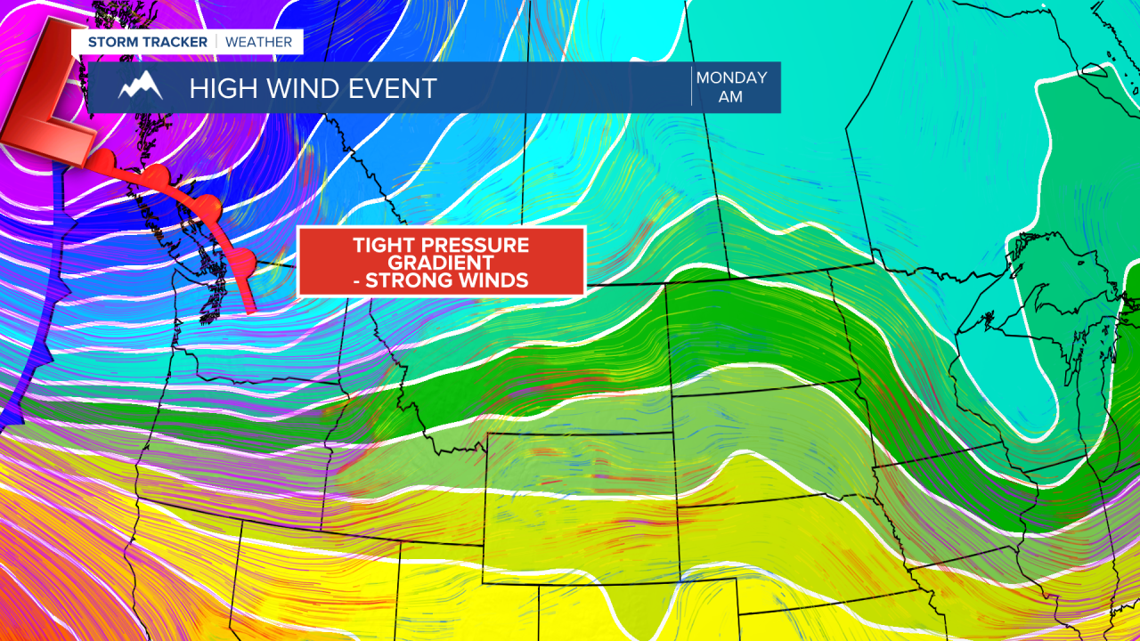
Winds ramp up quickly with gusts up to 65 MPH for the plains and as high as 85 MPH for the Rocky Mountain. There is even the chance of some scattered thunderstorms with the front.
The storms will stay non-severe but could pack heavy downpours and damaging wind gusts. A brief cooldown is in store in wake of the cold front on Tuesday. Although it will be short-lived, a warming trend is expected for the rest of the week with almost summer-like warmth by Friday as temperatures will run about 20-25 degrees above normal.
A cooler and potentially wetter pattern looks to settle in for next weekend and into the following week.


Sunday night: Partly to mostly cloudy skies. Overnight low temperatures in the low to mid 30s. Wind SW 5-10 MPH.

Monday: Mostly cloudy skies. Scattered showers and thunderstorms during the afternoon and evening. High temperatures in the upper 50s. Wind ramps up following a cold front passage during the afternoon and evening. Sustained winds of 25-35 MPH gusting to 60 MPH during the afternoon, evening and overnight. Higher wind speeds for the Rocky Mountain Front with gusts as high as 85 MPH. Overnight low temperatures in the upper 20s to around 30.

Tuesday: A few snow showers possible in the morning, followed by partly cloudy skies. Remaining windy during the entire day. Sustained winds of 25-35 MPH gusting to 55 MPH. High temperatures in the mid 40s. Remaining breezy overnight as temperatures fall into the low 30s.
Wednesday: Partly cloudy and breezy. Sustained winds of 15-20 MPH gusting to 30 MPH. High temperatures in the lower 50s. Decreasing clouds overnight with overnight low temperatures in the low to mid 20s.
Thursday: Mostly sunny. High temperatures in the mid 60s. Overnight low temperatures in the mid to upper 30s.
Friday: Mostly sunny and unseasonably mild. High temperatures in the upper 60s and low 70s. Overnight low temperatures in the upper 30s and low 40s.
Saturday: Partly cloudy. Scattered showers possible. High temperatures in the mid to upper 50s. Overnight low temperatures in the lower 30s.
Sunday: Rain and snow showers possible. High temperatures in the mid to upper 40s.
