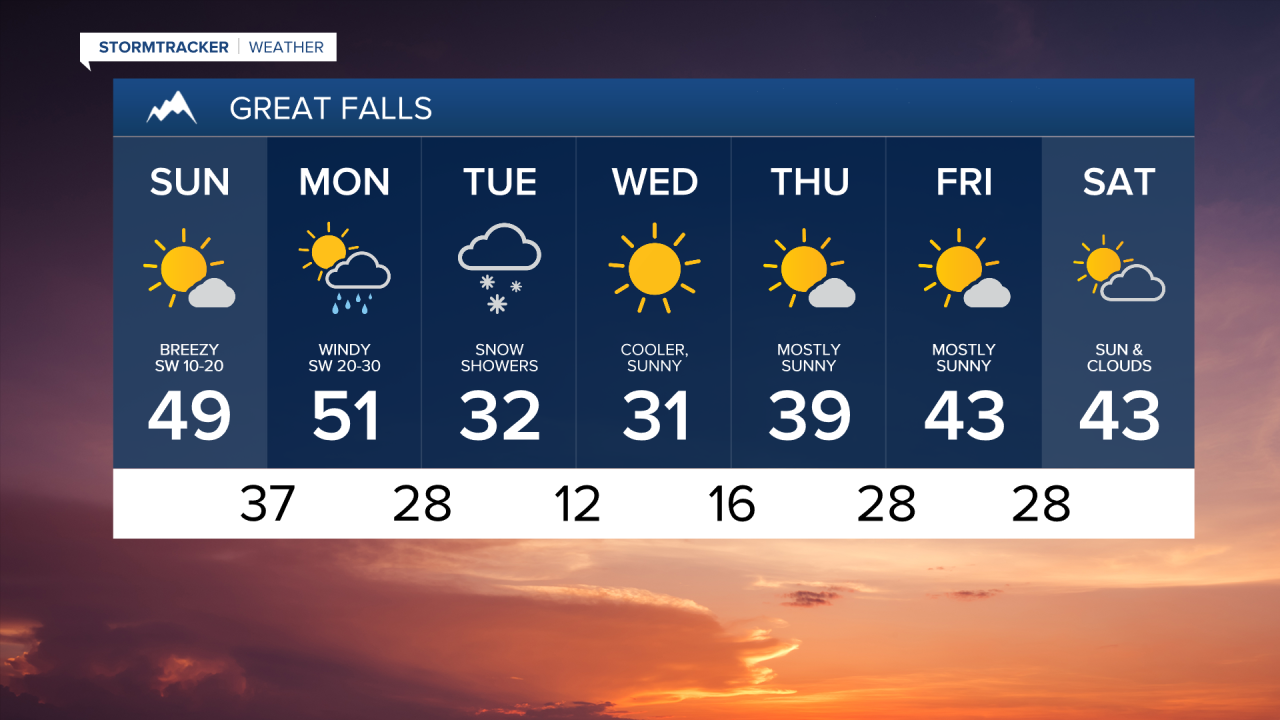
WEATHER DISCUSSION: Chinook winds will continue to keep temperatures 10-15 degrees above climatological normal. Strong crosswinds will continue for north-south oriented highways near the Rocky Mountain Front.
A low pressure system and an associated cold front move across the region on Monday. Temperatures fall into the 10s and 20s overnight with a very icy Tuesday morning commute expected. A light, accumulating snow impacts lower elevations and moderate to heavy snowfall in the mountains.
High pressure builds back in towards the end of the week as temperatures begin to warm back above climatological normal. A gusty wind persists throughout the week.

SATURDAY NIGHT: Mostly clear to partly cloudy skies. Temperatures falling into the upper 10s and lower 20s for the Helena Valley and the Hi-Line, mid to upper 20s for the Rocky Mountain Front and central Montana.
SUNDAY: Mostly sunny, mild and breezy. A sustained SW breeze at 10-25 MPH gusting to 60 MPH at times for the Rocky Mountain Front, 45 MPH for the rest of central and eastern Montana. Temperatures rising into the upper 30s and lower 40s for the Helena Valley and the Hi-Line, upper 40s and lower 50s for the Rocky Mountain Front and central Montana. Partly to mostly cloudy and breezy overnight as temperatures fall into the low to mid 20s in northeastern Montana, lower 30s for the Helena Valley and the Hi-Line, and mid to upper 30s for the Rocky Mountain Front and central Montana.
MONDAY: Increasing clouds and scattered rain and elevation snow showers. Remaining breezy with a sustained SW wind at 20-35 MPH gusting up to 70 MPH at times for the Rocky Mountain Front, up to 55 MPH for the rest of central Montana. High temperatures in the mid to upper 40s and lower 50s. Rain and snow showers developing overnight as temperatures fall into the low to mid 20s.
TUESDAY: Breezy with snow showers likely. A sustained north-northwesterly breeze sustained at 10-25 MPH gusting up to 40 MPH at times. Snow accumulating a coating to 3 inches in lower elevations, 4-10" at pass levels, 10-20"+ at higher peaks through Tuesday evening. High temperatures in the upper 20s and lower 30s. Snow tapering overnight as temperatures fall into the 0s and 10s.
WEDNESDAY: Sunny to mostly sunny. Chilly with highs in the low to mid 20s for the Hi-Line, upper 20s and lower 30s for the rest of central and eastern Montana. Increased cloud cover overnight as temperatures fall into the low to mid 10s.
THURSDAY: Sunny to mostly sunny. Highs in the mid 20s for northeastern Montana, low to mid 30s for the Hi-Line and the Helena Valley, mid to upper 30s for the Rocky Mountain Front and central Montana.