


We're welcoming summer later today, as the summer solstice is at 8:42 p.m.! It was an electrifying night in Big Sky Country, with numerous showers and thunderstorms producing cloud-to-ground lightning.
Scattered showers and thunderstorms will move from southwest to northeast across the area throughout the day. A few of the storms could go severe, primarily bringing heavy rainfall and strong winds. There is a Level 2 (Slight) to Level 3 (Moderate) risk for eastern Montana, where severe thunderstorms could produce damaging winds (58+ mph), very large hail (2"+ diameter), and isolated tornadoes.

A cloudy and cool Friday ahead as temperatures range from the 50s near the Rocky Mountain Front to the mid 70s in northeastern Montana.
It will be breezy, with sustained winds between 10 and 20 mph and gusts up to 40 mph.

The showers and thunderstorms continue into tonight. The intensity of the precipitation will increase in Glacier tonight into Saturday. Snow levels will also drop to around 5,000 feet with periods of snow.
A good chunk of the day is going to be dry on Saturday across the plains, we may even get some sunshine in. Rain will continue for Glacier county and snow throughout most of the day in Glacier National Park.
The wind is going to get fairly strong on Saturday, especially along the Rocky Mountain Front and the Hi-Line from Browning to Chester and down to Conrad.
A High Wind Warning is in effect, with gusts up to 60 mph and wind speeds between 20 and 40 mph. Elsewhere, winds will range from 10 to 25 mph, gusting up to 40 mph. Temperatures will range from the 40s along the Rocky Mountain Front to the 70s in eastern Montana.


Rain will begin to redevelop Sunday morning and continue throughout the day, with snow levels down around 5,000 to 5,500 feet. It will be another cool, cloudy day with highs in the 40s and 50s.

This system will bring beneficial rainfall to most of Montana. As per usual, rain totals will vary, but most of north-central Montana should receive between 0.5" and 1.5" of precipitation, with some areas in Glacier National Park and Glacier County receiving over 2".

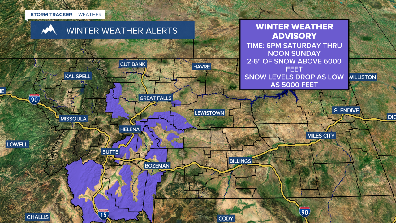
A Winter Storm Warning is in effect for Glacier National Park is active from 9 a.m. Saturday through noon Sunday. Heavy wet snow could bring down some trees and powerlines.
It is likely Going-to-the-Sun road will temporarily close this weekend due to heavy snow. Up to 6 inches of snow is possible below 6000 feet and 12-18"+ of snow above 6000 feet. It will also be very breezy with gusts up to 45 mph leading to blowing and drifting snow. If you are going to be recreating outdoors this weekend in Glacier National Park or the Bob Marshall Wilderness, be prepared for cold, wet, and raw conditions. In the other mountains in central and north-central Montana, a coating to a few inches of snow is possible.


A quick rebound is expected for next week as temperatures warm into the 60s and 70s on Monday and 70s and 80s for the rest of the week. However, there will still be some isolated showers and thunderstorms around.


