WEATHER DISCUSSION: A weak disturbance will bring a light, accumulating snow for higher elevations overnight Sunday into Monday morning. A coating to 4 inches is expected over mountain passes throughout central and southwestern Montana.
Persistent high winds will impact the Rocky Mountain front and, at times, the plains of central and eastern Montana. Dangerous crosswinds anticipated for north-south oriented roadways. Sporadic gusts up to 80 MPH possible for the Rocky Mountain Front, up to 60 MPH for the plains. The gustiest time period will be Monday night through Tuesday afternoon and Tuesday evening through Wednesday.
A cold front traverses the region late Tuesday night into Wednesday morning accompanied by a brief period of snow showers and strong wind gusts region-wide. Slightly cooler temperatures anticipated for Wednesday and Thursday, however still above seasonable average in most cases.
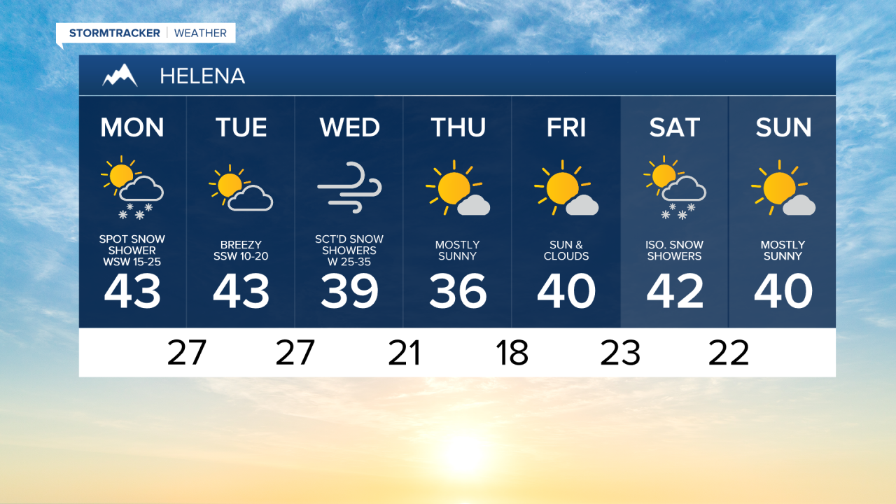
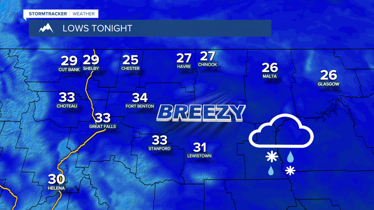
SUNDAY NIGHT: Scattered rain and snow showers around. Accumulations confined to elevations above 5000 feet. Breezy with a sustained SW wind at 15-25 MPH gusting up to 35 MPH at times. Overnight lows in the mid to upper 20s for the Hi-Line, low to mid 30s for central Montana.
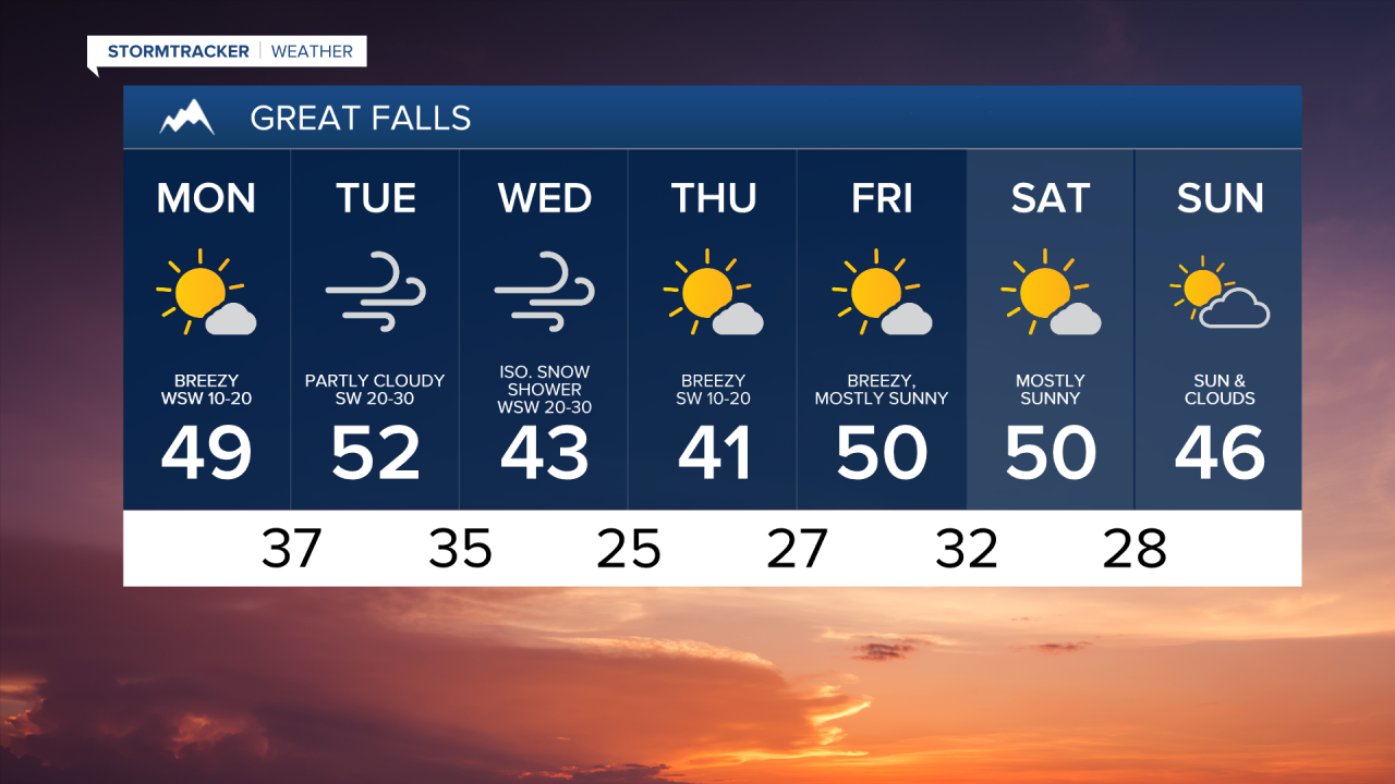
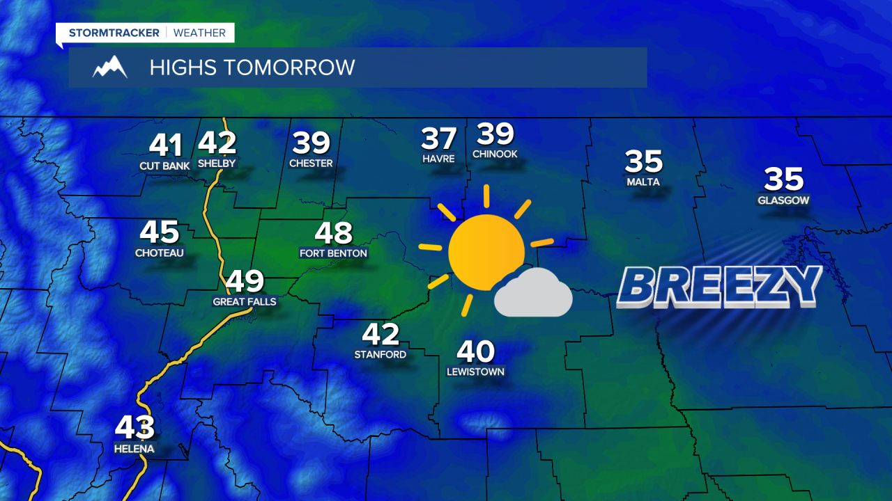
MONDAY: Decreasing clouds. Breezy with a sustained SW wind at 15-25 MPH gusting up to 40 MPH at times. High temperatures in the mid to upper 30s for the Hi-Line, mid to upper 40s for the Rocky Mountain Front and central Montana. Increasing wind and cloud cover overnight as temperatures fall into the 20s. Sustained wind 30-45 MPH, gusting to 65 MPH for the Rocky Mountain Front. A sustained wind of 15-30 MPH, gusting to 50 MPH for the plains.
TUESDAY: Partly cloudy and breezy. A sustained breeze at 20-35 MPH, gusting to 55 MPH for the Rocky Mountain Front. A sustained breeze of 10-20 MPH, gusting to 35 MPH for the plains. High temperatures in the mid 40s to low 50s for central Montana, upper 30s and lower 40s for eastern Montana. Mostly cloudy and breezy overnight as temperatures fall into the upper 20s and low to mid 30s. Scattered snow showers developing in the mountains.
WEDNESDAY: Scattered snow showers, windy and mostly cloudy. High temperatures in the upper 30s and low to mid 40s. Wind gusts up to 70 MPH for the Rocky Mountain Front, up to 55 MPH for the plains. Remaining mostly cloudy as temperatures fall into the upper 10s and low to mid 20s.
THURSDAY: Sunny to mostly sunny. Cooler with highs in the mid to upper 30s for the Hi-Line, low to mid 40s for central Montana. Partly cloudy overnight with temperatures falling into the upper 10s and lower 20s for the Hi-Line, mid to upper 20s for the Rocky Mountain Front and central Montana.
FRIDAY: Mostly sunny and breezy. High temperatures in the upper 30s and lower 40s for the Hi-Line, upper 40s and lower 50s for the Rocky Mountain Front and central Montana. Partly cloudy overnight as temperatures fall into the low to mid 20s for the Hi-Line, upper 20s and lower 30s for the Rocky Mountain Front and central Montana.
TRENDING
- Video of "explosion" above Montana
- Coming Up: Events Calendar
- Recent obituaries on KRTV
- A visit to "ghost town" St. Marie
FOLLOW KRTV