**A strong geomagnetic storm watch has been issued for Wednesday night, and a moderate geomagnetic storm watch has been issued for Thursday night. This means that the aurora borealis may be visible during these two nights in the northern United States. As of right now, Wednesday night features the best chance to see the northern lights in Montana, followed by Thursday night. For tonight, there is a very slim chance that we will see the northern lights in Montana.**

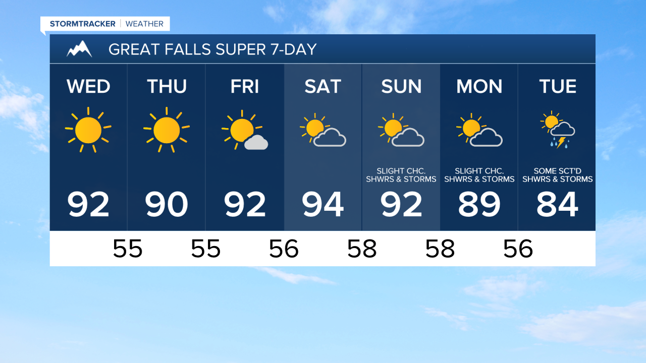
Most locations are going to be dry tonight and tomorrow, but there will be a few showers and thunderstorms around in northeastern Montana, including in Valley County, as a weak disturbance passes through our area. We are also going to have mostly to mainly clear skies tonight and mainly sunny skies tomorrow.
Lows tonight are going to be in the mid to upper 50s and low 60s in most locations. For tomorrow, highs are going to be in the mid to upper 80s and low to mid 90s, so it will be a little bit cooler than it was today. There is also going to be a little bit of a breeze around tomorrow as sustained wind speeds are going to be between 5 and 20 mph, and wind gusts up to 30 mph are going to be possible at times. The wind tomorrow is also going to be coming out of the north.
On Thursday, we are going to have lots of sunshine and dry conditions. We are then going to have partly cloudy to mostly sunny skies and mainly dry conditions on Friday. It is also going to continue to be hot on these two days as highs are going to be in the mid to upper 80s and low to mid 90s in most locations. There is also going to be a little bit of a breeze around on these two days as sustained wind speeds are going to be between 5 and 20 mph, and this wind is going to be coming out of the northeast.
For this weekend, we are going to have partly cloudy skies with a slight chance of PM showers and thunderstorms on Saturday, and partly cloudy skies with some isolated showers and thunderstorms around on Sunday, generally during the PM hours, as some monsoonal moisture attempts to work its way into our area. It is also going to continue to be hot this weekend as highs are going to be in the upper 80s and low to mid 90s in most locations.
On Monday, we are going to have partly cloudy skies with some isolated showers and thunderstorms around, generally during the evening, as a disturbance begins to approach our area. There are then going to be some scattered showers and thunderstorms around on Tuesday as this disturbance passes through our area. The temperatures are also going to cool down a little bit early next week as highs on Monday are going to be in the mid to upper 80s and low 90s, and highs on Tuesday are going to be in the 80s.