


It was an extremely windy day today, and in some locations, the wind was stronger today than it was this past Sunday. Peak wind gusts were between 50 and 80 mph in most locations.
The strongest wind gust was 104 mph, which was recorded on top of Judith Peak in Fergus County.

This strong wind caused numerous power outages and some property damage. It also blew over many semis across the state leading to several road closures.

The worst of the wind is now done with, and the wind will continue to diminish this evening/tonight.
For most, there is just going to be a little breeze around tonight, but it will continue to be gusty along the Divide/Rocky Mountain Front and in/around the higher terrain in central Montana as gusts over 50 mph are possible.
On Friday, there will just be a little breeze around (5-15 mph) in most spots, but it will continue to be breezy along the Divide (10-20 mph).
Here is the detailed forecast:
Our attention now shifts from the wind to the impending snowstorm. There were scattered rain and snow showers around throughout the day today. Tonight, snow is likely in north-central Montana, and snow, potentially mixing in with some rain, is likely around the Helena area, with the precipitation becoming more widespread during the second half of the night.
Around Helena, snow/rain is likely tomorrow through Saturday, with the precipitation switching back and forth between snow and rain in some of the lower elevations, including in the Helena Valley and along Highway 287 south/east of Helena. In north-central Montana, widespread light to moderate snow is expected tomorrow through Saturday, with the more widespread snow falling on Saturday. Some of the snow that falls may be heavy at times, especially on Saturday. The snow will gradually taper off later Saturday and Saturday night.
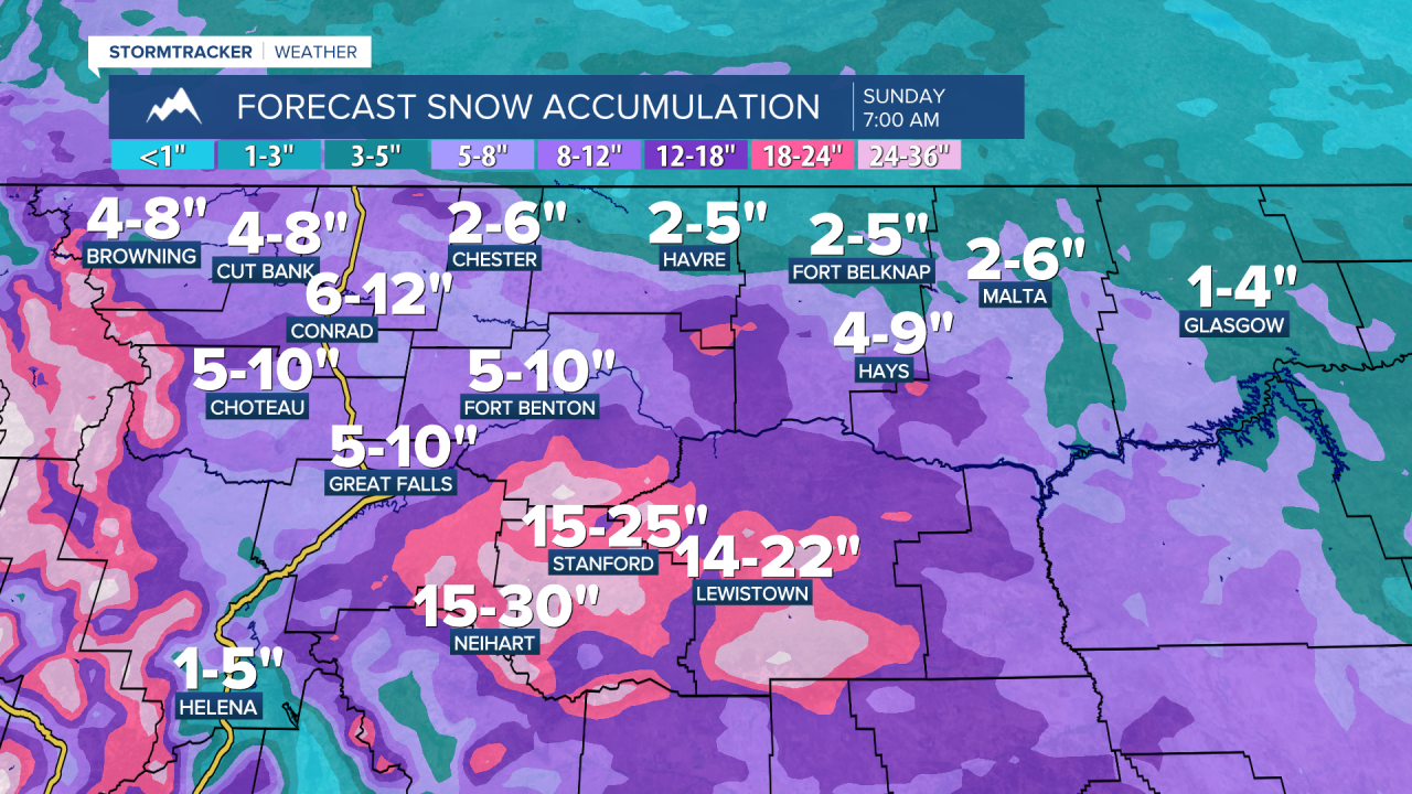
A WINTER STORM WARNING is in effect for western and southern portions of north-central Montana and the Helena area until 6pm Saturday and a WINTER WEATHER ADVISORY is in effect for portions of north-central Montana until 6pm Saturday.

Through Sunday morning, the highest snow amounts will be in the mountains as 1-3 FEET of snow is expected. There will also be significant snow accumulation in Fergus County, Judith Basin County, and eastern portions of Cascade County, as 10-25” of snow is expected. Travel will be extremely difficult along Highway 87/200 from Belt/Armington Junction through the Lewistown area the next couple of days. Along the Hi-Line east of I-15, a general 1-6” of snow is expected. Elsewhere in north-central Montana, 4-12” of snow is expected, with isolated higher amounts.

Snow amounts are harder to forecast for the Helena Valley and the Townsend/Toston areas as it will come down to how much precipitation falls as rain versus snow. Right now, <2” of snow is expected along Highway 287 east/south of Helena, and 1-5” of snow is expected in the Helena Valley. If more precipitation falls as snow than rain, then the snow amounts will be higher than forecasted. The Lincoln area will also be hit hard with this storm as 8-16” of snow is expected.
Travel will be difficult to impossible in the higher terrain in western Montana through Saturday night due to heavy snow and reduced visibility. Many mountain passes will be impacted. Travel will also be difficult at times in the lower elevations through Saturday night. Use extreme caution when traveling.
Highs tomorrow will be in the upper 20s and low to mid 30s in north-central Montana and the mid to upper 30s and low to mid 40s around Helena. It is then going to be cold on Saturday as highs are only going to be in the 20s and low to mid 30s. It will also be blustery on Saturday as sustained wind speeds are going to be between 10 and 25 mph, so blowing snow will be an issue.
Sunday will be mostly cloudy, mostly dry, and chilly as highs are going to be in the 20s and low to mid 30s in most locations. Some more scattered rain and snow showers are then possible on Monday, generally in central Montana, as another disturbance impacts the state. It is also going to be warmer on Monday as highs are going to be in the 40s and low 50s in most locations (30s in northeastern Montana). Gusty winds will also return on Monday as sustained wind speeds are going to be between 10 and 30 mph.

A strong upper-level ridge will bring significantly warmer temperatures to the state for the rest of next week as highs are going to be in the mid to upper 50s and low to mid 60s on Tuesday and the mid to upper 60s and low to mid 70s Wednesday and Thursday. It is also going to be windy on these three days as sustained wind speeds are going to be between 15 and 35 mph, and wind gusts over 50 mph are possible. Partly to mostly cloudy skies and dry conditions are also expected on these three days.


