


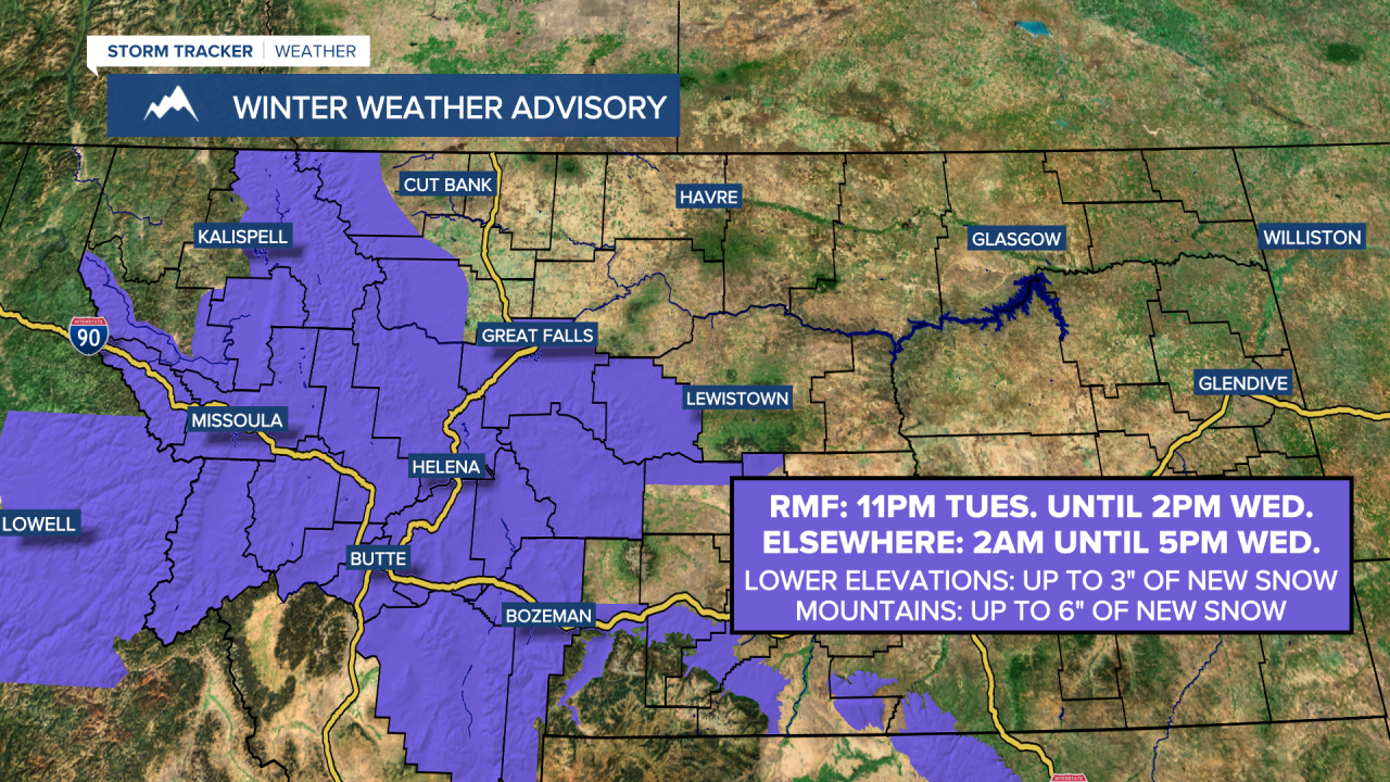
A Winter Weather Advisory is in effect for the Rocky Mountain Front from 11pm Tuesday until 2pm Wednesday. A Winter Weather Advisory is also in effect for Broadwater County, Cascade County, Jefferson County, Judith Basin County, most of Lewis and Clark County, and Meagher County from 2am until 5pm Wednesday. In the lower elevations, up to 3 inches of snow accumulation is possible. In the mountains, up to 6 inches of snow accumulation is possible.
Snow is likely tonight and tomorrow, especially between midnight tonight and noon tomorrow, as a disturbance passes through our area. A coating to 3 inches of new snow accumulation is expected in the lower elevations, and 2 to 6 inches of new snow accumulation is expected in the higher elevations. Slippery road conditions are also expected tonight and tomorrow, and the Wednesday morning commute is likely going to be very slick, so please be careful when driving and give yourself some extra time to get to where you need to go.


It is also going to be chilly tonight and tomorrow as lows tonight are going to be in the mid to upper teens and low to mid 20s, and highs tomorrow are going to be in the mid to upper 20s and low 30s. There is also going to be a little bit of a breeze around tomorrow as sustained wind speeds are going to be between 5 and 20 mph. We are also going to have overcast skies tonight and tomorrow morning, then decreasing clouds tomorrow afternoon and evening.
For Thursday, we are going to have partly to mostly cloudy skies with a few scattered rain and snow showers around, generally during the afternoon/evening and especially in locations east of I-15, as another disturbance passes through our area. It is also going to be warmer on Thursday than it is going to be tomorrow as highs are going to be in the mid to upper 30s and low to mid 40s. Gusty to strong winds are also expected on Thursday as sustained wind speeds are going to be between 15 and 35 mph, and wind gusts over 50 mph are going to be possible at times.
On Friday, we are going to have partly cloudy skies and mostly dry conditions. We are then going to have partly to mostly cloudy skies on Saturday with some isolated rain and snow showers around, generally during the afternoon/evening and especially in locations west of I-15. It is also going to be breezy on Friday as sustained wind speeds are going to be between 10 and 20 mph, and it is going to be windy on Saturday as sustained wind speeds are going to be between 15 and 30 mph. Mild temperatures are also expected on these two days as highs are going to be in the 40s and low to mid 50s.
Snow is then likely on Sunday as a storm system begins to pass through our area. There are then going to be some scattered snow showers around on Monday, especially during the morning, as this storm system leaves our area. This storm system is also going to bring some much colder air to our area as the temperatures are going to be falling throughout the day on Sunday from the 30s to the teens, and highs on Monday are only going to be in the single digits and teens. It is also going to be breezy on Sunday and a bit breezy on Monday as sustained wind speeds are going to be between 10 and 25 mph.
We are then going to have partly to mostly cloudy skies, dry conditions, and cold temperatures on Tuesday as highs are only going to be in the teens.
TRENDING ARTICLES
- 'Suspicious death' reported in Cascade County
- Benefis update on impact of vaccine mandate
- Murder-suicide reported at Great Falls hotel
- Blockade ends at Sweet Grass/Coutts border
- Work continues on new apartments in Great Falls


