A DENSE FOG ADVISORY is in effect for a lot of eastern Montana and portions of the Hi-Line (Hill County and eastward) until 9am/11am Wednesday. Visibility, at times, is going to be at or below a quarter mile.

We are going to have partly cloudy to mostly clear skies tonight. There are also going to be some areas of fog around tonight along the Hi-Line (Hill County and eastward) and in eastern Montana. Some of this fog may be dense, with visibility less than a quarter mile.
It is also going to be cold tonight along the central and eastern half of the Hi-Line as lows are going to be in the single digits above/below zero. Elsewhere, it is going to be chilly tonight as lows are going to be in the teens and 20s. We are also going to have gusty winds around tonight along the Rocky Mountain Front as wind gusts up to 50 mph are going to be possible at times, and it is going to be breezy tonight in some locations east of the Rocky Mountain Front as wind gusts up to 40 mph are going to be possible at times.
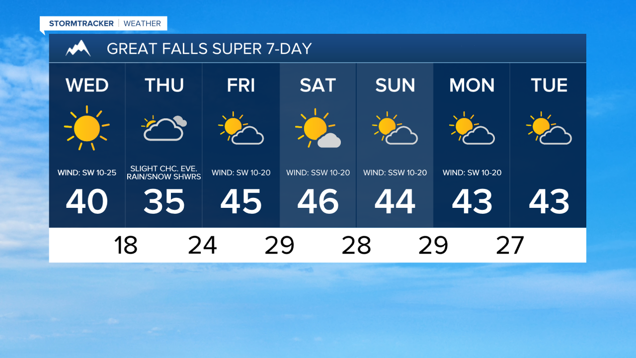
For tomorrow, it is going to be another beautiful day as once again we are going to have lots of sunshine. There are also going to be some areas of fog around tomorrow morning along the Hi-Line (Hill County and eastward) and in eastern Montana, and some of this fog will be dense.
We are also going to have a wide range of temperatures tomorrow as highs are going to range from the mid teens to the low 40s, with most locations topping out in the 20s and 30s. Also, the coldest temperatures tomorrow will be in northeastern Montana. It is also going to be breezy tomorrow in portions of central and north-central Montana as sustained wind speeds are going to be between 10 and 25 mph, and the strongest wind tomorrow is going to be during the morning.
We are then going to have increasing clouds on Thursday as a disturbance begins to approach our area. Not much precipitation is expected with this disturbance, but there are going to be a few scattered rain and snow showers around from Thursday afternoon through Friday morning as this disturbance passes through our area. We are also going to have overcast skies Thursday night and mostly to partly cloudy skies on Friday.
The temperatures are also going to warm up some between Thursday and Friday as highs on Thursday are going to be in the 20s and 30s in most locations (teens along portions of the Hi-Line), and highs on Friday are going to be in the 30s and low to mid 40s in most locations (teens in northeastern Montana). It is also going to be breezy in some areas on Friday as sustained wind speeds are going to be between 10 and 25 mph, and wind gusts up to 40 mph are going to be possible at times.
For this weekend, we are going to have mostly sunny skies and dry conditions on Saturday and partly to mostly cloudy skies and mainly dry conditions on Sunday as high pressure is going to be in control of our weather. It is also going to be breezy in some areas this weekend as sustained wind speeds are going to be between 10 and 25 mph, and wind gusts up to 40 mph are going to be possible at times. We are also going to have pleasant temperatures this weekend as highs are going to be in the 30s and low to mid 40s in most locations (20s in northeastern Montana).
On Monday, we are going to have partly cloudy skies and dry conditions. We are then going to have partly to mostly cloudy skies and mostly dry conditions on Tuesday. It is also going to be breezy on Monday as sustained wind speeds are going to be between 10 and 25 mph. We are also going to continue to have pleasant temperatures on these two days as highs are going to be in the 30s and low to mid 40s in most locations.