


A WINTER WEATHER ADVISORY is in effect for portions of central and north-central Montana until 5am/11pm Monday. 1 to 6 inches of total snow accumulation is expected.
A WINTER WEATHER ADVISORY is in effect for Phillips County and Valley County from 11am Monday until 5pm Tuesday. 1 to 3 inches of snow accumulation is expected.

There are going to be scattered areas of snow tonight, especially before midnight and generally in central Montana and in central/western portions of north-central Montana. There are then going to be areas of light to moderate snow around tomorrow, especially during the second half of the day, as another disturbance passes through our area.
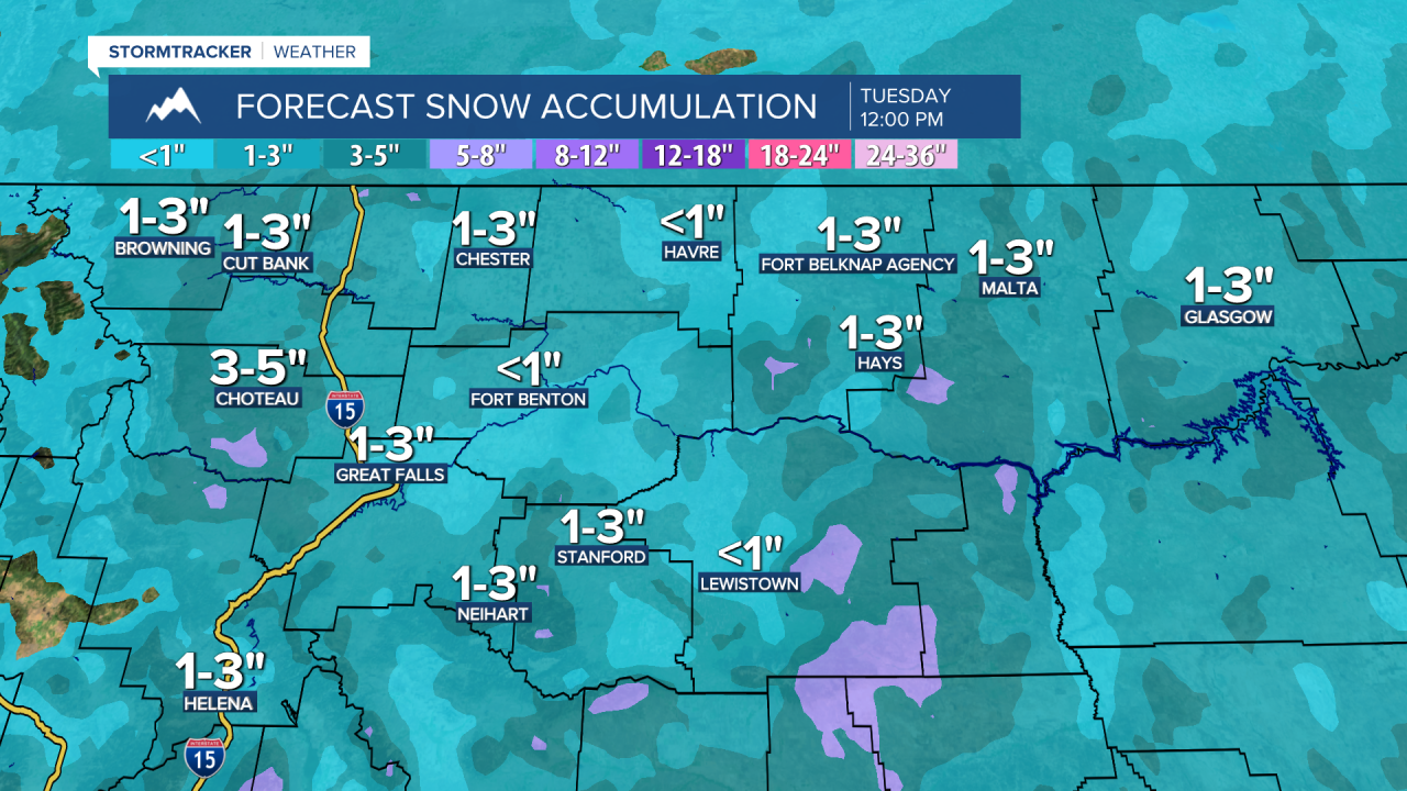
Between this evening and Tuesday morning, a coating to 4 inches of new snow accumulation is possible, with up to 7 inches of new snow accumulation possible in the mountains. This snow is also going to create slippery road conditions, so please be careful when traveling and give yourself some extra time to get to where you need to go.
It is also going to be breezy tonight and tomorrow (generally in locations east of I-15) as sustained wind speeds are going to be between 10 and 25 mph, and wind gusts up to 40 mph are going to be possible at times. Cold temperatures are also expected tonight and tomorrow as lows tonight are going to be in the single digits and teens, and highs tomorrow are going to be in the 20s and upper teens.
On Tuesday, we are going to have mostly to partly cloudy skies with some isolated snow showers around, especially during the afternoon/evening and especially in the mountains. It is also going to be chilly on Tuesday as highs are going to be in the mid to upper 20s and low to mid 30s.
There are then going to be some more isolated snow showers around on Wednesday and Thursday as a disturbance passes by our area to the south. We are also going to have mostly to partly cloudy skies on these two days. It is also going to continue to be chilly on these two days as highs are going to be in the 20s and low 30s in most locations.
Warmer temperatures are then expected for Friday and this weekend as highs on Friday are going to be in the low to mid 30s, and highs this weekend are going to be in the mid to upper 30s and low 40s. The one exception will be along the central and eastern half of the Hi-Line where it is going to continue to be chilly on these three days as highs are going to be in the mid to upper 20s and low 30s. It is also going to be breezy this weekend as sustained wind speeds are going to be between 10 and 20 mph, and this wind is going to be coming out of the southwest.
On Friday, we are going to have mostly cloudy skies with some scattered snow showers around during the afternoon and evening as a storm system begins to approach our area. There are then going to be scattered snow showers around Friday night, and some scattered snow and rain showers around on Saturday, especially during the morning, as this storm system passes through our area. We are also going to have mostly cloudy skies on Saturday.
There are then going to be some isolated snow and rain showers around on Sunday, generally during the afternoon and evening, as the next storm system begins to approach our area. We are also going to have partly to mostly cloudy skies on Sunday.


