A WINTER WEATHER ADVISORY is in effect for the high plains next to the Rocky Mountain Front and for portions of central Montana until 12am/6am Thursday or 12am Friday.

A WINTER STORM WARNING is in effect for the Rocky Mountain Front until 12am Thursday and for portions of central and southwestern Montana until 12am Friday.

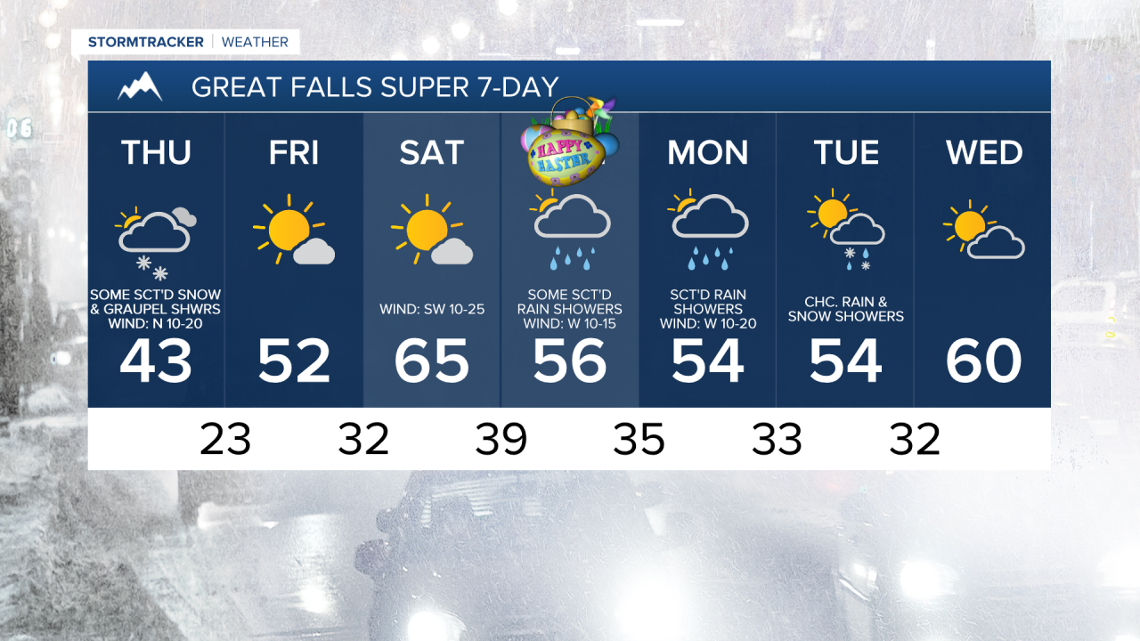
It was a wet, chilly, and breezy day today as a spring storm began to impact our area. For tonight, precipitation will continue to move southward, which also means that precipitation will gradually taper off from north to south as the night goes on. Most of the precipitation that falls tonight will be in the form of snow, but rain is possible at times in some locations. By midnight, most of the precipitation will be out of north-central Montana, but the precipitation will continue in the central part of the state, including around Helena and Lewistown, through tomorrow morning.
For tomorrow, we are going to have mostly to partly cloudy skies with scattered snow/graupel showers around as this storm system begins to pull away from our area. A few rain showers are also possible tomorrow.
In the lower elevations in central Montana, up to 4” of new snow accumulation is possible through tomorrow night, and in the mountains in central Montana, up to 8” of new snow accumulation is possible. In north-central Montana, <1” of new snow accumulation is expected in most spots through tomorrow night. The bulk of this snow accumulation will occur tonight into tomorrow morning. Due to this snow, roads will be slick in some areas tonight and tomorrow morning, so please use caution when driving and give yourself some extra time to get to where you need to go.

It is also going to be cool tonight as lows are going to be in the 20s and low 30s, and it is going to be chilly tomorrow as highs are going to range from the mid 30s to the low 50s. There is also going to be a bit of a breeze around tonight in central Montana as sustained wind speeds are going to be between 10 and 20 mph. It is then going to be breezy again tomorrow as sustained wind speeds are going to be between 10 and 25 mph, and gusts up to 40 mph are possible.
Sunnier, warmer, and drier weather is then expected on Friday and Saturday. On Friday we are going to have partly to mostly sunny skies with a few snow showers around in eastern Montana. We are then going to have lots of sunshine Saturday morning and increasing clouds Saturday afternoon/evening as the next disturbance begins to approach our area.
The temperatures are also going to warm up a lot over these two days as highs are going to be in the mid to upper 40s and low to mid 50s on Friday and the 60s and upper 50s on Saturday. We will also get a break from the wind on Friday, but breezy conditions will return on Saturday as sustained wind speeds are going to be between 10 and 25 mph.
On Easter Sunday, we are going to have partly to mostly cloudy skies with some scattered rain and mountain snow showers around, especially in the higher elevations, as a disturbance begins to impact our area. It is also going to be cooler and a bit breezy on Easter as highs are going to be in the 50s, and sustained wind speeds are going to be between 10 and 20 mph.
An upper-level trough will then provide us with unsettled weather for the beginning of next week. Around Helena, rain/snow is likely on Monday and there are going to be a few scattered snow/rain showers around on Tuesday. In north-central Montana, there are going to be scattered rain and mountain snow showers around on Monday, especially during the PM hours, and there are going to be a few scattered rain/snow showers around on Tuesday, especially during the morning. We are also going to have mostly cloudy skies on Monday and partly cloudy skies on Tuesday. It is also going to be cool on these two days as highs are going to be in the mid to upper 40s and low to mid 50s. There is also going to be a bit of a breeze around on Monday as sustained wind speeds are going to be between 10 and 20 mph.