A DENSE FOG ADIVSORY is in effect for portions of the Hi-Line until 8am/11am Thursday. Visibility, at times, is going to be at or below a quarter mile.

A HIGH WIND WATCH is in effect for Glacier County, northern Lewis and Clark County, western/central Pondera County, western/central Teton County, and western Toole County from 11am Saturday until 5am Sunday. Sustained wind speeds are going to be between 30 and 40 mph, and wind gusts up to 60 mph are going to be possible at times.

We are going to have increasing clouds tonight with some areas of dense fog around along portions of the Hi-Line. We are also going to have gusty winds around tonight along the Rocky Mountain Front as wind gusts over 40 mph are going to be possible at times. There is also going to be a bit of a breeze around tonight in some locations east of the Rocky Mountain Front as sustained wind speeds are going to be between 5 and 20 mph. It is also going to be chilly/cold tonight as lows are going to range from the single digits to the low 30s, with the coldest temperatures in northeastern Montana.
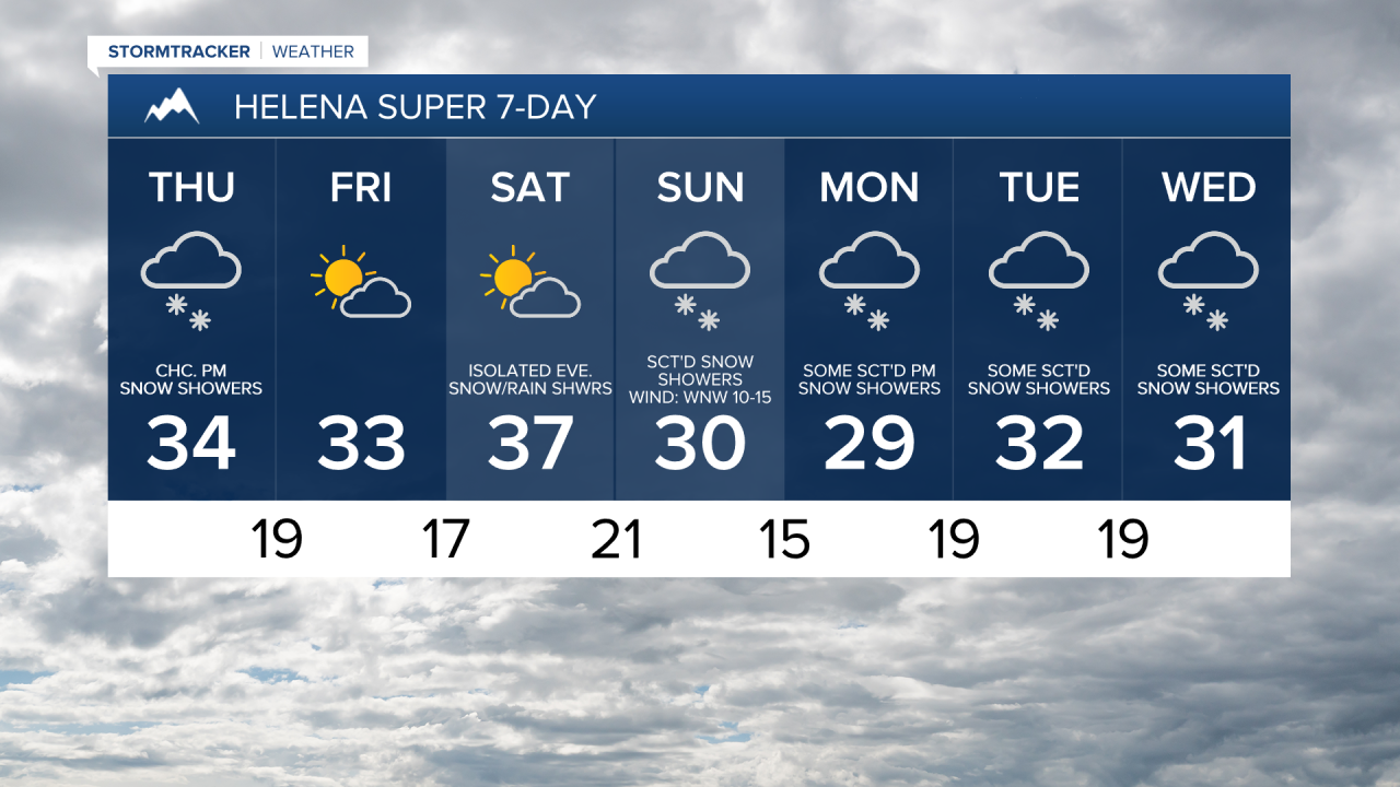
For tomorrow, we are going to have partly to mostly cloudy skies with a few scattered PM snow and rain showers around, generally in locations between Helena and Great Falls and in locations between the Continental Divide and I-15 in north-central Montana. In locations that do see some snow tomorrow, light snow accumulations of a coating to an inch or two are possible.

We are also going to have seasonable temperatures tomorrow as highs are going to be in the 20s, 30s, and low 40s. It is also going to be breezy in some areas tomorrow (especially east of I-15) as sustained wind speeds are going to be between 10 and 25 mph, and wind gusts up to 40 mph are going to be possible at times.
Partly cloudy skies and dry conditions are then expected on Friday as high pressure is going to be in control of our weather. It is also going to be breezy on Friday as sustained wind speeds are going to be between 10 and 25 mph. Seasonable temperatures are also expected on Friday as highs are going to range from the low 20s to the low 40s.
We are then going to have partly cloudy skies on Saturday with some isolated rain and snow showers around during the evening as a storm system begins to approach our area. There are then going to be scattered areas of snow around Saturday night and Sunday (especially Sunday morning) as this storm system passes through our area. A little bit of rain and freezing rain is also possible Saturday night with the initial onset of precipitation. Also, as of right now, a coating to 3 inches of snow accumulation is expected in the lower elevations, with higher amounts possible in some the mountains. We are also going to have decreasing clouds on Sunday.
We are also going to have gusty to strong winds around this weekend, with the strongest wind occurring between Saturday afternoon and Sunday morning. When the wind is at its strongest, sustained wind speeds are going to be between 20 and 40 mph, and wind gusts up to 60 mph are going to be possible at times. When the wind is not at its strongest, sustained wind speeds are going to be between 10 and 30 mph, and wind gusts over 40 mph are going to be possible at times. Also, the wind is going to be coming out of the southwest on Saturday and the west-northwest on Sunday. The temperatures are also going to cool down some between Saturday and Sunday as highs on Saturday are going to be in the 30s and low to mid 40s, and highs on Sunday are going to be in the mid to upper 20s and low to mid 30s.
There are then going to be some scattered snow showers around from Monday afternoon through Tuesday morning as another disturbance passes through our area. A little bit of rain and freezing rain is also possible on these two days. We are also going to have increasing clouds on Monday and decreasing clouds on Tuesday. It is also going to be chilly and breezy on these two days as highs are going to be in the 20s and 30s, and sustained wind speeds are going to be between 10 and 25 mph.
We are then going to have a chance to see some more scattered rain and snow showers on Wednesday as another disturbance passes through our area. It is also going to be chilly on Wednesday as highs are going to be in the mid to upper 20s and low to mid 30s.