


TODAY: We are looking forward to another dry day as we will stay mostly sunny heading into the middle of the week. High temperatures will once again be in the lower to upper 90s. The wind will remain light and variable.
TONIGHT: We will remain mostly clear heading into the night with a few passing clouds and will stay dry. Temps will be in the 50s for Western Montana and the 60s for Eastern Montana. The wind will be light and variable.
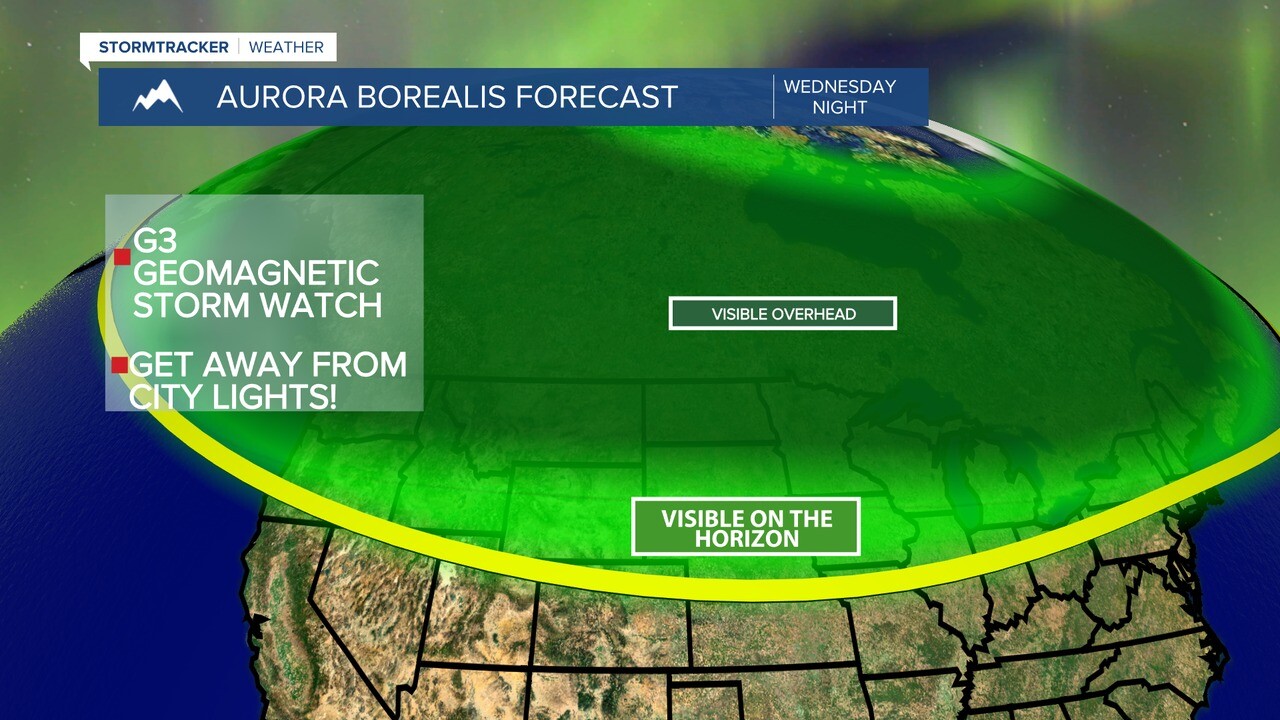
AURORA ALERT! The NOAA Space Weather Prediction Center has issued a G3 geomagnetic storm watch for Wednesday night, and a G2 geomagnetic storm watch for Thursday night. This means that the aurora borealis may be visible in portions of Montana over the next few nights. Wednesday night is when Montanans have the best chance to see the northern lights, followed by Thursday night.
Cloud cover can inhibit the viewing of the aurora borealis, but luckily for Montana, mostly to mainly clear skies are in the forecast for Wednesday night. If anything, the haze will probably interfere with aurora borealis viewing more than the clouds will. Partly cloudy to mostly clear skies are then expected Thursday night.
Remember the aurora borealis is hard to predict, and the geomagnetic storms may end up being stronger or weaker than what is currently predicted. The timing of the impact of the fast moving charged particles from the sun may also change, which could impact when the best chance to view the aurora borealis is. Point being - there is no guarantee that we will see the aurora borealis, but right now we do have a good chance to see it. Fingers crossed! In order to get the best viewing, make sure you are as far away from city lights as possible.
Two good resources for knowing when the Aurora Borealis might be visible in our area are the Space Weather Prediction Center and Soft Serve News. Jim Thomas, the operator of Soft Serve News, posts frequent updates to let people know how likely it is that the Northern Lights may be visible.
If you happen to take any pictures of the aurora borealis, feel free to send them to weather@krtv.com, or upload them by clicking here.
THURSDAY: Dry and hot conditions continue as we head into tomorrow. Temperatures will look to top out in the low to mid 90s. We will be under mostly sunny skies. The wind will once again be light and variable.
FRIDAY: Partly cloudy skies are expected as we warp up the work week as we will stay mostly dry. Highs will once again reach into the lower to upper 90s. The wind will be out of the Northeast around 5-15 mph.
SATURDAY & SUNDAY: The weekend is also looking to be hot once again with high temperatures ranging from the lower to upper 90s for both Saturday and Sunday. We will see partly cloudy skies on both days of the weekend. We will stay mostly dry on Saturday, but on Sunday we could see pop-up showers and thunderstorms heading into the afternoon. The wind will be light around 5-10 mph for our weekend outlook.
MONDAY: Temperatures are continuing to remain hot as we head into the start of next week with highs topping out in the mid 80s to low 90s. We will see partly to mostly cloudy skies with a chance for a pop-up shower or thunderstorm in the afternoon. The wind will be out of the West at 5-10 mph.
TUESDAY: We will be warm heading into next Tuesday with most highs ranging from the lower to upper 80s. Partly cloudy conditions are expected throughout the day with an isolated shower or thunderstorm possible. The wind will be light and variable.
