A HIGH WIND WATCH is in effect for the Rocky Mountain Front and some adjacent locations from 9pm Saturday until 3pm Sunday. Along the Rocky Mountain Front, sustained wind speeds are going to be between 30 and 50 mph, and wind gusts up to 75 mph are possible. Around the Cut Bank area, sustained wind speeds are going to be between 30 and 40 mph, and wind gusts up to 60 mph are possible.

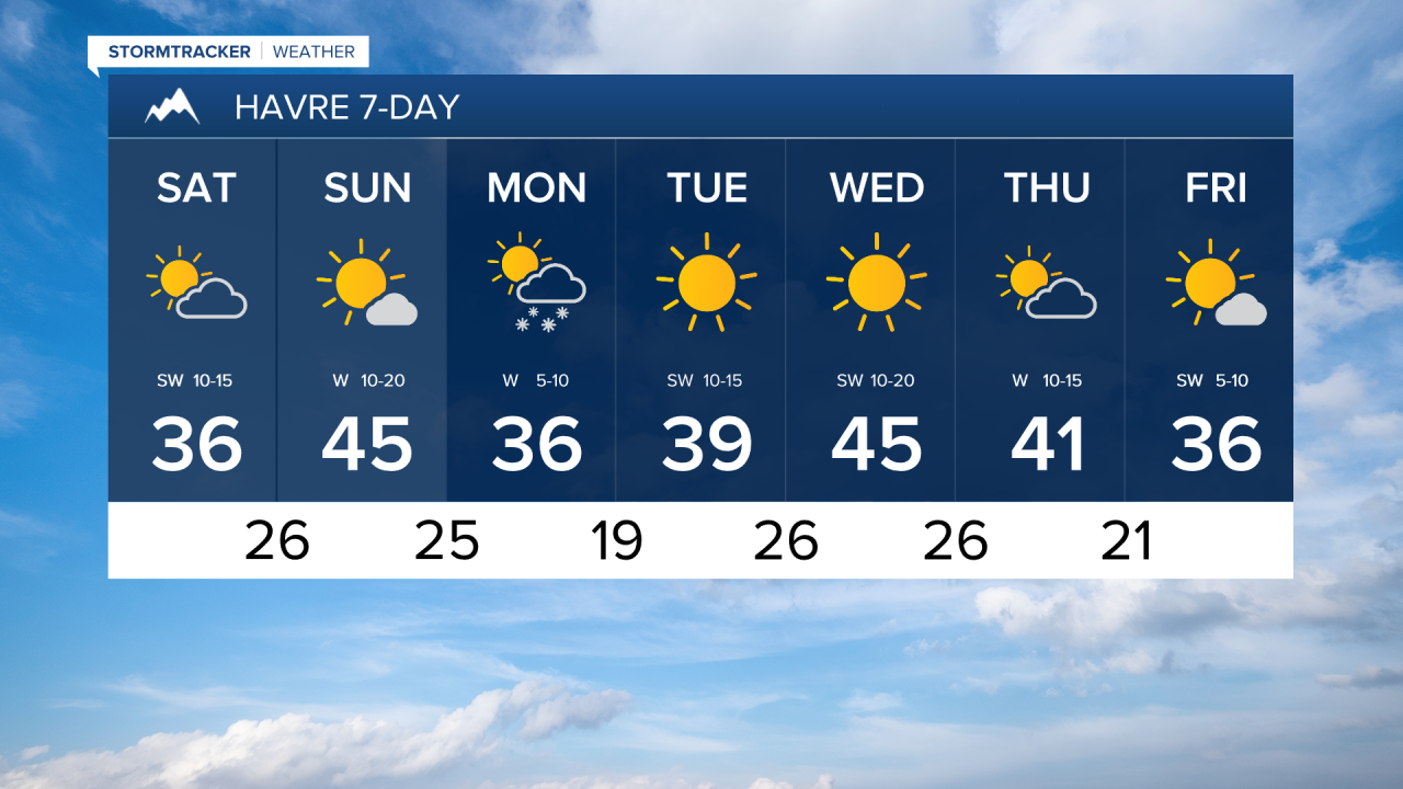
There are going to be some scattered snow showers around tonight as a disturbance works its way through our area. Little (a coating) to no snow accumulation is expected in most lower elevation locations. In the mountains, up to 3 inches of snow accumulation is possible tonight. We are also going to have decreasing clouds tonight and some areas of fog may develop later on tonight. It is also going to be chilly tonight as lows are going to be in the mid to upper teens and low to mid 20s, and it is going to be a bit breezy tonight along the Rocky Mountain Front and in the Judith Basin/Fergus County area as sustained wind speeds are going to be between 10 and 20 mph.
For tomorrow, we are going to have increasing clouds from west to east with some areas of fog around during the morning. Some isolated snow showers are also possible tomorrow morning and evening, but most locations are going to be dry. Along the Rocky Mountain Front, gusty winds are expected tomorrow as sustained wind speeds are going to be between 10 and 30 mph, and wind gusts over 40 mph are possible. East of the Rocky Mountain Front, it is going to be breezy tomorrow as sustained wind speeds are going to be between 10 and 20 mph, and wind gusts over 30 mph are possible. It is also going to be cool tomorrow as highs are going to be in the 30s in most locations.
On Sunday, we are going to have partly cloudy to mostly sunny skies and mostly dry conditions in north-central Montana, and we are going to have mostly cloudy skies with some scattered rain and snow showers around the Helena area (especially in the mountains) as another disturbance impacts our area. It is also going to be warmer on Sunday than it is going to be tomorrow as highs are going to be in the 40s and upper 30s in most locations.
Along the Rocky Mountain Front, windy conditions are expected tomorrow night and Sunday as sustained wind speeds are going to be between 25 and 45 mph, and wind gusts over 60 mph are expected. East of the Rocky Mountain Front, we are going to have gusty winds around tomorrow night and Sunday as sustained wind speeds are going to be between 10 and 30 mph, and wind gusts over 40 mph are possible.
Snow showers are then likely on Monday around the Helena area, and there are going to be scattered snow showers around on Monday in north-central Montana as another disturbance passes through our area, and light snow accumulations (a coating to 3 inches) are possible. We are also going to have mostly cloudy skies and cooler temperatures on Monday as highs are going to be in the 30s in most locations.
We are then going to have lots of sunshine and mainly dry conditions on Tuesday and Wednesday as high pressure is going to be in control of our weather. The temperatures are also going to warm up some over these two days as highs are going to be in the upper 30s and low to mid 40s on Tuesday, and the 40s and low 50s on Wednesday. It is also going to be a bit breezy on Tuesday as sustained wind speeds are going to be between 10 and 20 mph, and it is going to be breezy on Wednesday as sustained wind speeds are going to be between 10 and 25 mph.
We are then going to have increasing clouds on Thursday with a chance of snow and rain showers, generally during the afternoon/evening, as another disturbance begins to approach our area. We are then going to have decreasing clouds with some isolated snow showers around on Friday, generally during the morning, as this disturbance leaves our area. The temperatures are also going to cool down some over these two days as highs are going to be in the upper 30s and low to mid 40s on Thursday, and the 30s on Friday. It is also going to be a bit breezy on Thursday as sustained wind speeds are going to be between 10 and 20 mph.