A WINTER STORM WARNING is in effect for some of the mountains in southwestern and south-central Montana until 6pm Saturday or 6am Sunday.

A WINTER WEATHER ADVISORY is in effect for some of the mountains in southwestern Montana until 6pm Saturday.

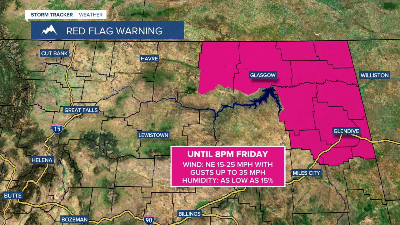
A RED FLAG WARNING is in effect for portions of northeastern Montana until 8pm Friday.
We are going to have mostly cloudy skies tonight with some scattered rain and mountain snow/rain showers around. It is also going to be cool tonight as lows are going to be in the mid to upper 30s and low to mid 40s, and it is going to be a bit breezy tonight in some areas as sustained wind speeds are going to be between 10 and 20 mph.
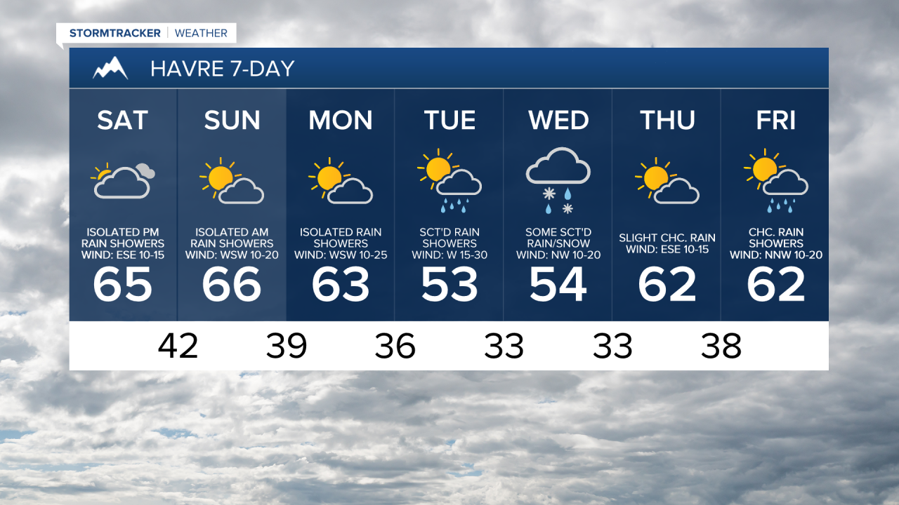
Rain and mountain snow/rain is then likely around Helena tomorrow, and there are going to be scattered areas of rain and mountain snow/rain around in north-central Montana tomorrow, mainly in locations west of a line from Havre to Lewistown and generally during the afternoon/evening, as a storm system continues to impact our area. We are also going to have mostly cloudy to overcast skies tomorrow. It is also going to be breezy in some areas tomorrow (especially east of I-15) as sustained wind speeds are going to be between 10 and 25 mph. Also, highs tomorrow are going to range from the mid 40s to the mid 60s, with the warmest temperatures in eastern portions of north-central Montana.
We are then going to have partly cloudy skies on Sunday with a few isolated rain showers around as this storm system leaves our area. We are also going to have gusty winds around on Sunday along the Rocky Mountain Front as sustained wind speeds are going to be between 15 and 35 mph, and it is going to be breezy on Sunday in some areas east of the Rocky Mountain Front as sustained wind speeds are going to be between 10 and 25 mph. It is also going to be warmer on Sunday than it is going to be tomorrow as highs are going to be in the mid to upper 50s and low to mid 60s.
There are then going to be scattered rain and mountain snow/rain showers around on Monday and Tuesday, especially in the higher elevations, as a couple more disturbances pass through our area. A little snow may also mix in with this rain in the lower elevations on Tuesday. We are also going to have partly cloudy skies on these two days.
It is also going to be breezy on Monday as sustained wind speeds are going to be between 10 and 25 mph. It is then going to be windy on Tuesday as sustained wind speeds are going to be between 15 and 30 mph. The temperatures are also going to cool down some between these two days as highs on Monday are going to be in the 50s and 60s and highs on Tuesday are going to be in the 50s and mid to upper 40s.
There are then going to be scattered areas of rain and snow around on Wednesday as a storm system works its way through our area. We are also going to have partly to mostly cloudy skies and cool temperatures on Wednesday as highs are going to be in the 50s and mid to upper 40s in most locations. There is also going to be a bit of a breeze around on Wednesday as sustained wind speeds are going to be between 10 and 20 mph.
The temperatures are then going to warm back up for the end of next week as highs are going to be in the mid to upper 50s and low to mid 60s on Thursday and Friday. It is also going to be a bit breezy in some areas on these two days as sustained wind speeds are going to be between 10 and 20 mph. We are also going to have partly cloudy skies on these two days with isolated rain showers around on Thursday, generally in the mountains, and some scattered rain showers around on Friday, especially in the mountains.