It is going to continue to be breezy this evening as sustained wind speeds are going to be between 10 and 25 mph. There is then going to be a little bit of a breeze around tonight, especially before midnight, as sustained wind speeds are going to be between 5 and 15 mph. A Lake Wind Advisory also remains in effect for Fort Peck Lake until 12am tonight, and a Red Flag Warning remains in effect for most of eastern Montana until 10pm tonight. We are also going to have partly cloudy to mostly clear skies tonight with a chance of a few rain showers in locations east of I-15 as a weak disturbance passes through our area. Pleasant temperatures are also expected tonight as lows are going to be in the 50s in most locations.


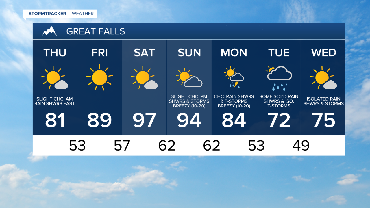
For tomorrow, we are going to have mostly to mainly sunny skies with a slight chance of rain showers during the morning in locations east of I-15. It is also going to be cooler tomorrow than it was today as highs are going to range from the mid 70s to the mid 80s. There is also going to be a bit of a breeze around tomorrow, especially during the afternoon and evening, in eastern Montana as sustained wind speeds are going to be between 10 and 20 mph.
Mainly sunny skies and dry conditions are then expected on Friday, and partly cloudy to mostly sunny skies and mainly dry conditions are expected on Saturday as high pressure is going to be in control of our weather. We are then going to have partly cloudy skies with a slight chance of PM rain showers and thunderstorms on Sunday as some monsoonal moisture tries to work its way into our area.
It is also going to be very warm on Friday as highs are going to be in the mid to upper 80s and low 90s, and it is going to be hot this weekend as highs are going to be in the 90s. Breezy conditions are also expected on Sunday, especially during the afternoon and evening, as sustained wind speeds are going to be between 10 and 20 mph.
On Monday, we are going to have partly cloudy skies with a chance of rain showers and thunderstorms, generally during the afternoon and evening, as some monsoonal moisture works its way into our area. There are then going to be some scattered rain showers and isolated thunderstorms around on Tuesday as a disturbance passes through our area. The temperatures are also going to cool down a lot over these two days as highs on Monday are going to be in the 80s, and highs on Tuesday are going to be in the low to mid 70s. Breezy conditions are also expected on Monday, especially during the afternoon and evening, as sustained wind speeds are going to be between 10 and 20 mph.
We are then going to have partly cloudy to mostly sunny skies with a few isolated rain showers and thunderstorms around next Wednesday. Pleasant temperatures are also in the forecast for next Wednesday as highs are going to be in the mid 70s in most locations.