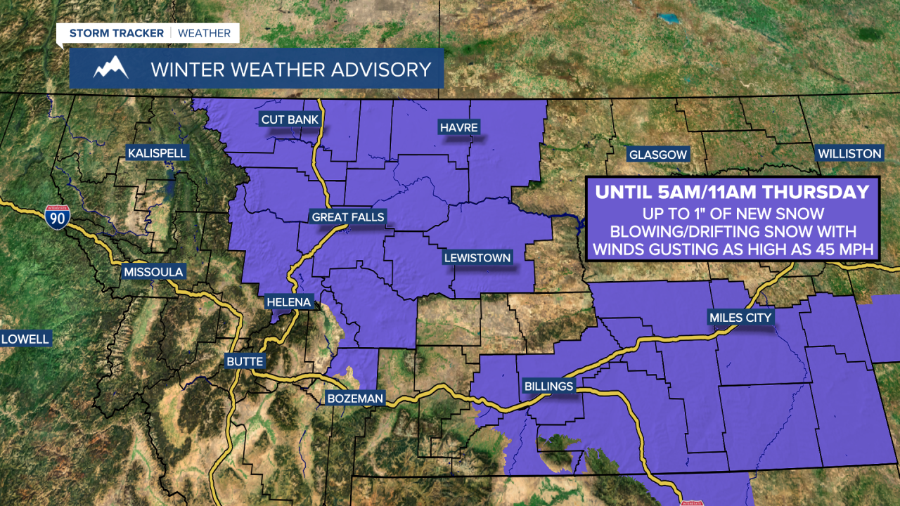
A WINTER WEATHER ADVISORY is in effect for most of central and north-central Montana until 5am/11am Thursday. Up to 1 inch of new snow accumulation is possible. Blowing snow is also expected as winds are going to be gusting as high as 45 mph.
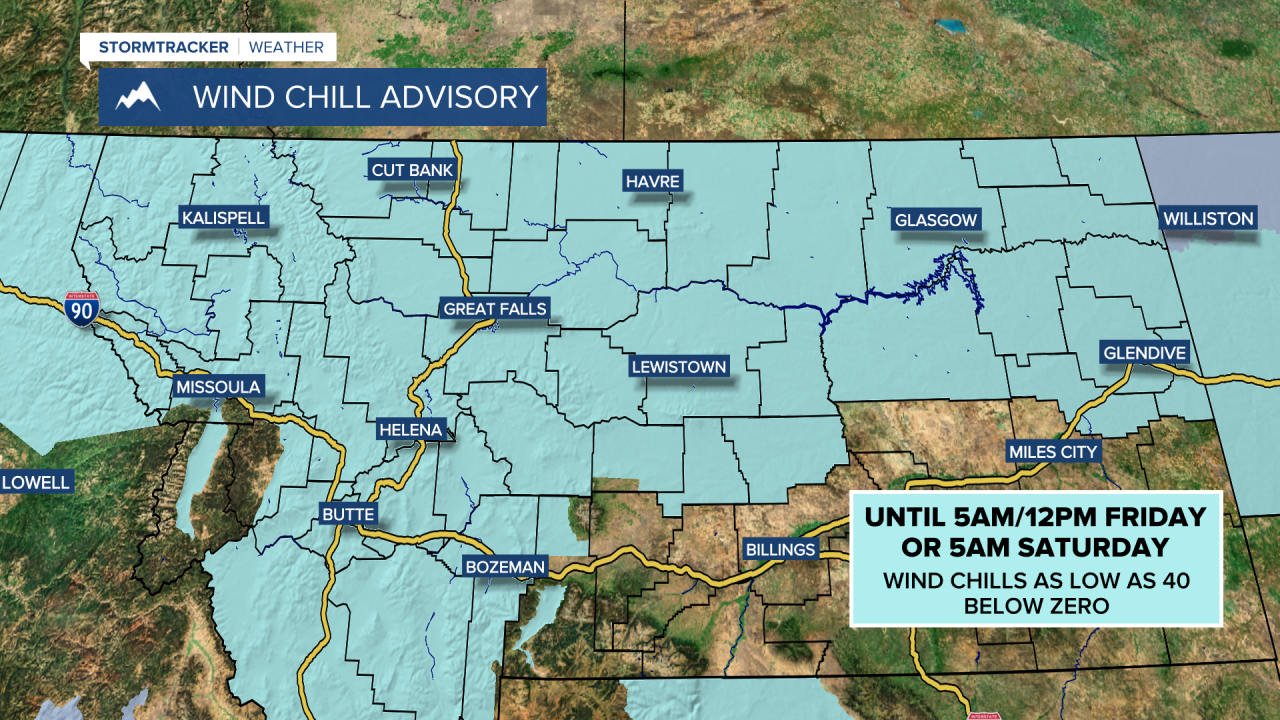
A WIND CHILL ADVISORY is in effect for all of central and north-central Montana until 5am/12pm Friday or 5am Saturday depending on your exact location. Wind chills as low as 40 below zero are possible.
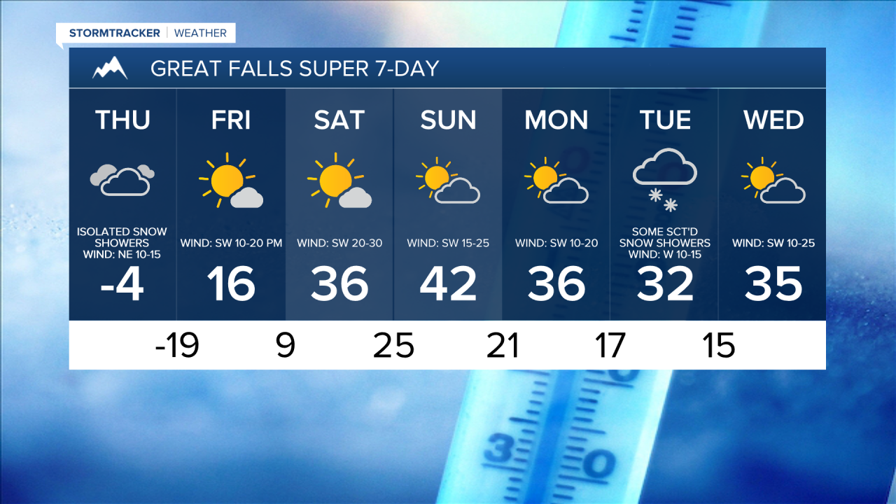
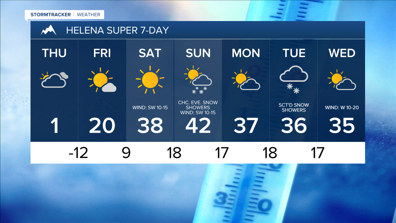
There are going to be areas of primarily light snow around tonight, and there are going to be some isolated snow showers around tomorrow as a storm system departs our area. Light additional snow accumulations of up to an inch are possible. We are also going to have mostly cloudy to overcast skies tonight and mostly cloudy skies tomorrow.
It is also going to be breezy tonight and tomorrow along the Continental Divide and along the Rocky Mountain Front as wind gusts up to 40 mph are going to be possible at times. East of the Rocky Mountain Front, there is just going to be a little breeze around tonight and tomorrow as sustained wind speeds are going to be between 5 and 15 mph. This wind is also going to cause there to be areas of blowing and drifting snow around.
Subzero temperatures are also expected tonight through Friday morning as lows tonight are going to be in the -0s and -10s; highs tomorrow are going to be in the -0s; and lows tomorrow night are going to be in the -10s and -20s. Dangerous wind chills are also expected through Friday morning as wind chills as low as 40 below zero are possible. If you are going to be outside at all over the next couple of days, then make sure you bundle up!
On Friday, we are going to have partly cloudy to mostly sunny skies and mostly dry conditions. Along the Hi-Line and in northeastern Montana, it is going to be another frigid day on Friday as highs are going to be in the 0s and -0s. South of the Hi-Line, it is going to be warmer on Friday as highs are going to be in the teens. The wind is also going to increase later in the day on Friday, especially along and just east of the Continental Divide.
The temperatures are then going to continue to warm up this weekend as highs are going to be in the 20s and 30s on Saturday and the 30s and low to mid 40s on Sunday. These warmer temperatures are going to be accompanied by a gusty to strong southwesterly breeze though as sustained wind speeds are going to be between 15 and 35 mph, and wind gusts over 50 mph are going to be possible at times, especially on Saturday. We are also going to have mostly sunny skies and dry conditions on Saturday. We are then going to have increasing clouds on Sunday with a chance of PM snow showers along the Continental Divide and around the Helena area as a cold front approaches our area.
Partly cloudy skies and mainly dry conditions are then expected on Monday. There are then going to be some scattered snow showers around on Tuesday, especially during the afternoon and evening, as a disturbance passes through our area. We are then going to have partly cloudy skies on Wednesday with some isolated snow showers around.
It is also going to be chilly from Monday through Wednesday as highs are going to be in the 30s in most locations. Breezy conditions are also expected on Monday and Wednesday as sustained wind speeds are going to be between 10 and 25 mph.