A WINTER STORM WARNING is in effect for Glacier National Park and the Rocky Mountain Front from 6pm Saturday until 12pm Monday.

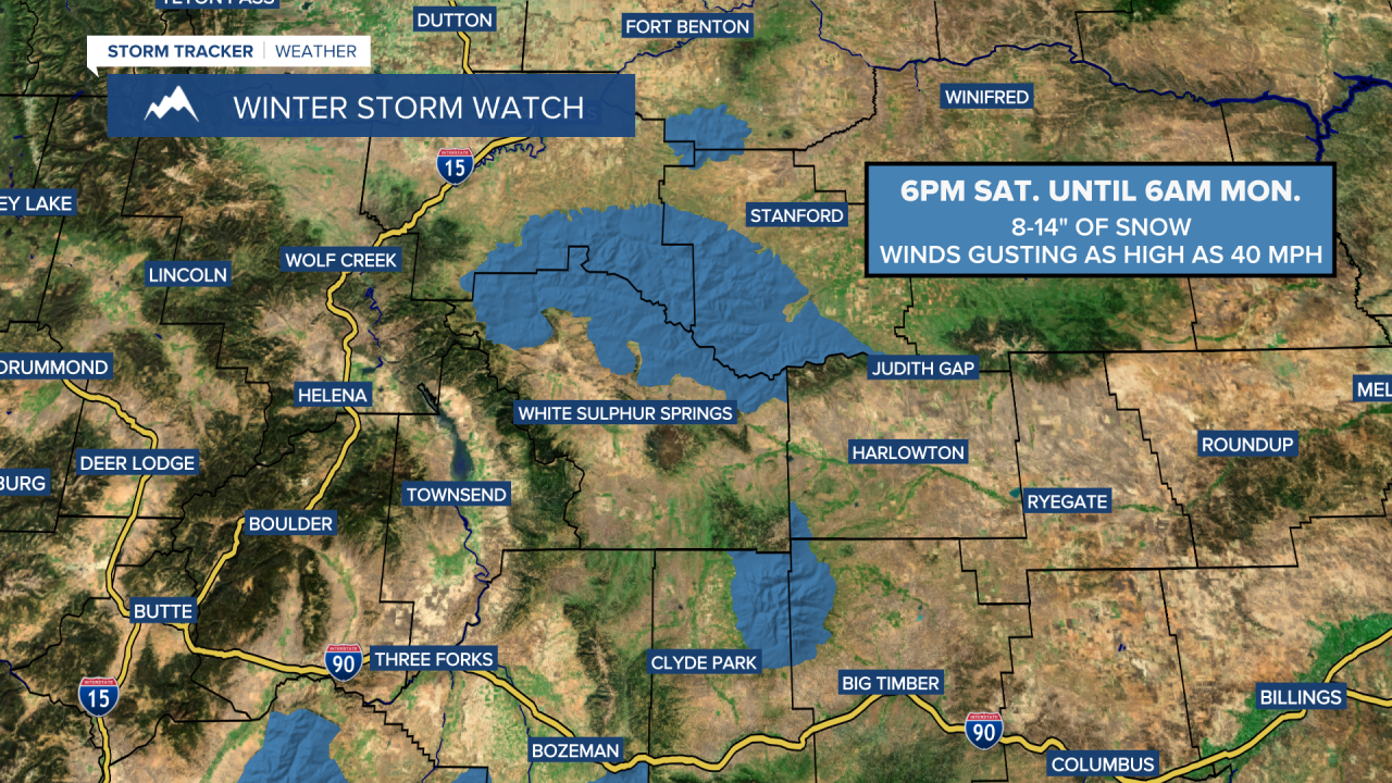
A WINTER STORM WATCH is in effect for the Highwoods and Little Belts from 6pm Saturday until 6am Monday.
An active few days of weather ahead as an upper-level trough slowly works its way through our area.
Here is the detailed forecast:
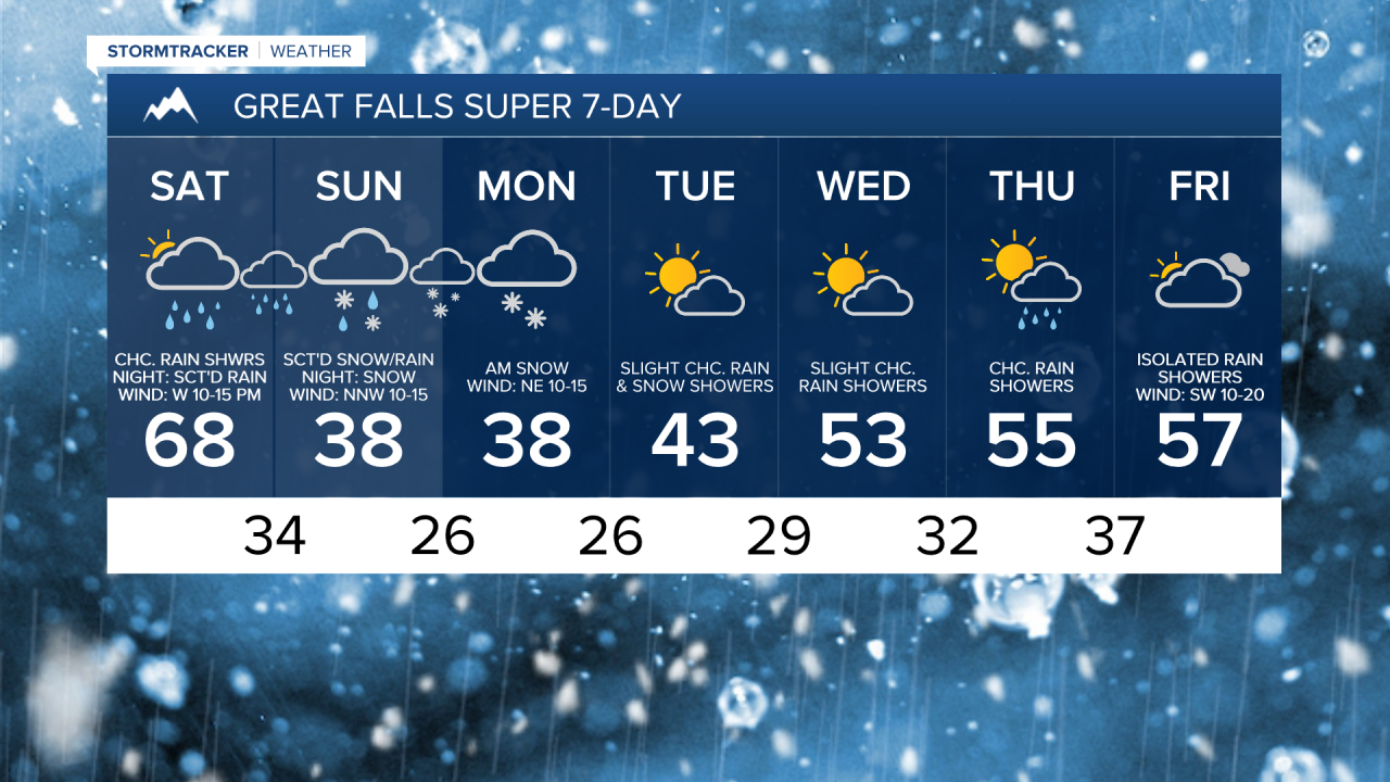
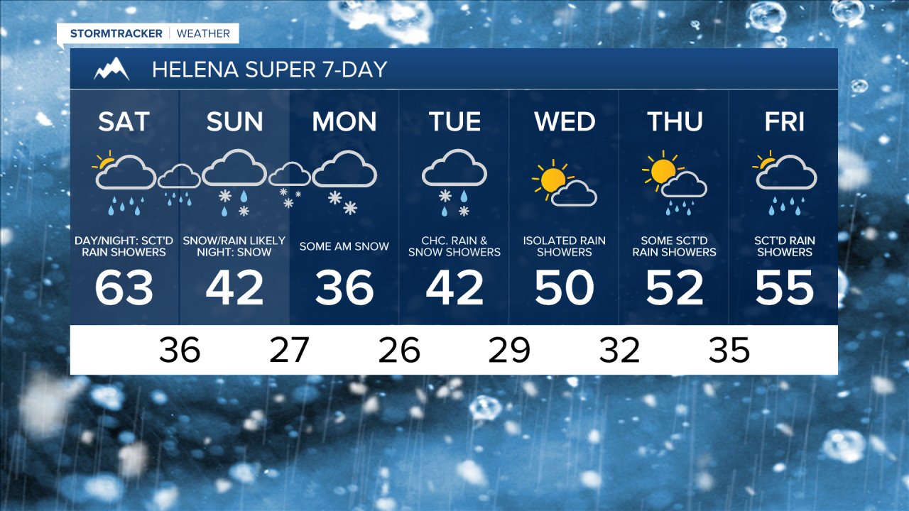
On Saturday, we are going to have partly to mostly cloudy skies with scattered rain showers and isolated thunderstorms around, especially during the afternoon/evening and especially in locations east of I-15, as a cold front passes through the state. There is going to be a good amount of dry time tomorrow, but have the rain jacket handy if you are going to be doing anything outdoors.
There are then going to be areas of rain and mountain snow around tomorrow night as this cold front departs our area and as another cold front from Canada begins to pass through our area. Snow levels will fall as we go through tomorrow night and will be as low as about 3000 feet by Sunday morning, so some lower elevation locations will see some snow later tomorrow night.
On Sunday, mountain snow is likely and there are going to be areas of snow and rain around in the lower elevations, especially during the morning and evening, with snow levels down to the plains and valleys. A more widespread area of snow will then impact a lot of western and central Montana Sunday evening through Monday morning, and this is when a lot of lower elevation locations, including Great Falls and Helena, will likely receive their first accumulating snowfall of the season (if we don’t see any accumulation during the day on Sunday). As we go through Monday, the snow will taper off, with just a few snow showers around during the afternoon and evening.
The mountains will see a good amount of snow Saturday evening through midday Monday. In Glacier National Park and along the Rocky Mountain Front, up to 20” of snow is possible on the highest peaks; 5-16” of snow is possible above 6000 feet; and up to 7” of snow is possible below 6000 feet. In the Little Belts and the Highwoods, 8-14” of snow is possible. In the other mountain ranges in central and north-central Montana, up to 8” of snow is possible.
Difficult travel is expected at and above mountain pass level from Saturday night through Monday morning, so please use extreme caution if you will be traveling over any of the mountain passes or in the mountains during this timeframe.
In the lower elevations, up to 3” of snow is possible through midday Monday, with up to 6” of snow possible in locations that are near the mountains. Although some lower elevations may receive accumulating snow during the day on Sunday, the bulk of the lower elevation snow accumulation will occur Sunday evening through Monday morning, so it may be a slick morning commute in some areas on Monday.

The temperatures will start to cool down tomorrow as highs are going to range from the mid 50s along the Rocky Mountain Front to the upper 70s in northeastern Montana. It is then going to be significantly colder for everyone Sunday and Monday as highs are going to be in the 30s and 40s (warmer the further east of I-15 you go). It is also going to be breezy tomorrow in western portions of north-central Montana, especially during the afternoon and evening, as sustained wind speeds are going to be between 10 and 25 mph. Elsewhere, it is going to be a little breezy tomorrow as sustained wind speeds are going to be between 5 and 20 mph.
Widespread gusty winds are then expected tomorrow night as gusts up to 40 mph are possible. Gusty winds (gusts up to 40 mph) will continue on Sunday in eastern portions of north-central Montana, while the wind will weaken as the day goes on in western portions of north-central Montana. It is then going to be a little breezy (5-20 mph) on Monday.
Temperatures will gradually warm back up as we go through next week as highs are going to be in the 40s and mid to upper 30s on Tuesday; the mid to upper 40s and low to mid 50s on Wednesday; and the 50s and upper 40s on Thursday and Friday.
On Tuesday and Wednesday, we are going to have partly cloudy skies with a few scattered rain and snow showers around Helena and some isolated rain and snow showers around in north-central Montana. We are then going to have a chance to see some more scattered rain and mountain snow showers on Thursday and Friday as we remain in an unsettled weather pattern.