


WINTER WEATHER ALERTS
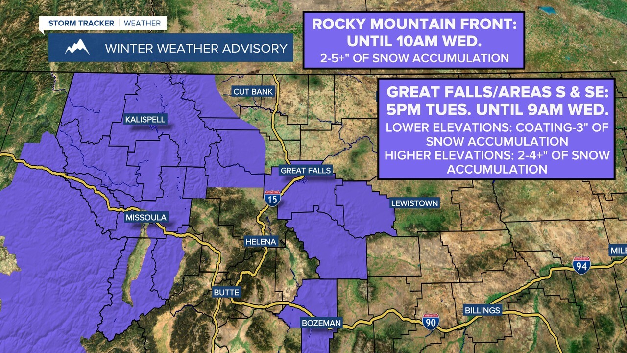
A Winter Weather Advisory is in effect for Cascade County (including Great Falls), Judith Basin County, and Meagher County from 5 pm on Tuesday until 9 am on Wednesday.
A coating to 3" of snow accumulation is expected in the lower elevations, while 2-4+" of snow accumulation is expected in the higher elevations.
A Winter Weather Advisory also remains in effect until 10am on Wednesday for the Rocky Mountain Front. Between 2 to 5" of snow accumulation is expected, with even higher amounts expected in the highest elevations.
If you are traveling, please be careful as roads are going to be slick, especially from this evening through tomorrow morning.
TODAY: We will have temperatures in the mid to upper 40s. Mostly cloudy conditions can be expected as we will have increasing cloud cover into the afternoon. There will be a chance of some showers and upper elevation snow showers in Western Montana. For tomorrow night, there will be snow showers in our area and there is a chance to pick up a dusting to an inch of snow with higher amounts in the upper elevations. Winds will be out of the West at 5-15 mph.
TONIGHT: We will have mostly overcast skies heading into tonight. Temperatures will get down into the low to upper 20s. The winds will be calm out of the Southwest at around 5 mph. There will be continued snow showers throughout the overnight hours.
TOMORROW: Temperatures look to cool back down on either side of the 40-degree mark. We look to be under mostly cloudy skies to start but will have decreasing cloud cover by afternoon. There is a chance for some scattered snow showers at this point during the morning hours. Winds will be light and variable around 5 mph.
THURSDAY: Thanksgiving will feature windy conditions and temperatures on the rise once again. High’s will top out in the low to mid 50s. The winds will be out of the Southwest at 20-30 mph with gusts of 40-50 mph. We look to be under mostly cloudy conditions but there is no major precipitation threat expect for an isolated shower to the South.
FRIDAY: We look to stay very mild for the end of the week with highs reaching into the upper 50s in many locations. We will also keep the winds out of the Southwest at 15-25 mph with gusts to 40 mph. We will be under mostly cloudy skies with a chance for some isolated showers.
SATURDAY & SUNDAY: Temperatures will stay very warm for this time of year heading into the weekend with highs ranging from the lower to the upper 50s and some areas could be pushing into the low 60s. We look to be seeing more sun shine heading into the weekend as we will be under partly cloudy skies. At this point, there is no threat for any precipitation. The winds do die down a little bit but will stay breezy throughout the weekend out of the Southwest at 10-15 mph with gusts to 30 mph.
MONDAY: Conditions look to be mostly overcast to start off the week. We will also look to stay warmer than average for this time of year with high temperatures getting into the low to mid 50s. Winds also look to calm down at this point being light and variable around 5 mph.
