We are going to have mainly clear skies and dry conditions tonight. We are also going to have gusty winds around tonight in portions of central Montana as sustained wind speeds are going to be between 10 and 25 mph, and wind gusts over 40 mph are going to be possible at times. It is also going to be chilly tonight in the valleys and mountains as lows are going to be in the single digits and teens, and it is going to be cool tonight in the plains as lows are going to be in the 20s and low 30s.
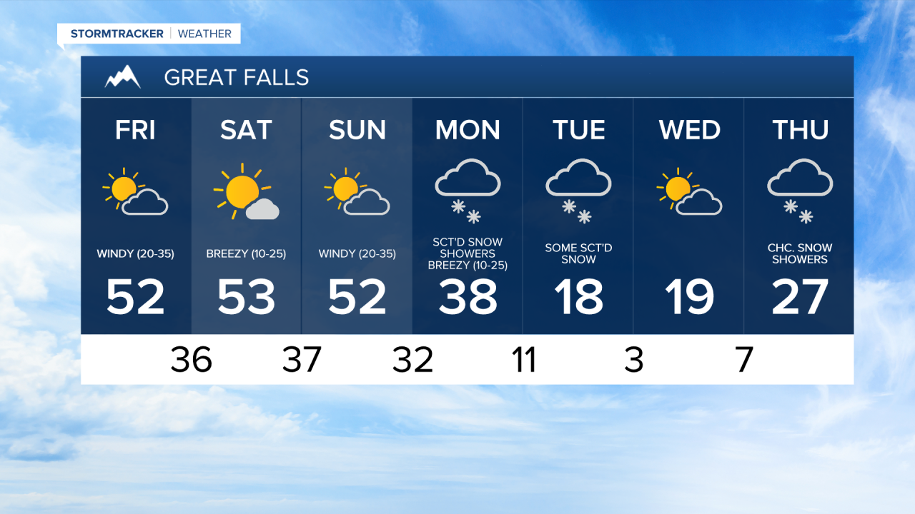
For tomorrow and this weekend, we are going to have partly cloudy to mostly sunny skies and dry conditions as high pressure is generally going to be in control of our weather. A few rain and snow showers are possible Sunday afternoon/evening along the Continental Divide though as a storm system begins to approach our area.
It is also going to be mild in the plains tomorrow, Saturday, and Sunday as highs are going to be in the mid to upper 40s and low to mid 50s. In the valleys and mountains, it is going to be a little colder than it is going to be in the plains, but it is still going to be pretty nice over the next three days as highs are going to be in the mid to upper 30s and low to mid 40s.
We are also going to have strong/gusty winds around tomorrow and Sunday as sustained wind speeds are going to be between 15 and 35 mph, and wind gusts over 50 mph are going to be possible at times. On Saturday, we are going to have gusty winds around as sustained wind speeds are going to be between 10 and 25 mph, and wind gusts up to 40 mph are going to be possible at times.
There are then going to be scattered areas of snow around on Monday and Tuesday, especially from Monday afternoon through Tuesday morning, as a storm system passes through our area. A few inches of snow accumulation is possible in the lower elevations, and several inches of snow accumulation is possible in the higher elevations.
The temperatures are also going to cool down a lot early next week as highs on Monday are going to be in the 30s in most locations, and highs on Tuesday are going to be in the teens and low 20s in most locations. It is also going to be breezy on Monday as sustained wind speeds are going to be between 10 and 25 mph. There is then going to be a little bit of a breeze around on Tuesday as sustained wind speeds are going to be between 5 and 20 mph.
On Wednesday, we are going to have partly cloudy skies with a slight chance of snow showers as we are going to be in between storm systems. There are then going to be some scattered areas of snow around on Thursday, generally during the afternoon and evening, as the next storm system begins to approach our area. It is also going to be chilly on these two days as highs on Wednesday are going to be in the mid to upper teens and low 20s, and highs on Thursday are going to be in the 20s. There is also going to be a little bit of a breeze around on these two days as sustained wind speeds are going to be between 5 and 20 mph.