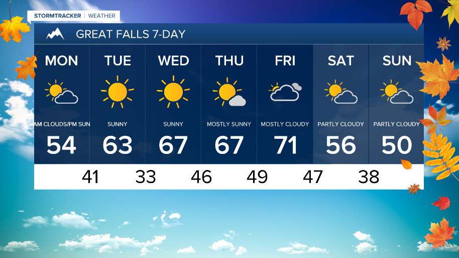
WEATHER DISCUSSION: Most of the region saw gusty winds through most of today along with slightly warming temperatures. Tonight, expect breezy conditions with low temperatures in the 30s and 40s with mostly cloudy skies. Mountain snow and some isolated lower elevation rain is expected.

Upper level troughing moving east will continue to bring impactful weather to the region through the next 24 hours or so before shifting away from the region. Initial impacts include gusty winds this evening with the strongest gusts over the plains. High Wind Warnings are in effect for portions of the Rocky Mountain Front through Cascade County through 8 pm this evening warning of gusts as high as 60-75 mph.
WATCH THE FORECAST VIDEO:
Precipitation chances resume tonight of mountain snow and lower elevation rain. The main precipitation band will continue eastward this evening. Most precipitation that lingers into tonight is expected to be light. Snow levels will continue to fall with the highest snow amounts forecasted above pass level for most locations. though areas such as Kings Hill Pass are likely to see accumulating snow. Winter Weather Advisories for most mountain locations will be in effect midnight tonight through noon Monday. Locations like Logan Pass could see 6 inches of snow while 2-4 inches are likely for Neihart and Monarch locations (up to 7 inches for Kings Hill Pass).

As this system begins to push out of the region, a northwesterly flow aloft develops Monday morning. This means that widespread, gusty winds are expected with wind gusts up to 50 mph for Central and North Central portions. Expect high temperatures on Monday back in the 40s and 50s with mostly cloudy skies that will gradually become sunny. Chances of rain and mountain snow continue throughout the afternoon.
Weak, upper-level ridging slowly builds in toward the middle of the week which will allow for a warming trend with largely dry conditions. Temperatures are expected to be above average during this period with most locations seeing high temperatures in the 60s and 70s. Breezy conditions are likely towards the back half of the week.