Today has been the nicest day of the week so far as many of us were finally able to see some sunshine, a lot of locations were dry, the wind wasn’t too strong, and it was the warmest day of the week so far as highs were in the upper 40s, 50s, and low 60s in most locations.
Tonight, we are going to have partly cloudy skies (via increasing clouds) and mainly dry conditions. The wind is also going to increase tonight, with windy conditions (gusts up to 50 mph) developing along the Rocky Mountain Front and breezy conditions (gusts up to 30 mph) developing out across the plains. It is also going to be cool tonight as lows are going to be in the mid to upper 30s and low to mid 40s.
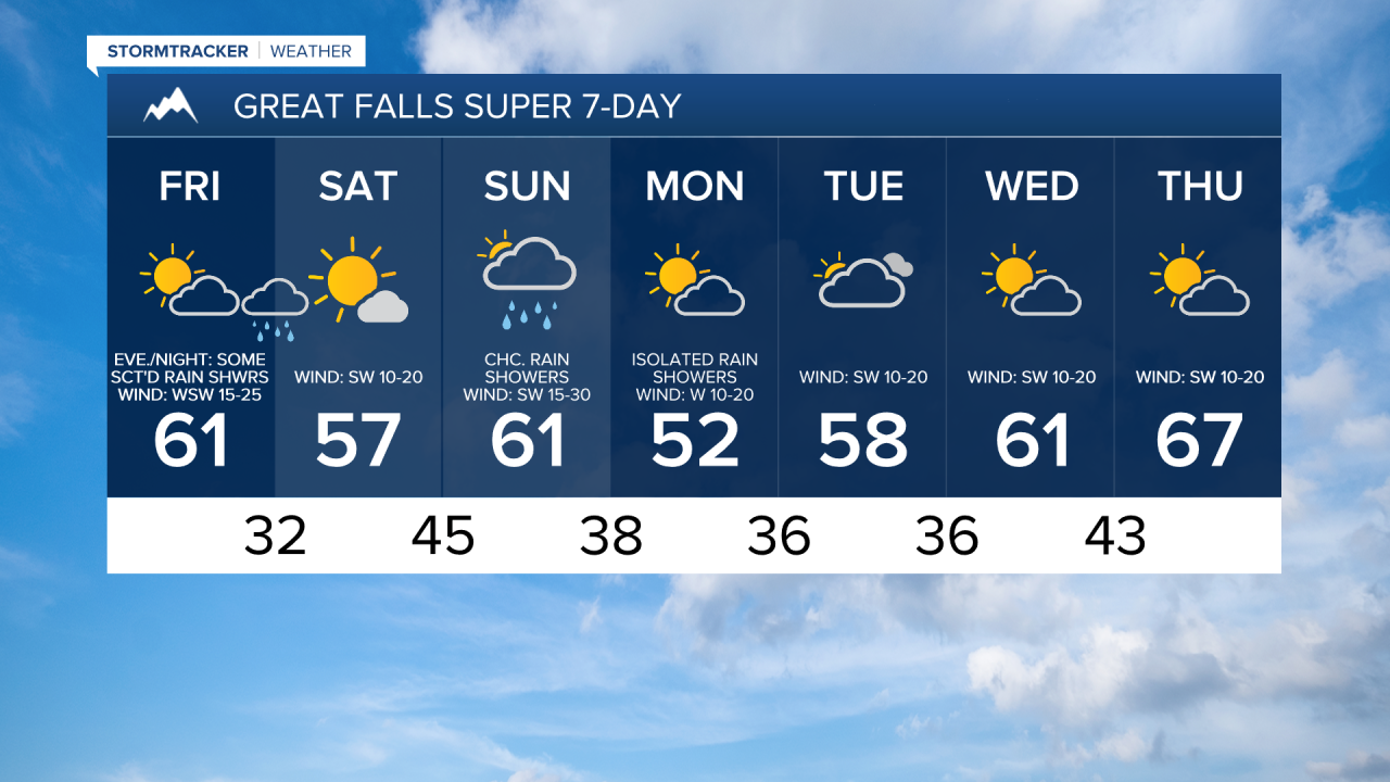
Here is the detailed forecast:
Tomorrow will be a windy day along the Rocky Mountain Front as sustained wind speeds are going to be between 15 and 35 mph, and wind gusts over 50 mph are possible. Out across the plains, gusty winds are expected tomorrow as sustained wind speeds are going to be between 10 and 30 mph, and wind gusts over 40 mph are possible. In the valleys, including in Helena, it is going to be breezy tomorrow afternoon/evening as sustained wind speeds are going to be between 10 and 20 mph.
We are also going to have a mixture of sun and clouds and pleasant temperatures tomorrow as highs are going to be in the upper 40s, 50s, and low 60s in most spots. Tomorrow will start off dry, but there are going to be scattered rain and mountain snow showers around late tomorrow afternoon, tomorrow evening, and tomorrow night (generally before 3am) as a clipper passes through our area. A brief changeover to snow will also be possible in some lower elevation locations, but no snow accumulation is expected. In the mountains, up to 4” of snow is possible by sunrise on Saturday.

Saturday will be a beautiful day with mostly sunny skies, dry conditions, and pleasant temperatures as highs are going to be in the 50s in most locations. It is also going to be breezy on Saturday as sustained wind speeds are going to be between 10 and 25 mph, with the strongest wind along the Rocky Mountain Front.
The next storm system will begin to impact the state on Sunday. On Sunday, we are going to have mostly cloudy skies with rain and mountain snow showers likely around Helena and some scattered rain and mountain snow showers around in north-central Montana. It is also going to be windy on Sunday as sustained wind speeds are going to be between 15 and 35 mph, and wind gusts over 50 mph are possible, with the strongest wind occurring during the afternoon and evening. We are also going to have pleasant temperatures again on Sunday as highs are going to be in the 50s and low to mid 60s.
On Monday, there are going to continue to be a few scattered rain and mountain snow showers around, generally in the mountains and in locations east of I-15, as Sunday’s storm system leaves our area. It is also going to be breezy and cooler on Monday as sustained wind speeds are going to be between 10 and 20 mph, and highs are going to be in the upper 40s and low to mid 50s.
Nice weather is then expected on Tuesday, Wednesday, and Thursday, as we are going to have partly cloudy skies, mainly dry conditions, and warming temperatures as highs are going to be in the 50s and low 60s on Tuesday; the upper 50s and low to mid 60s on Wednesday; and the 60s on Thursday. It is also going to be breezy in some areas on these three days as sustained wind speeds are going to be between 10 and 25 mph.