A LAKE WIND ADVISORY is in effect for Fort Peck Lake from 12pm Tuesday until 12am Wednesday. Sustained wind speeds are going to be between 15 and 25 mph, and wind gusts up to 35 mph are going to be possible at times.

We are going to have partly cloudy skies and mainly dry conditions tonight. It is also going to be cool tonight as lows are going to be in the 30s and low 40s. There is also going to be a little bit of a breeze around tonight, especially in northeastern Montana, as sustained wind speeds are going to be between 5 and 20 mph.
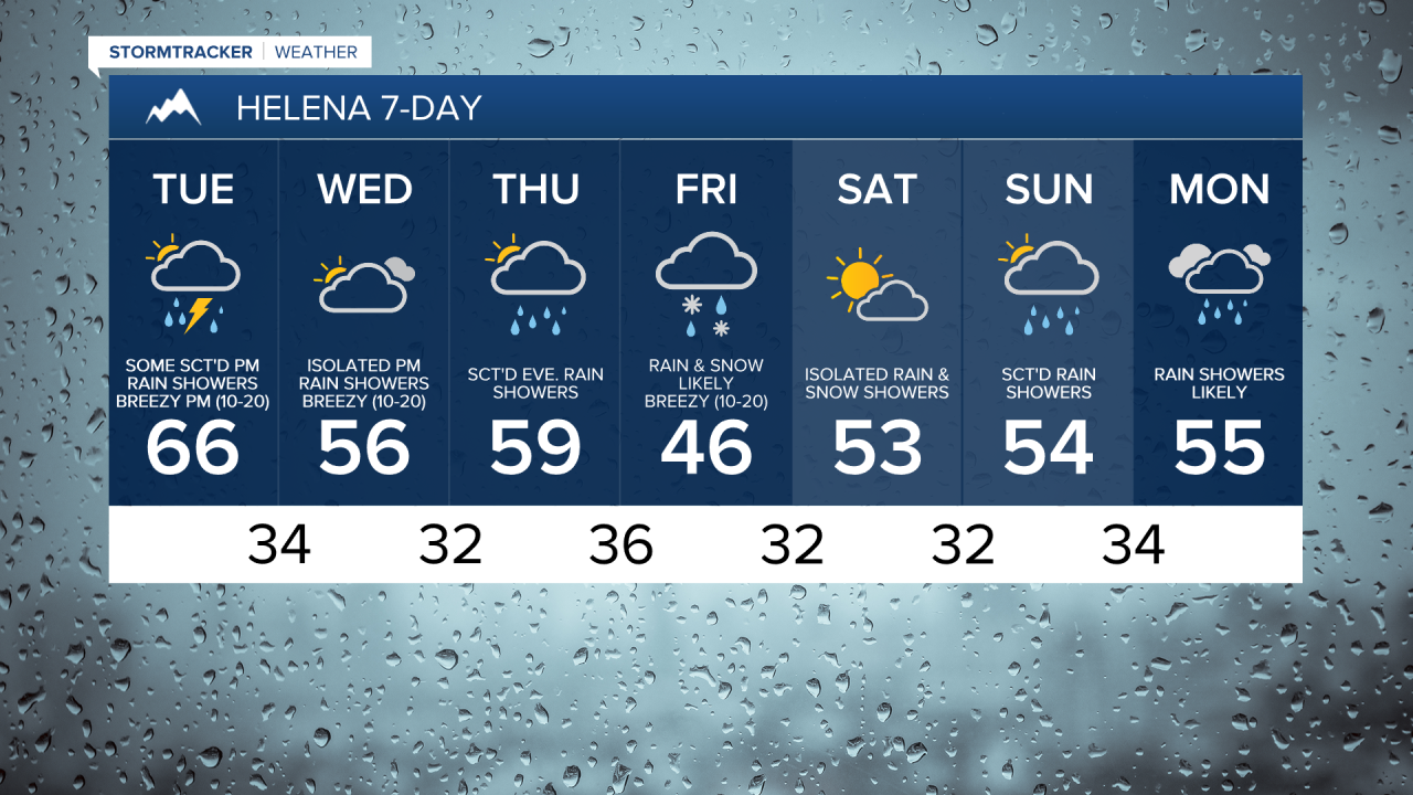
For tomorrow, we are going to have partly to mostly cloudy skies and mild temperatures as highs are going to be in the upper 50s, 60s, and low 70s in most locations. There are also going to be scattered rain showers and isolated thunderstorms around late tomorrow afternoon, tomorrow evening, and early tomorrow night as a cold front passes through our area. We are also going to have gusty winds around tomorrow, especially during the afternoon and evening, and tomorrow night, especially before midnight. Sustained wind speeds are going to be between 10 and 30 mph, and wind gusts over 40 mph are going to be possible at times.
It is then going to be breezy and cooler on Wednesday as sustained wind speeds are going to be between 10 and 25 mph, and high temperatures are going to be in the 50s in most locations. We are also going to have partly to mostly cloudy skies on Wednesday, and there are going to be a few scattered rain showers and isolated thunderstorms around late Wednesday afternoon and Wednesday evening in locations south and east of Great Falls as a disturbance passes by our area to the southeast.
On Thursday, we are going to have partly to mostly cloudy skies with some scattered evening rain and mountain rain/snow showers around, generally in south-central Montana, as a storm system begins to approach our area. A mix of rain and snow is then likely on Friday as this storm system passes through our area. The temperatures are also going to cool down a lot between Thursday and Friday as highs on Thursday are going to be in the mid to upper 50s and low 60s, and highs on Friday are going to be in the 40s. It is also going to be breezy on Friday as sustained wind speeds are going to be between 10 and 20 mph.
We are then going to have partly cloudy skies on Saturday with some isolated rain and snow showers around as this storm system leaves our area and as a disturbance begins to approach our area. There are then going to be some scattered rain and mountain snow showers around on Sunday and Monday as a couple disturbances pass through our area. Some wet snow is also possible in the lower elevations Sunday morning and Monday morning. It is also going to be cool on Saturday, Sunday, and Monday as highs are going to be in the upper 40s and low to mid 50s in most locations.
TRENDING ARTICLES
- Harlem teacher allegedly raped student
- Shooting victim near Essex identified
- Great Falls man dies after I-15 crash
- Ice Breaker race: video + results
- 9th DUI charge for Cascade County man