An AIR QUALITY ALERT is in effect for northeastern Montana until at least 9am on Wednesday.
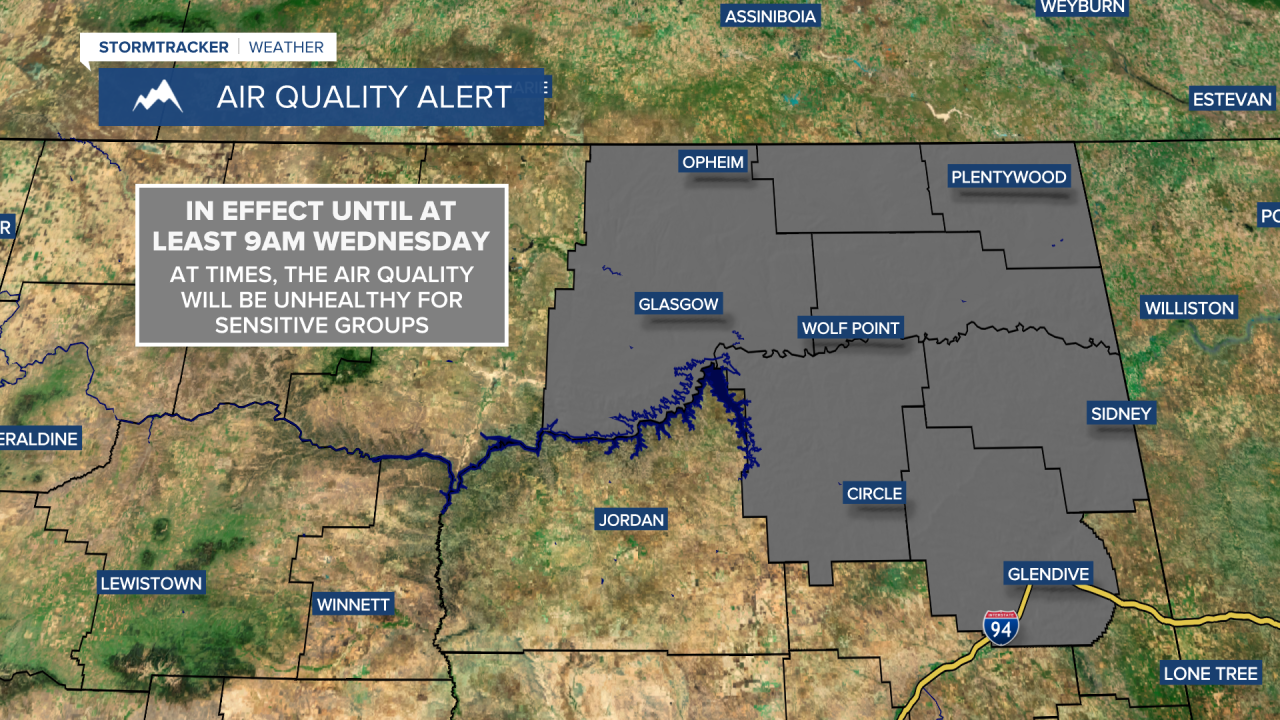
Widespread haze and areas of smoke are expected through Thursday morning as northwest flow aloft continues to bring Canadian wildfire smoke into Montana. The haze will become thicker as we go through this evening and tonight, and it will be very hazy tomorrow. The air quality tonight and tomorrow will be in the “moderate” or “unhealthy for sensitive groups” categories in most locations.
A thicker area of smoke will arrive in the Golden Triangle tomorrow evening and will become more widespread throughout central and western Montana tomorrow night. This thicker smoke will likely make the air quality unhealthy or very unhealthy for everyone for a period of time. It will be very smoky in a lot of areas Thursday morning, including around Great Falls, Helena, and Lewistown, but the haze/smoke will decrease and the air quality will improve from north to south as we go through the day.
If you are sensitive to smoke being in the air, then make sure you limit your time outdoors tonight and tomorrow. Everyone should then limit their time outdoors tomorrow night and Thursday morning as that thicker plume of smoke impacts our area.
FULL FORECAST:
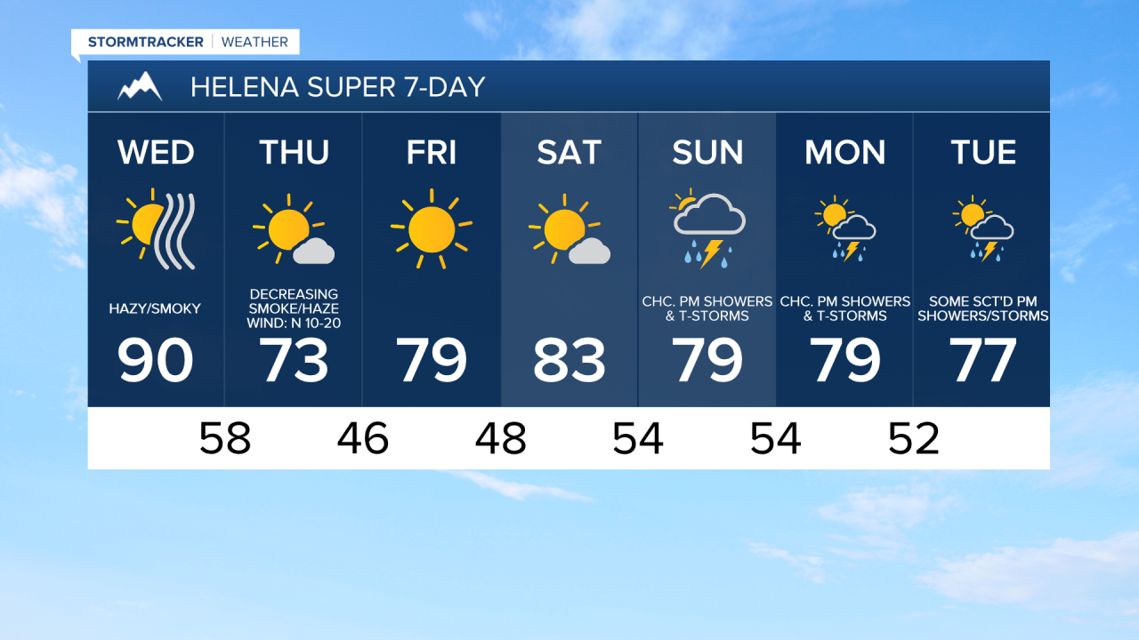
Tonight, we are going to have mostly clear skies and pleasant temperatures as lows are going to be in the mid to upper 40s and low to mid 50s, with the coldest temperatures along the Hi-Line. Tomorrow, we are going to have partly to mostly sunny skies, with more cloud cover the further east in north-central Montana you go. It will also be hot again tomorrow in western portions of north-central Montana and around Helena as highs are going to be in the mid to upper 80s and low 90s. In eastern portions of north-central Montana, it will be cooler tomorrow as highs are going to be in the mid to upper 70s and low 80s. It will also be a bit breezy tomorrow along the Rocky Mountain Front/the Divide and around the Little Belts as sustained wind speeds are going to be between 10 and 20 mph.
A cold front will then pass through our area on Thursday bringing us cooler temperatures and gusty winds. Highs on Thursday are only going to be in the mid to upper 60s and low to mid 70s, and lows Thursday night are going to be in the mid to upper 30s and low to mid 40s. There will be some areas of frost around Friday morning, especially along the Hi-Line and near the mountains, so make sure you take the necessary precautions to protect any sensitive vegetation that you may have.
It is also going to be breezy on Thursday in western portions of north-central Montana (west of a line from Havre to Lewistown) as sustained wind speeds are going to be between 10 and 20 mph, and wind gusts over 30 mph are possible. In eastern portions of north-central Montana (around and east of a line from Havre to Lewistown), it is going to be windy on Thursday as sustained wind speeds are going to be between 15 and 30 mph, and wind gusts up to 50 mph are possible. We are also going to have partly to mostly sunny skies and dry conditions on Thursday.
Friday and Saturday will feature very nice weather as we are going to have lots of sunshine, dry conditions, a little breeze (sustained wind speeds between 5 and 20 mph), and pleasant temperatures as highs are going to be in the upper 60s and low to mid 70s on Friday and the mid to upper 70s and low to mid 80s on Saturday.
Cloud cover and precipitation chances will increase Sunday and next week as we enter a more active weather pattern. Around Helena, there are going to be some scattered showers and thunderstorms around on Sunday, Monday, and Tuesday, mainly during the PM hours and especially in the mountains. We are also going to have partly to mostly cloudy skies on these three days.
In north-central Montana, we are going to have partly cloudy skies on Sunday, Monday, and Tuesday with a few showers and thunderstorms around each afternoon and evening, generally in the mountains and in locations around and west of I-15. It is also going to continue to be warm on these three days as highs are going to be in the mid to upper 70s and low to mid 80s in most locations.