Due to wildfires burning locally, and due to wildfires burning in other states throughout the western U.S., smoky and/or hazy skies are expected for the foreseeable future here in Montana. With this smoke in the air, the air quality is likely going to continue to be in the “unhealthy for sensitive groups” or “moderate” categories for the foreseeable future, so if you are sensitive to increased particulates in the atmosphere, then you may want to try and limit your time outdoors. There is also an Air Quality Alert in effect until at least 9am tomorrow for all of west-central and western Montana as the air quality in these locations is likely going to be in either the “unhealthy” category or the “unhealthy for sensitive groups” category overnight tonight.

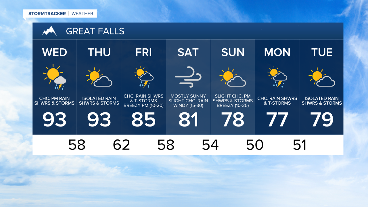
We are going to have decreasing clouds tonight with some isolated rain showers and thunderstorms around, mainly before midnight and mainly in eastern Montana. It is also going to feel nice outside tonight as lows are going to range from the mid 50s to the mid 60s. There is also going to be a little bit of a breeze around this evening as sustained wind speeds are going to be between 10 and 15 mph.
For tomorrow, we are going to have increasing PM clouds with a few scattered rain showers and thunderstorms around, mainly during the afternoon and evening, as a disturbance passes through our area. It is also going to be hot tomorrow as highs are going to be in the upper 80s and low to mid 90s in most locations. There is also going to be a little bit of a breeze around tomorrow in eastern Montana and along the Hi-Line as sustained wind speeds are going to be between 10 and 15 mph.
On Thursday, we are going to have increasing PM clouds with a chance of rain showers and thunderstorms, generally during the late afternoon and evening, as another disturbance begins to approach our area. It is also going to continue to be hot on Thursday as highs are going to be in the low to mid 90s in most locations.
There are then going to be some scattered rain showers and thunderstorms around on Friday as a cold front passes through our area. Cooler temperatures are also expected on Friday as highs are only going to be in the 80s in most locations. It is also going to be breezy Friday afternoon and evening, especially in central Montana, as sustained wind speeds are going to be between 10 and 20 mph.
For this weekend, we are going to have mostly sunny skies with a slight chance of rain showers and thunderstorms on Saturday, and increasing clouds with a slight chance of PM rain showers and thunderstorms on Sunday. It is also going to feel nice outside this weekend as highs are going to be in the upper 70s and low to mid 80s in most locations on Saturday, and the mid to upper 70s and low 80s in most locations on Sunday. Sadly, along with these nicer temperatures comes stronger winds as it is going to be windy on Saturday as sustained wind speeds are going to be between 15 and 30 mph, and it is going to be breezy on Sunday as sustained wind speeds are going to be between 10 and 25 mph.
We are then going to have partly to mostly cloudy skies with some isolated rain showers and thunderstorms around next Monday and Tuesday as a couple disturbances pass through our area. The high temperatures early next week are also going to continue to be a bit below average for this time of year as highs are going to be in the mid to upper 70s and low 80s in most locations.