Due to wildfires burning locally, and due to wildfires burning in other states throughout the western U.S., smoky and/or hazy skies are expected for the foreseeable future here in Montana. With this smoke in the air, the air quality is likely going to continue to be in the “moderate” or “unhealthy for sensitive groups” categories for the foreseeable future, so if you are sensitive to increased particulates in the atmosphere, then you may want to try and limit your time outdoors. There is also an Air Quality Alert in effect until at least 9am Sunday morning for a decent chunk of Montana due to this less-than-ideal air quality.

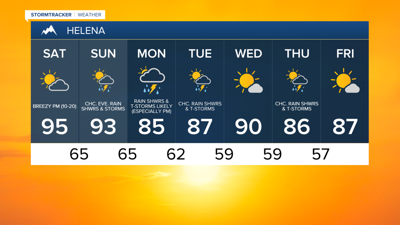
For tonight, we are going to have partly cloudy skies with a slight chance of rain showers and thunderstorms. It is also going to be mild tonight as lows are going to be in the upper 50s and low to mid 60s. We are then going to have partly cloudy to mostly sunny skies tomorrow with a slight chance of rain showers and thunderstorms. It is also going to be hot tomorrow as highs are going to be in the low to mid 90s. Breezy conditions are also expected tomorrow afternoon/evening along the Hi-Line and in central Montana as sustained wind speeds are going to be between 10 and 20 mph.
On Sunday, we are going to have partly to mostly cloudy skies. Many locations in our viewing area are also going to be dry on Sunday, but locations south and west of Great Falls are going to have a chance to see some rain showers and thunderstorms during the evening as some monsoonal moisture begins to return to our area. It is also going to be hot again on Sunday as highs are going to be in the low to mid 90s in most locations. There is also going to be a bit of a breeze around Sunday afternoon/evening along the Hi-Line and in central Montana as sustained wind speeds are going to be between 10 and 20 mph.
There are then going to be scattered rain showers and thunderstorms around on Monday, especially during the afternoon and evening and especially in locations south and west of Great Falls, as a disturbance begins to pass through our area. Some of the precipitation we see on Monday may also be heavy, and flash flooding may be a concern in some locations south and west of Great Falls. We are then going to have a chance to see some more rain showers and thunderstorms on Tuesday as this disturbance leaves our area. We are also going to have increasing clouds on Monday and decreasing clouds on Tuesday.
The temperatures on Monday and Tuesday are also going to be cooler than the temperatures this weekend are going to be as highs are going to be in the mid to upper 80s in most locations. It is also going to be breezy on Monday along the Hi-Line as sustained wind speeds are going to be between 10 and 20 mph. There is also going to be a little bit of a breeze around on Monday in eastern Montana and there is going to be a little bit of a breeze around on Tuesday in central Montana as sustained wind speeds are going to be between 10 and 15 mph.
Mostly to mainly sunny skies and mostly dry conditions are then expected on Wednesday as high pressure is going to be in control of our weather. We are then going to have partly cloudy skies with a chance of rain showers and thunderstorms on Thursday as another disturbance passes through our area. Mostly sunny skies and mostly dry conditions are then expected on Friday.
It is also going to be hot on Wednesday as highs are going to be in the upper 80s and low 90s in most locations. The temperatures are then going to be back near average next Thursday and Friday as highs are going to be in the mid to upper 80s in most locations. There is also going to be a little bit of a breeze around in spots on Wednesday and Thursday as sustained wind speeds are going to be between 5 and 20 mph.