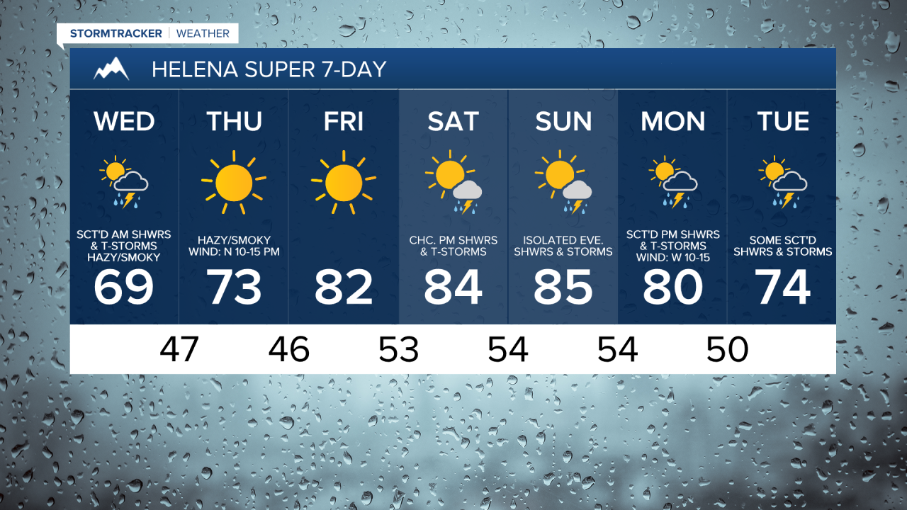
Wildfire smoke from Canada has been brought into Montana by a cold front. This smoke will continue to increase from north to south as we go through tonight. On Wednesday and Thursday, the general wind direction is going to be out of the north, which means that the haze and smoke will continue to be an issue. The air quality at times may be unhealthy not just for sensitive groups but for everyone, so please try and limit your time outdoors over the next few days and make sure to keep all windows closed to keep the smoke out. The wind direction will change to the southwest for Friday and the weekend, which will hopefully help bring some cleaner air into our area.
There are going to be scattered showers and thunderstorms around this evening and tonight as a disturbance passes through our area. For tomorrow, we are going to have decreasing clouds with scattered showers and storms around during the morning, generally around the Helena, Great Falls, Lewistown, and Glasgow areas. This precipitation will quickly move southward as we go through the day, with most of central and north-central Montana dry by lunch time.
It is also going to be mild tonight as lows are going to be in the 50s and mid to upper 40s. It is then going to be cooler tomorrow than it was today as highs are going to be in the 60s and low to mid 70s. There is also going to be a bit of a breeze around tonight as sustained wind speeds are going to be between 5 and 20 mph. It is then going to be breezy tomorrow in locations east of I-15 as sustained wind speeds are going to be between 10 and 25 mph, and wind gusts up to 40 mph are going to be possible at times.
Lots of sunshine and mostly dry conditions are then expected on Thursday and Friday as high pressure is going to be in control of our weather. On Thursday, highs are going to be in the mid to upper 60s and low to mid 70s. It is then going to be warmer on Friday as highs are going to be in the mid to upper 70s and low to mid 80s.
On Saturday and Sunday, we are going to have increasing clouds with some isolated showers and thunderstorms around during the PM hours. It is also going to be warm this weekend as highs are going to be in the mid to upper 70s and low to mid 80s.
There are then going to be some scattered showers and thunderstorms around on Monday and Tuesday as a couple disturbances pass through our area. We are also going to have partly cloudy skies on these two days. The temperatures are also going to cool down over these two days as highs are going to be in the 70s and low to mid 80s on Monday and the 70s and mid to upper 60s on Tuesday. There is also going to be a bit of a breeze around on Monday as sustained wind speeds are going to be between 10 and 20 mph.