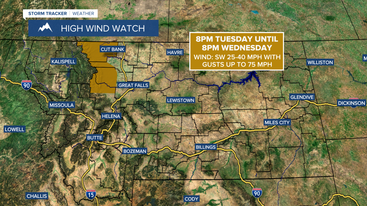
A High Wind Watch is in effect for the Rocky Mountain Front from 8pm Tuesday until 8pm Wednesday. Sustained wind speeds are going to be between 25 and 40 mph, and wind gusts up to 75 mph are going to be possible at times.
Snow is going to gradually taper off from north to south this evening, with only lingering mountain snow showers expected tonight in central Montana. Slippery road conditions are also expected tonight from the snow that we saw during the day today, so please be careful when driving and give yourself plenty of extra time to get to where you need to go. We are also going to have frigid temperatures again tonight in north-central Montana as lows are either going to be in the single digits below zero or the single digits above zero. In south-central Montana, it is not going to be nearly as cold as lows are going to be mid to upper teens and low to mid 20s.
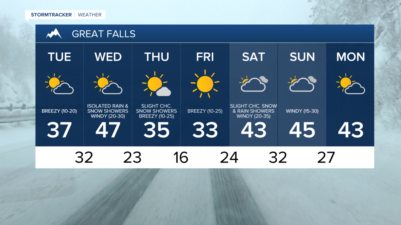
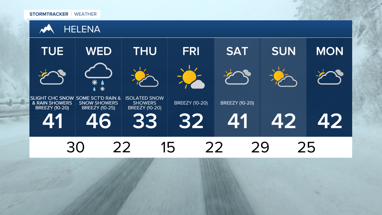
For tomorrow, we are going to have mostly to partly cloudy skies with a few lingering mountain snow showers around. It is also going to be warmer tomorrow than it has been over the past couple of days as highs are going to be in the 30s and low 40s in locations that are not along the Hi-Line. Along the Hi-Line, it is going to be another cold day tomorrow as highs are only going to be in the 20s. The wind is also going to start to pick up tomorrow, and it is going to be a bit breezy tomorrow afternoon and evening as sustained wind speeds are going to be between 10 and 20 mph.
On Wednesday, we are going to have decreasing clouds with some scattered rain and snow showers around in south-central Montana and some isolated rain and snow showers around in north-central Montana. Windy conditions are also expected on Wednesday as a cold front begins to approach and pass through our area as sustained wind speeds are going to be between 15 and 35 mph, and wind gusts up to 50+ mph are going to be possible at times. We are also going to have above average temperatures on Wednesday as highs are going to be in the upper 30s and low to mid 40s.
Much colder temperatures are then expected for the end of the work week as highs on Thursday and Friday are only going to be in the upper 20s and low to mid 30s. It is also going to be breezy on these two days, especially in north-central Montana, as sustained wind speeds are going to be between 10 and 25 mph. We are also going to have partly cloudy to mostly sunny skies on these two days with some isolated snow showers around.
For this weekend, we are going to have partly to mostly cloudy skies with a few isolated snow and rain showers around, generally west of I-15. The temperatures are also going to be warmer this weekend than they are going to be for a lot of this week as highs are going to be in the upper 30s and low to mid 40s. It is also going to be windy this weekend, especially on Saturday, as sustained wind speeds are going to be between 15 and 35 mph, and wind gusts up to 50+ mph are going to be possible at times.