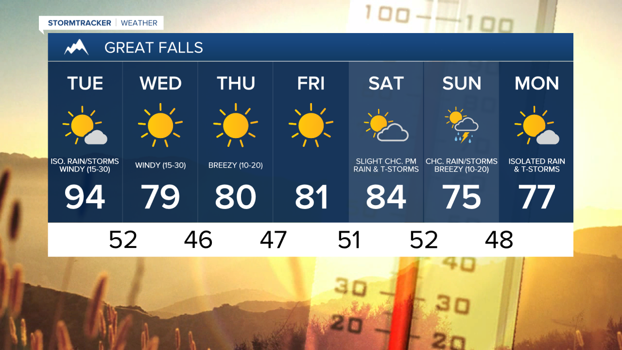
Record heat is expected today in eastern Montana as highs are going to be above 100°. In central Montana, it is going to be slightly cooler today than it was yesterday, although it is still going to be very hot as highs are going to be in the mid to upper 90s and lower 100s. There are also several heat alerts in effect for today due to this heat as there is a Heat Advisory in effect for east-central Montana until 8pm today, and there is an Excessive Heat Warning in effect for eastern Montana from 9am until midnight. Basically, try and limit your time outdoors today, and if you do have to be outside at all, make sure you stay hydrated and take frequent breaks in the shade or AC.

It is also going to be windy today, especially during the afternoon and evening, as sustained wind speeds will be between 15 and 25 mph and wind gusts will approach 40 mph at times. Now since it will be windy, hot, and pretty dry today (relative humidity as low as 10%), there is a Red Flag Warning in effect for most of central and eastern Montana from 9am today through midnight tonight, as any new fires that start or fires that are currently burning are going to be able to spread rapidly. There is also a Lake Wind Advisory in effect until 6pm today for Fort Peck Lake.

We will have mostly to mainly sunny skies today with a few isolated rain showers and thunderstorms around during the evening as a cold front begins to work its way through our area.
For tonight, there will be partly cloudy to mostly clear skies with a chance of rain showers and thunderstorms as this cold front works its way through. It will continue to be windy tonight as sustained wind speeds are going will be between 15 and 30 mph, and it will be cooler tonight, as lows are will dip into the low to mid 50s in central Montana and the low to mid 60s in eastern Montana.
Lots of sunshine and dry conditions are expected tomorrow, Thursday, and Friday as high pressure will be in control of our weather. The temperatures on these three days will be a lot more comfortable than the temperatures today, with highs in the upper 70s and low to mid 80s. It will be windy tomorrow as sustained wind speeds are going to be between 15 and 30 mph, and it will be breezy on Thursday as sustained wind speeds will be between 10 and 20 mph. Critical fire weather conditions are also possible again tomorrow as it will be warm, windy, and dry.
On Saturday, we will see increasing clouds with a slight chance of rain showers and thunderstorms during the afternoon and evening as a storm system approachs. We will have a chance to see some rain showers and thunderstorms on Sunday as this storm system passes through our area. The temperatures will cool down some from Saturday to Sunday as highs on Saturday will be in the mid to upper 80s, and highs on Sunday will be in the mid to upper 70s and low 80s. There will also be a bit of a breeze on both Saturday and Sunday with sustained winds between 10 and 20 mph.